(Girl Undercut)

Skagit River Journal

of History & Folklore
Subscribers Edition, where 450 of 700 stories originate
The most in-depth, comprehensive site about the Skagit

Covers from British Columbia to Puget Sound. Counties covered: Skagit, Whatcom, Island, San Juan, Snohomish & BC. An evolving history dedicated to committing random acts of historical kindness
Noel V. Bourasaw, editor (bullet) 810 Central Ave., Sedro-Woolley, Washington, 98284
Home of the Tarheel Stomp (bullet) Mortimer Cook slept here & named the town Bug

(Click to send email)
Site founded Sept. 1, 2000. We passed 5 million page views on June 6, 2011
The home pages remain free of any charge. We need donations or subscriptions to continue.
Please pass on this website link to your family, relatives, friends and clients.

Pioneering in the Cascade country
D.C. Linsley and Frank Wilkeson,
1870, Skagit river watershed

Part 2 (see biography of Linsley and Wilkeson)
Transcribed by Noel V. Bourasaw, Skagit River Journal of History & Folklore, ©2005
"Old Records Bring to Light Details of Railway Reconnaissance in the Northwest in 1870,"
from the Diary of the late D.C. Linsley, Locating Engineer, Northern Pacific Railway Co.,
From Civil Engineering magazine, June 1932, Vol. 2, No. 6, pp. 339-344.

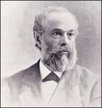
(D.C. Linsley)
D.C. Linsley

      In an unexplored, snow-covered wilderness at the crest of the Cascade Mountains, a hundred miles from the nearest white settlement, his only companions Indians unable to speak a word of English, an engineer was seeking a low pass for a railroad line in the spring of 1870. The diary of this intrepid engineer has just been uncovered in the offices of Chief Engineer Bernard Blum, M. Am. Soc. C. E., at the headquarters of the Northern Pacific Railway Company in St. Paul, Minn. It was written by D. C. Linsley, a New Englander [Vermont], and chronicles, with human interest detail, his heroism and dogged determination in performing his mission for the Northern Pacific, to locate a feasible mountain pass for a railroad line in the extreme northwestern corner of the United States. [Journal Ed. note: he was born Daniel Chipman Linsley, which was sometimes spelled Chapman in later life, but he usually went by his initials, as did many men of that period.] In the ten weeks between May 25 and August 3, 1870, he traveled 650 miles on foot, in canoe, and on horseback, mapping and charting a new country, then inhabited almost solely by Indians. Today's maps of that country show the location of "Linsley's Pass," named in his honor, at the head of the Wenatchee River in the State of Washington. Records of the Northern Pacific Railway have revealed nothing more concerning the career of this dauntless reconnaissance engineer.
      Specifically, the duty assigned to D. C. Linsley on April 28, 1870, by Edwin F. Johnson, then chief engineer of the Northern Pacific Railway, was to make a reconnaissance of the country near latitude 48 degrees north, between the west boundary of Idaho Territory and the Pacific Ocean, to determine the practicability of carrying the main line of the Northern Pacific in that direction from the Clarke River Valley to Puget Sound.
      At that time the Northern Pacific was in the earliest stages of constructing the first northern transcontinental railroad, and was planning in the next few years to build a line through the Cascade Mountains. Mr. Linsley was one of a number of engineers sent out to find a practicable pass for the railroad. In pursuance of his instructions, Linsley and his party started from Seattle eastward and made a complete circle, going first up the Skagit River and returning to Seattle via the Columbia, Yakima, and Cedar rivers. He approached the summit of the Cascades twice in the course of the exploration and reported on two possible passes over the mountains.
      The start of the Linsley adventure was from Whatcom, now Bellingham, Wash. The story, as graphically told in the little leather bound volume recently unearthed, continues as follows:


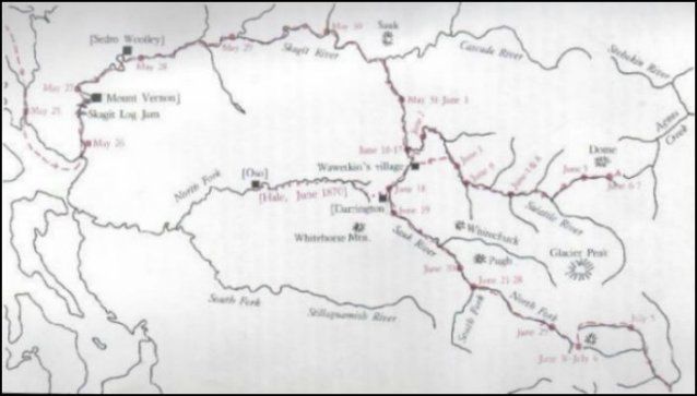
(Linsley survey map)
      This map of the Linsley survey is excerpted from the April 1981 issue of Northwest Discovery, the Journal of Northwest History and Natural History magazine. That issue contains Linsley's full field diary and letters and extraneous notes from before and after the expedition itself. It was edited by Harry M. Majors and Richard C. McCollum. The article was also published in book form by Northwest Press of Seattle.

Survey begins from Whatcom, May 25, 1870
    Any time, any amount, please help build our travel and research fund for what promises to be a very busy 2011, traveling to mine resources from California to Washington and maybe beyond. Depth of research determined by the level of aid from readers. Because of our recent illness, our research fund is completely bare. See many examples of how you can aid our project and help us continue for another ten years. And subscriptions to our optional Subscribers Online Magazine (launched 2000) by donation too. Thank you.


(Plumeria)
We recently visited our newest sponsor, Plumeria Bay, which is based in Birdsview, just a short walk away from the Royal family's famous Stumpranch, and is your source for the finest down bedding. See our Journal feature on this local business and learn more details and how to order items at their website.

      "May 25, 1870: Left Whatcom at 8 a.m. in two canoes for the Cascade Mountains via Skagit River. Party consists of H. C. Hale, Frank Wilkeson, and John A. Tennant [a resident of Whatcom], myself, and six Indians. . . . Coasted along the east shore of Bellingham Bay southerly to Swinomish River. Reached the house of the Indian agent, Dr. Deree, and was most hospitably received by him. Found we are natives of the same town. Distance traveled, 25 miles." [Ed. note: Linsley recorded Frank's name incorrectly as Wilkenson in his journal. The magazine spelled it as Wilkinson. We have edited and spelled it correctly from here onwards.]
      The second night of the journey was spent at W. H. Sartwell's, a short distance up the Skagit. This was in low country and Linsley notes the width of the river and its comparative shallowness. The shores were wooded, mostly with cottonwood and alder trees. The cottonwoods grew to a huge size; one, measured 6 ft. above the ground, was 27.9 ft. in circumference. From Sartwell's the party went on up the Skagit.
      "Friday, May 27: At noon we had passed the portage and a heavy rain having set in, we camped on the west bank of the stream. Here we met Sosumpkin, chief of the Skagit tribe of Indians. After a long talk participated in by nearly every grown member of the tribe present, we succeeded in procuring canoes and Indians to continue the ascent of the river. The canoes we have had to this point are constructed for use on the sound and are quite different in shape from the river canoes. . . . Fir, spruce, and cedar are beginning to appear and are of giant size. I measured two cedars, 6 ft. above the ground. One measured 20 ft. and the other, 24 ft. 8 in. in circumference. . . . We have passed the last settlers' cabin and are fairly in the Indian country." [Ed. note: we hope that a reader will know of the Indian Sosumpkin.]
      That night it began to rain and the river rose to freshet stage, making progress against the current hard work. They saw "immense cedar, fir, and spruce trees floating down the stream with their enormous roots and branches grating and crushing against the rocks at the bottom with a noise that could be heard a long distance." Notwithstanding almost constant rain the river fell slightly. The diary continues:


Upper Skagit river, May 30
      "Monday, May 30: We noticed, today, evidence of the extraordinary durability of the cedar of these forests. The stump of a cedar 7 ft. 6 in. in diameter had been hollowed out by fire until the shell was only some 6 to 10 in. thick, with a jagged and splintered top, some portions of which were 20 to 25 ft. high. Inside this stump is now growing a spruce tree 10 ft. 2 in. in circumference. . . . After making about ten miles we camped at the mouth of Baker's River. . . . It comes in from the north and has its source among the glaciers of Mount Baker. The Indian name is Novoulturn, signifying 'white water.' "
      By May 31 the party had reached the mouth of the Sauk River, which, as shown in Fig. 1, enters the Skagit from the south, and began its ascent.
      "Tuesday, May 31: Being anxious to save our rations which, owing to the slow progress we are able to make, are in danger of running out, I camped early to give our hunter a chance to try his hand. He returned just at dusk with one old bear and two cubs as a result of his hunt.
      "From all the information I can get from the Indians, there is no prospect of finding any pass through the mountains to Lake Chelan, but in order to ascertain definitely whether this is so I have concluded to make a hurried trip in that direction, leaving the bulk of the party here to await the arrival of Mr. Hale [who had been left at Sartwell's to keep an hourly record of temperature and barometric pressure]. . . .


Across Cascade Pass to Lake Chelan
      "Wednesday, June 1: Remained in camp all day preparing to divide party and rations to make an exploration in the direction of Lake Chelan. The Indians make great objections to going, and I may be compelled to await at this place Mr. Hale's arrival. A grand pow-wow is going on to-night among them in relation to this matter, and speech-making enough for half a dozen political meetings is being done. The only objection they make is that the route is so hard
      "Thursday, June 2: Another long pow-wow this morning which finally resulted in a new trade by which I am to give the Indians an advance of 30 cents per day for canoe work after this date, the wages when in camp or traveling on foot to remain the same as heretofore. . . . It was nearly nine o'clock before we got off. I took with me Mr. [John] Tennant and four Indians, leaving Mr. Wilkeson in camp with the remainder of the party. . . . We lunched upon salmon, which the Indians had taken with a spear . . . and at three o'clock commenced the ascent of the Suittle [Suiattle]."
      The party of Mr. Linsley reached the head of navigation on the Suiattle River for canoes by Sunday.
      "Sunday, June 5: We left our camp, our canoe, and every pound of baggage that could possibly be spared, at 6:30 [a.m.] and proceeded up the valley of the stream. The trail is very straight and no one but an Indian could possibly follow it."
      At noon they left the Suiattle and turned into a creek entering it from the east, the Kaiwhat, probably the present Sulphur Creek.
      "From the north bank of this creek the snow peaks rise almost perpendicularly. Any number of little rivulets creep out from under the enormous snow banks and tumble down the rocky sides of the mountains. I noticed one which I estimated fell 1,000 ft. in a nearly perpendicular descent. The timber on the Kaiwhat is the best I have seen. The cedar particularly is most remarkable. I think on some acres 20 trees might be cut that would square 15 in. for 50 ft. and be perfectly straight. The fir timber is also very fine, thick, and thrifty, but not so large as I .have seen lower down. . . .
      "Monday, June 6 — I spent two hours this morning in a partially successful attempt to repair one of the barometers. . . . Our route continued up the Kaiwhat, mostly through open woods of magnificent fir and cedar timber with occasionally an alder thicket or a windfall for variety. . . .
      "At three o'clock I saw two cinnamon or brown bears quietly feeding in plain view not more than 300 ft. distant. One was a very large animal and the other apparently but one or two years old. Mr. Tennant had the only rifle in the party. He fired at and wounded the large one but it escaped. . . . We camped on the edge of a snow bank at the foot of a very steep ridge . . . which the Indians tell us is the pass."


Pass to Lake Chelan from Kaiwhat creek reached
      During the following day the return trip to the point where the canoe had been abandoned was made in a forced march of 25 miles through dense forests without any kind of path except one that an Indian could find. The next day was:
      "Thursday, June 9: There was a long conference among the Indians last night in relation to the possibility of going down the river in a canoe while the water is at its present stage. It seems to me utter madness to attempt it, but I had determined to abide by their decision if backed by the opinion of Mr. Tennant. It was finally agreed that the Indians should take all the luggage in the canoe and try the navigation, while Mr. Tennant and myself proceeded on foot along the shore.
      'We proceeded thus about two miles when the Indians advised us to get in the canoe, saying the worst water to be met for several miles had been passed. We did so after following the suggestive advice of the boatman to put off our pistols, coats, etc., and to sit upright in the bottom of the canoe. Mr. Tennant was given an Indian bucket, and the bread pan was placed in my hands, with an intimation that in case the canoe shipped much water it would be well enough for us to throw it out. The Indians, stripped of all clothing save a shirt and belt, stood up, two in each end of the canoe, each having at his feet a paddle and in his hands a stout pole some 12 to 15 ft. long.
      "They push out from the little eddy in which our frail craft is rocking gently. The current seizes the bow of the canoe and in an instant we are whirling down the stream at a fearful rate. It is comparatively smooth water here, but just ahead a line of white and tossing foam stretches entirely across the stream from bank to bank, broken only by the dark tops of boulders that occasionally for an instant appear above the surface of the current. To enter that line of barring breakers seems the wildest madness, but it is now too late to avoid them. The eye gathers in an instant all the surrounding objects. The glancing shores show the fearful rate at which we are going. We notice the enormous size of the rocks ahead and wonder at what point we are going to be plunged beneath the torrent. . . .


Indian guides
      "Attention is drawn to the Indians. Their usual listless manner is gone. Each has assumed an attitude that would form a fit subject for a sculptor. Their black eyes, fairly glistening with excitement, are riveted on the wild whirls into which we are rushing. But we are close upon the foremost breaker. A volley of gutterals breaks forth from the chief in the stern and is answered by similar sounds from each of the crew. The poles are dropped to the bottom and by an instantaneous and powerful jerk the canoe's course is changed a trifle, so that it clears by a hand's breadth the first rock we meet. A frightful barrier is just ahead. The poles are again thrust to the bottom. One is broken in a twinkling, but before our eyes have assured us of the fact, the holder has grasped a paddle and is working it with desperate energy.
      "The bow of the canoe meets the barrier. . . . The Indians totter. . . . A spray flies over us, and a barrel of water pours into the canoe. We work our bailing dishes with all the strength we can muster. We catch glimpses of the rocks as we fly by. The canoe tosses and whirls in every direction, apparently ungovernable but really controlled with amazing dexterity. The water now dashes over the side of the canoe incessantly and we literally bail for life. A moment more and the triumphant shout of the Indians rises above the roar of the water and announces that we are for a moment safe. After several miles of this kind of navigation, the Indians pulled up and announced their conviction that it would be unsafe to proceed further until the water falls."
      In this opinion Linsley heartily concurred, and drenched to the skin the party landed and proceeded to get dry. As there was no improvement in the river the next day, Mr. Linsley and Mr. Tennant left the Indians to take the canoe on down the river, and crossed the mountain separating the Suiattle and Sauk rivers to the camp established by Mr. Wilkeson. Here they found an Indian village, and were met by chief Whometkan's son, who promised any assistance his tribe could give. Most of the tribe were absent on a fishing expedition but on their return the personal services of the chief himself were secured for the trip over the Cascades. [also most commonly spelled Wawetkin or Wawitkin, an anglicized attempt at his Indian name — see this Journal website. This story will soon be changed to this address. If neither file connects, please email us.


Indians guide the party to the Sauk river
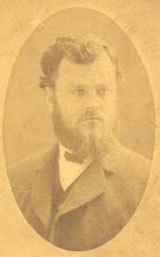
(Frank middle-age)
Frank Wilkeson in middle age, circa 1883, about the time he first began touring mining camps in the Rockies and the Northwest states for newspaper columns. Photo courtesy of Wilkeson descendant Elizabeth Edwards

      "Thursday, June 16 — Sosumpkin returned at dusk with a note from Mr. Tennant dated this morning, at the head of navigation on the Sawk [River, now the Sauk]. It seems Sosumpkin has proved faithless, and after going to the head of navigation [on the Sauk] under the clearly understood arrangement that he was to go over the mountains for horses, he, at the last moment, refused flatly to go. It won't do to discharge him as yet as he has too much influence below here on the river. But I hope in a few days to let him go. The water in the streams has again become clear enough to get salmon, and the Indians killed four today. They take with them a spear about 17 ft. long, forked at the end with a barbed point of iron or horn stuck loosely on each prong of the fork. . . . The barbed points pull off the ends of the spear, but the fish is held and pulled on board by the thongs which attach the barbed points to the spear. If the barbs were fixed rigidly on the end of the spear, the floundering of the fish would break the slender spear. . . . "
      Mr. Linsley remained in camp until the return, on Saturday, of Mr. Wilkeson, who had been long delayed in getting drafts cashed. On Saturday afternoon the party started up the Sauk River in three canoes. With Mr. Wilkeson and Mr. Linsley were 11 Indians. They stopped at Chief Whometkan's village to get a supply of smoked salmon, and there they also bought eight quarts of good strawberries, according to a note in the diary. The next two days the little party struggled on up the river. On Tuesday they were met by Mr. Tennant, who was returning for more provisions. Mr. Hale had been left at the main forks of the Sauk higher up, where the main party later found him comfortably established in a bark hut that he had constructed while he waited. Mr. Tennant had sent Indians on to the Columbia River to get horses and had put others to work opening a trail to the top of the mountain. From this base Mr. Linsley again set his forces in motion. The next entry in the diary reads:
      "Wednesday, June 22: This morning I dispatched Mr. Wilkeson with one canoe and four Indians to examine the trail leading from the Skagit River to Whatcom on Bellingham Bay; thence to proceed to Seattle and prepare map of our explorations to this point, and then, unless otherwise ordered, meet me on the Columbia River by the way of the Snoqualmie Pass. Mr. Hale I dispatched with a canoe and three Indians to cross over to the Steilagwamish [Stillaguamish] River by the trail before mentioned and thence descend that stream to Puget Sound. I sent letters and dispatches to Governor Smith and home by him, and directed him to hasten up the $600 which I telegraphed General Sprague for last Sunday to have within three or four days, and which has not yet come to hand. I cannot leave the summit until that is received as from that point I expect to travel as fast as a messenger would."


Crossing the divide into the Wenatchee valley

Patricia McAndrew's book about Frank Wilkeson, The Old Soldier Goes Fishing, will be published in the 2012-13 period. For more details about ordering the book, please see this site

      The next few days Mr. Linsley spent alone in the little camp. The wait was monotonous, broken only by the arrival of four Indians, who returned to pick up more rations to carry to the summit. Mr. Linsley felt he must not go until he received the money that he had sent for, but the arrival of the second party of Indians from Mr. Tennant on Tuesday, June 28, decided him to leave the camp and go on up with one Indian to join Mr. Tennant on the summit.
      "Thursday, June 30: We reached the head of the valley, which has an elevation of about 3,700 ft. above tide. . . . Turning abruptly to the left, we ascend a very steep ridge some 1,300 ft. high and stand upon the summit of the pass, 5,042 ft. above the sea. The pass is about 40 or 50 rods wide and half a mile long. . . . It is bounded on both sides by peaks 1,500 to 3,000 ft. higher than the pass itself. . . . Seeing a mountain goat or sheep high up on a neighboring peak, I dispatched two Indians to endeavor to get it to add to our stock of rations, which are rapidly diminishing. . . . About dusk the hunters returned, having captured their game. It was a buck and the Indians say a large one.
      "Friday, July 1 — Discharged and sent home all our Indians but three, two of whom are at the camp at the mouth of the forks waiting for a messenger. Indians arrived with horses at a point down the east slope of the mountains about five miles below here, which is as near as they can come on account of the snow. Dined off a goat steak, which, although tough, was well flavored. A fat grouse, known as the blue grouse, furnished me an excellent supper. . . . A humming bird paid a visit this afternoon and spent some time about the trees under which we are camped. It is certainly odd for a Yankee to find these forms of animal life where the snow is lying 7 ft. deep on the ground
      "Saturday, July 2 — Mr. Tennant and I left camp early this morning and ascended the high peak that bounds the pass to the north. . . . The elevation was 7,900 ft. above the sea. The view was very fine in every direction. . . . It is very evident that there is no other pass from the Sawk to the Wenatchee than the one leading from the head of the fork. . . . We discovered that a pass exists on the north as well as on the south side of this mountain, which, although not as low as the one we have followed, is a much less distance across. . . . On our way we shot two blue grouse. At 5 p.m. an Indian reached me from the forks of the Sawk with the most unwelcome news that no messenger had reached there up to this morning and that the Indian Albert left there was sick with dysentary. Mr. Tennant started immediately down to him with all our old party. I have left with me only Jim and the two Indians who brought the horses. . . . I have not rations for more than a week, and I dare not risk keeping the Indians with the horses [from the Columbia] any longer than Wednesday, as they are now anxious to return. My position is a little uncomfortable . . . on top of the Cascade Mountains with three strange Indians for my only companions, none of whom can talk a word of English. . . . "


The party receives its stipend
      A tunnel on the north pass was estimated at one and one-half miles long. On Monday, the Fourth of July, both Mr. Tennant and Mr. Hale arrived at the camp on the summit with the long expected $600. Mr. Hale, after wrecking a canoe on his way down the Stillaguamish River, had gone back to Sartwell's on the Skagit River, obtained the expected money, and returned immediately. He was re-dispatched to Seattle to obtain another $1,000 from General Sprague and directed to meet the party on the Columbia River. The diary continues with the narrative of events on the next day.
      "Tuesday, July 5: Mr. Tennant and I started for the Columbia River by way of the north pass [marked Linsley's Pass on the map], which I am satisfied is the only practical route. . . .
      "Wednesday, July 6: We left camp at 5:30 and proceeded down the stream. As we worked our way slowly along the side of the mountain (the thickets bordering immediately upon the streams were almost impossible) we passed close to the feet of a number of the most beautiful cascades, several of them having a fall of more than 1,000 ft. . . . For a mountain line think this unusually favorable from the summit to this point. As soon as our horses could be packed we started down the stream and found a very good trail. . . . "
      With eight horses, obtained from the Columbia Indians, o carry their baggage, the party proceeded down the Wenatchee River on foot. Mosquitoes were troublesome and the river and its tributaries were high, but by Sunday, the tenth, the intrepid group of men had reached the lower canyon of the river, where it is walled in by mountains of rock from 1,000 to 5,000 ft. high.
      "Sunday, July 10 — After breakfast . . . Mr. Tennant and I walked up the canyon about a mile . . . . The general fall of the river I estimate at 40 to 50 ft. per mile, but for about a mile at the lower end it falls faster, say 70 to 80 ft. per mile. The stream flows over and around huge boulders of granite and seems one mass of snowy foam. Here the salmon collect in great quantities and hither every year come great swarms of Indians to lay in their year's stock of food. Some two or three hundred are now camped along here, all as busy as a swarm of bees.
      "The fish are taken by means of a barbed hook attached to the end of a slender pole from 15 to 30 ft. long . . . . The women then take them, cut them up, and hang them on poles to be dried and smoked. As we walked along . . . [we passed] little groups of women and children clustered among the huge boulders . . . , sheltered from the burning sun by a few boughs of trees spread on poles supported on forked sticks . . . . "
      Mr. Linsley says of this canyon route: "On the whole, I think the valley of the Wenatchee a remarkably favorable one for the construction of a road in this section of the country." From the canyon to the mouth of the Wenatchee the river was found to be crooked, but railroad work would be light.


Columbia river reached
      "Monday, July 11 [On the Columbia, at the trading post of J. G. Ingrim [Ingram?], who knew all that country thoroughly] . . . . The celebrated chief of the Wenatchee, Moses, who was the most prominent leader in the last Indian war, came into camp. He is by far the finest looking Indian I have seen and is evidently a man of ability. He is wealthy, having large herds of horses and cattle, and has a wide influence over other tribes than his own, with whom his word is law.
      "Tuesday, July 12: At 2 p.m. started up the river [Columbia] in a canoe borrowed of Mr. Ingrim. . . . I have determined to try it with our two men, Whometkan and his brother Jim. The Indians about here have nearly frightened them from going with accounts of the 'dead water,' but I have no fear of that.
      "Thursday, July 14: At eight o'clock this morning we reached the outlet of Lake Chelan. . . . The water of the lake reaches the Columbia through a very crooked and narrow gorge, walled in by precipitous cliffs of basaltic rock from 400 to 800 ft. high. Lake Chelan is considerably above the Columbia River and its water reaches the latter stream without any perpendicular fall, but by a succession of rapids. . . . At 2:30 we started up the lake and at night camped at a point ten miles above the outlet. . . . "
      For the next three days the wind was so terrific that only a short distance could be traveled each day. The canoe that the party had was a most unseaworthy affair, and although they made several starts, were obliged to give up and await the lulling of the wind. The journey was resumed the following Tuesday in a large canoe obtained from other Indians.
      "Tuesday, July 19 — The wind moderated about two this morning and at quarter before three we again started up the lake. After going about two miles, the wind increased and we were compelled to go on shore. At quarter before seven we again started and reached the head of the lake at about 1 p.m. . . . Entering the mouth of the Chelan [now Stehekin] River, we proceeded . . . up the stream, which is here about 150 ft. wide and 1 to 2 ft. deep, with a strong current flowing over a bed of coarse gravel. Having lunched and procured poles for working our canoe . . . we continued on our way about 7 miles and camped on a sand bar.
      "The route by Lake Chelan has, on the whole, proved much better than I expected. The length of the lake is about 40 miles. Of this about 6 miles will be very heavy rock work. About one mile of tunneling of various lengths from 100 to 800 ft. About 16 miles will be very easy of construction and about 10 miles will be somewhat above the average. Curves of 800 to 1,000 ft. must be used to avoid very expensive work, but the grades will be very light and the greater portion of the way level. I think the distance can be shortened about four miles, but this will be the lightest part of the work. The rock work will be mostly in granite and basaltic rock. This will be hard to cut but a great portion of it will be side work.
      The next few days were spent by Mr. Linsley and his party in following the small streams that empty into the Chelan. These streams head near the upper tributaries of the Skagit and Suiattle and therefore it was possible to connect the exploration made up the Kaiwhat branch of the Suiattle with that of the Chelan. This appeared to be the only practicable connection. Mr. Linsley stated his conclusions as follows:
      "Sunday, July 24 — The result of the survey, or rather exploration, of the Chelan route is briefly this: The route is practicable with a heavy grade, say 80 to 90 ft., but the work will be heavy and expensive. The land, with the exception of that along the road for about 15 miles from the Columbia River, lying east of the summit, is worthless. The route will be shorter from the sound to the Columbia than any other.
      "About six [this morning] we started on our way back to the Wenatchee, where we had left the greater part of our supplies. We have had nothing on the trip but bacon and flour, and as our yeast powders have failed, it is pretty hard living. The entire stock of cooking utensils and furniture consists of a frying pan, a knife and fork, and a pint tin cup . . . . "
      Leaving the canoes to follow as fast as possible, Mr. Linsley and Mr. Tennant on Monday, July 25, made 60 miles to the mouth of the Wenatchee. There Mr. Hale, who had returned from Seattle, met the party with further instructions. Mr. Tennant and Mr. Wilkeson were left to explore the Spokane River while Mr. Linsley and Mr. Hale with an Indian guide made a rapid return to Seattle over the mountains by way of the Snoqualmie Pass and the Cedar River with their findings. They reached Seattle on Tuesday, August 2, and Mr. Linsley notes:


The party returns to Seattle
      "We reached Seattle at 11:30 a.m., having ridden in the last five days about 200 miles, much of the way over roads next to impassable. I find that since leaving Whatcom [May 25] I have lost 26 pounds in weight."
      After further reconnaissances on Puget Sound, Mr. Linsley left Seattle on August 6 to carry his findings to the officers of the Northern Pacific in New York, where he was to report on August 20. In his report Mr. Linsley summarized the possibilities of his explorations in the following words:
      "A good route can be had from the foot of Rock Island, three miles below the mouth of the Wenatchee, to the Spokane River with fewer obstacles than between the 'Sound' and the Columbia. Estimate of Route No. 1 from the mouth of the Skagit via Lake Chelan and the Columbia to the Spokane River about 50 miles below Lake Pend d'Oreille and 20 miles above the mouth of the stream. Distance, 326 miles. Cost, $16,000,000, or $50,000 per mile
      "Route No. 2, from mouth of Skagit via the Skagit, Sawk, and Wenatchee rivers and across the 'Great Plains' of the Columbia to same point on the Spokane as Route No. 1. Distance 347 miles. Cost, $13,000,000, or $39,000 per mile
      "A line up the Steilagwamish to Sawk summit would reduce the distance 10 miles, and save $250,000 in cost. The estimate would then read: distance, 337 miles; cost, $12,750,000, or $38,000 per mile."
      The expedition conducted by Mr. Linsley had very little bearing on the present location of the Northern Pacific line through the Cascade Mountains. It was one of several surveys and reconnaissances to determine the best route. It was neither the first nor the last of these surveys.
      The records of the railroad company do not disclose the details of Mr. Hale's long trip from the crest of the Cascades to Seattle and his return to the Columbia at the mouth of the Wenatchee via the Snoqualmie Pass, nor do they describe the difficulties of Mr. Wilkeson's party in exploring a route from the Skagit to Bellingham, or tell by what means Mr. Linsley was able sixty years ago to reach New York from Seattle in 14 days. [Journal editor note: the writer asked a good question. The only method we can think of is that Linsley would have sailed to San Francisco and boarded the Central Pacific Railroad to head east to Council Bluffs, Iowa, where he would then switch to both steamer and rail travel to New York City. That journey from coast to coast took 21 days when Linsley traveled west in May 1870. We will try to determine how long the return trip actually took.]


Links, background reading and sources

Story posted on Feb. 28, 2006, moved to this domain Oct. 27, 2011
Please report any broken links so we can update them
This article originally appeared in Issue 32 of our Subscribers-paid Journal online magazine


Getting lost trying to navigate
or find stories on our site?
Read how to sort through our 700-plus stories.

See this Journal Timeline website of local, state, national, international events for years of the pioneer period.
Return to the new-domain home page
Links for portals to subjects and towns
Newest photo features
Search entire site
Our monthly column, Puget Sound Mail (but don't call it a blog)
debuted on Aug. 9, 2009. Check it out.
(bullet) Remember; we welcome correction & criticism.
(bullet) Please report any broken links or files that do not open and we will send you the correct link. With more than 700 features, we depend on your report. Thank you. And do not give up if you find a link that seems to be closed. Just put the subject in the search box below. The story may have been moved to our new domain. Or just ask us and we will guide you to it.
(bullet) Did you enjoy this story? Remember, as with all our features, this story is a draft and will evolve as we discover more information and photos. This process continues until we eventually compile a book about Northwest history. Can you help with copies or scans of documents or photos? We never ask for your originals.
(bullet) Read about how you can order CDs that include our photo features from the first ten years of our Subscribers-paid online magazine. Perfect for gifts. Although it was delayed by our illness, it is due for completion in 2012.

You can click the donation button to contribute to the rising costs of this site. See many examples of how you can aid our project and help us continue for another ten years. You can also subscribe to our optional Subscribers-Paid Journal magazine online, which celebrated its tenth anniversary in September 2010, with exclusive stories, in-depth research and photos that are shared with our subscribers first. You can go here to read the preview edition to see examples of our in-depth research or read how and why to subscribe.

You can read the history websites about our prime sponsors
Would you like information about how to join them in advertising?

(bullet) Our newest sponsor, Plumeria Bay, is based in Birdsview, just a short walk away from the Royal family's famous Stumpranch, and is your source for the finest down comforters, pillows, featherbeds andduvet covers and bed linens. Order directly from their website and learn more about this intriguing local business.
(bullet) Oliver-Hammer Clothes Shop at 817 Metcalf Street in downtown Sedro-Woolley, 90 years continually in business.
(bullet) Peace and quiet at the Alpine RV Park, just north of Marblemount on Hwy 20, day, week or month, perfect for hunting or fishing. Park your RV or pitch a tent — for as little as $5 per night — by the Skagit River, just a short drive from Winthrop or Sedro-Woolley. Alpine is doubling in capacity for RVs and camping in 2011.
(bullet) Check out Sedro-Woolley First section for links to all stories and reasons to shop here first
or make this your destination on your visit or vacation.
(bullet) Are you looking to buy or sell a historic property, business or residence?
We may be able to assist. Email us for details.

Looking for something special on our site? Enter name, town or subject, then press "Find" Search this site powered by FreeFind
    Did you find what you were seeking? We have helped many people find individual names or places, so email if you have any difficulty.
    Tip: Put quotation marks around a specific name or item of two words or more, and then experiment with different combinations of the words without quote marks. We are currently researching some of the names most recently searched for — check the list here. Maybe you have searched for one of them?
Please sign our guestbook so our readers will know where you found out about us, or share something you know about the Skagit River or your memories or those of your family. Share your reactions or suggestions or comment on our Journal. Thank you for taking time out of your busy day to visit our site.

View My Guestbook
Sign My Guestbook
Email us at: skagitriverjournal@gmail.com
(Click to send email)
Mail copies/documents to Street address: Skagit River Journal, 810 Central Ave., Sedro-Woolley, WA, 98284.