Site founded Sept. 1, 2000. We passed 2.75 million page views in October 2008
The home pages remain free of any charge. We need donations or subscriptions to continue.
Please pass on this website link to your family, relatives, friends and clients.

(S and N Railroad)

Skagit River Journal

of History & Folklore
Subscribers Edition
The most in-depth, comprehensive site about the Skagit

Covers from British Columbia to Puget Sound. Counties covered: Skagit, Whatcom, Island, San Juan, Snohomish & BC. An evolving history dedicated to committing random acts of historical kindness
Noel V. Bourasaw, editor (bullet) 810 Central Ave., Sedro-Woolley, Washington, 98284
Home of the Tarheel Stomp (bullet) Mortimer Cook slept here & named the town Bug

(Click to send email)

Surveys for a Cascade wagon road began in 1895;
Alexander Ross first explored route in 1814

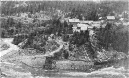
(Ruby Creek)
      This photo was taken at the confluence of Skagit River and Ruby Creek in 1906. The Ruby Inn roadhouse complex is in the upper right. Photo from the Callahan Collection, Seattle, Washington, courtesy of the National Parks Service.

By Noel V. Bourasaw, Skagit River Journal of History & Folklore, ©2005
      The Washington Legislature appropriated $5,000 in 1895 for a Cascade Pass wagon road to connect the areas of Washington state on both sides of the North Cascades mountain range, just south of the Canadian border. Mining interests clamored for what they called "mine-to-market" roads in all the counties that surrounded mines in the North Cascades mountain range. (Ed. note: Underlined links indicate either links to external websites or an endnote at the end of the article. Those annotations are followed by a newspaper article and a book excerpt about the Goat Trail and Devil's Elbow, two landmarks on the Cascade Pass Route.)
      Miners and mining companies had been frustrated since the 1878-80 gold rush at Ruby Creek on the upper Skagit River and the earlier discovery of coal and iron in the mountains across the Skagit from the little village of Hamilton. They saw a rich future for the ore discovered in those areas, but the transportation costs from those remote areas were exorbitant and miners wanted help from the Washington Legislature.
      A few years ago at a garage sale, I found an innocent-looking little brown leather field notebook, the kind that engineers tuck in their breast-pocket, which was entitled Rainy Pass, Route, 1895. On the inside front cover the author had inscribed "aug. 1895, BW Huntoon, Eng'r State Road" [see this Journal website]. Not a bad buy for 50 cents but for a long time it was a mystery. At about that same time I spent five years editing the North Cascades International Loop magazine and drove back and forth over the mountains dozens of times, all the while imagining what that trip must have been like on horseback. Over the years since that discovery I have collected newspaper articles and combed websites and in 2006 I will share the results.
      The State Legislature appointed the Washington Board of State Road Commissioners [hereafter cited as WBSRC] on March 22, 1895 to survey four different routes through the North Cascades. Surveyors took those routes through the mountains via 1. Slate Creek, 2. the North Fork of Thunder Creek (Park Creek Pass); 3. Cascade Pass; and 4. Rainy Pass. All four routes brought the surveyors well into today's national park [source: Gretchen A. Luxenberg].


European exploration began in 1814
      The first European exploration of the area dates back to Scotsman Alexander Ross, a fur trapper who arrived at Fort Okanogan in 1811 and was soon hired by American John Jacob Astor's Pacific Fur Company to man the new fort, which was actually just a glorified trading post in its original incarnation. In his first season alone, Ross traded for 1,500 pelts. As Sally Portman wrote in her 1993 book, The Smiling Country, Ross soon switched allegiance in 1814 to the new owners, the British North West Fur Company. The British company financed earlier exploration of the Columbia and Okanogan rivers by David Thompson, who met and made friends in 1811 with an Indian band he called the Smeethhowe. As Ross explained in his 1855 book, The Fur Traders of the Far West, the British assigned him in 1814 to explore a route over the Cascades to the Puget Sound, where merchandise could be traded to new Indian sources of furs. Luxenberg, noted that "Ross's larger purpose was to determine whether a feasible route existed between the inland trading posts and those located on Puget Sound." He succeeded somewhat in reaching the first goal but failed in the latter.
      That Indians had already carved out trails, mainly along the Methow, Twisp and Stehekin rivers, then across the Cascade crest and down the Cascade River to the Skagit and then to the Sound. Portman concluded that there is no written record of Indians ever crossing the mountains via the upper Methow River, Washington and Rainy passes, Granite Creek, Hart's Pass and Slate Creek, roughly the route of today's Hwy 20. In his 1972 book, Lake Chelan in the 1890s, the late Robert Byrd, a descendant of Chelan pioneers, addressed the Indian history:

      Traditionally the Skagit Indian word "Sta-he-kin" (Stehekin) means "the way through," "the crossing through place," or perhaps more literally, "the way we crossed through (the mountains)," and is, for many reaŽsons, believed to have been originally applied to a wide general area that included the present Stehekin Valley in part. The Indians apparently used several different ways of crossing the Cascade Range, and "Sta-he-kin" was the way they happened to be crossing at the time.
      It is . . . significant that the 1870 railroad reconnaissance party of D. C. Linsley recommended the old Indian crossing of the Cascades — Suiattle River, Sulphur, Spruce, Agnes, Stehekin and down Lake Chelan — as much the shortest from the Sound to the east. This writer strongly tends to believe — from the peculiar wording of some early accounts, from the actions of some of the early explorers, from some early but never followed up Indian findings, and for other reaŽsons — that there quite probably was, at this time, some commonly known word-of-mouth or even written but perhaps unpublished account(s) of more than one crossŽing of the Cascades in the upper Lake Chelan area. (Several strong possibilities of this would be D. C. LinsŽley; Lt. Col. H. C. Merriam; A. Downing; Lt. T. W. SyŽmons; Major A. B. Rogers; or some of the early Fraser River prospectors.)
      While there is no doubt that the Indians used, perhaps rather extensively, Cascade Pass and probably Rainy Pass to cross the Cascade Range, there are strong indicaŽtions from artifacts found, that the more southerly Ross and Suiattle Pass area must have been very much more used than the others, at least in pre-historic times. . . .
      An 1883 account says that then all that remained of the once fairly dense Indian population of the upper Methow Valley were the heaps of human bones in the open mass graves. No living Indian reŽmained in the valley. And buried with these extensive early Indian tribes is almost all of the legend of their "crossing through" places, their "Sta-he-kin."

      When Ross set out in the summer of 1914, he took along an experienced Indian guide and two other tribesmen, along with supplies needed for an estimated one-month trip of about 200 miles. The trip was a disaster from the start, beginning with the guide falling ill, so one of the others had to stay with him and Ross and the remaining Indian hacked their way through what Ross described as "gloomy forest almost impervious with fall as well as standing timber. A more difficult route to travel never fell to man's lot." The duo struggled over the crest and once on the west side, they were blown away by one of the Skagit's freak windstorms that sounded like the 1962 version. His guide fled in terror and once Ross reached the future site of old Sedro, he turned around and limped home, in a surly, disappointed mood.
      Ross's pessimistic report influenced the next two generations of explorers, who shied away from the Cascade Pass route and the log jams at Mount Vernon discouraged explorers from the west. He concluded that the North Cascades were generally unknown to the majority of traders operating in the territory at the time, but Hiram M. Chittenden explained in his 1902 book, American Fur Trade of the Far West, that "the streams of the Cascade range were thoroughly exploited by the Hudson Bay Company, and were as rich a field as the west afforded." The trappers, however, trekked the mountains in small groups. No serious attempt at establishing a full scale trade route resulted from the Ross trip.
      The first serious explorers came nearly 60 years later: D.C. Linsley and Frank Wilkeson's Skagit and Stehekin survey for the Northern Pacific in 1870, and then miner A.M. McGee made the first serious attempt at the scaling the northern route in the mid-1870s. That was followed by the gold-seeking party led by Charles von Pressentin and Otto Klement from the west side in 1877.
      But the first really good news and signs of hope for a future trade route was reported by Lieutenant Henry Hubbard Pierce, who led an army expedition across the Cascade Crest in 1882. Compared to Alexander Ross, Pierce was a cockeyed optimist. Portman wrote that, while heading up the Twisp River, Pierce was "constantly astonished by the beauty of the Twisp River Valley. Even after his Indian guide chose the wrong route and a pony and mule subsequently lost their footing and tumbled down 500 feet to their deaths, Pierce was undaunted and slogged away along Lake Chelan and then across Cascade Pass, then down the Cascade and Skagit rivers, all the way to the log jams in the river by the new little village of Mount Vernon. Robert Byrd wrote,

      It is significant that Lt. Pierce, one of the first to write the word [Sta-he-kin, in 1882, applied it to the Railroad Creek-ŽSuiattle River crossing of the Cascades as opposed to the way he was crossing via the Stehekin Valley, Cascade Pass and down the Skagit. The then somehow prevalent idea that Lake Chelan might be "Y" shaped, or have two "heads" seems to have meant more than just its physical shape, but rather referred to two different ways of crossing the Cascades by going up Lake Chelan.
Portman's book describes in detail all that early exploration and includes a full bibliography of sources.

The 1895 Washington State survey of Cascade Pass

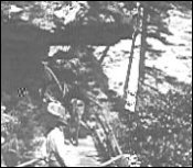
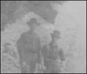
Click on these thumbnail photos to see the full-sized photos
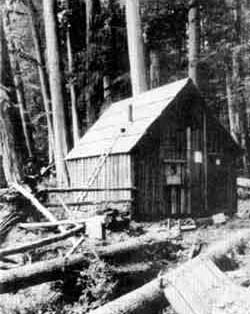
(Perley homestead)
(Skagit Gorge)
Far left. This photo shows one of the squatter cabins that the survey team would have encountered along the way up the Cascade River between Marblemount and Cascade Pass. The owner, J.T. Perley, operated the "Hotel Perley" along the Cascade River in the 1890s.Photo from the Callahan Collection, Seattle, Washington, courtesy of the National Parks Service.
Center: This photo was probably taken while looking up the river gorge east of what is now the town of Newhalem. Photo courtesy of Joyce Rickman, whose uncle, Milton Johnson, worked at the Skagit Queen Mine in 1906 and collected photos of the upper Skagit and various streams.

      Between July 22 and Sept. 11, 1895, engineer Bert Huntoon and WBSRC commissioners E.M Wilson, R.O. Welts, and J. Howard Watson surveyed almost 500 miles of the North Cascades. Whenever possible the group followed trails established earlier by Indians and miners, but they were also often forced to open new trails along most of the Rainy Pass route and the Thunder Creek route [WBSRC, page 1]. They recorded barometric altitudes and profiles, elevations of six mountain passes and distances between major points and the resulting map of the mountains showed natural features, the streams and their true courses, and names of the settlers along the way and the locations of their cabins encountered along the way. The commissioners noted that the map was most valuable because the prior federal and state maps of this section were "woefully erroneous and misleading."
      The group departed from Marblemount [then called Marble Mount], where they rented horses and pack outfits for their trip. They examined the Slate Creek route first. The trail ran for 17 miles through forest and along the Skagit River, over a fairly-level country. At mile ten, they discovered the "Devil's Dream," a trail in front of a rock wall across rude bridges on the cliff above the river. After that, the trail followed level bottom land until mile 17. At that point, they found the Skagit Canyon and rapids, after which the trail passed along a very high rock bluff to the site of the old Goat Trail bridge, which washed away in the floods of 1894. That old trail extended two and a half miles to Cedar Bar, the site of the Davis-family homestead.
      JoAnn Roe researched that part of the Goat Trial for her 1997 book, North Cascades Highway:

      Just two routes awaited the incoming prospector: the foot trail to Ruby Creek over the dangerously narrow ledge trail through the Skagit Gorge, impassable for pack stock at first, or the Nooksack Trail from Bellingham to Hope and back south on the Skagit River. Miners entering the Cascade Pass area went up the Cascade River and veered off toward Thunder Creek or came from the Skagit Gorge. . . . The miner's easy approach ended and he was faced with the awful gorge. One scoundrel, a Captain Randolph, built a house across a narrow portion of the trail, demanding a toll to pass through. Randolph and his structure mysteriously disappeared, though. . . . A particularly bad point in the trail was at Devil's Corner. . . . later dubbed Devil's Elbow), a ledge that lies directly above Tunnel No. 1 on today's highway; an overhanging rock there required a series of ladders to enable prospectors to pass.
      Until a few days before the State surveyors arrived in 1895, the trail could only be followed on foot, using a ladder to scale the most difficult points. But in that spring, miners blasted half tunnels through perpendicular cliffs and constructed rude bridges across chasms. By the time that the surveyors arrived, light horses could be ridden along the trail but the grades in some places were excessive, so only the lightest ponies were allowed [WBSRC, page 3-4]. Author and upriver pioneer Will D. Jenkins described the Goat Trail in his 1984 book, Last Frontier in the North Cascades,
      . . . Goat Trail, that's where the wild gorge of the Skagit begins, just beyond the flat where the hydro village of Newhalem now stands. It took two days to cover those first fourŽteen miles [from Marblemount], but they were the easy ones, favored by fairly level ground along the SkagŽit's banks beyond Bacon Creek, to the big flat country around Old Man Thornton's homestead and Gus Dohne's road-house at Goodell Creek.
      But the Goat Trail was something else! Where you entered the gorge you followed about two hundred feet of what stretched out as evidence of an early-day contractor's hopeŽlessly abandoned attempt to build a road. This piece of "road" was about eight feet wide. It ended abruptly against the foot of a mammoth rock slide, and some of the chunks of granite that had rolled down from the high escarpments of the Cascades were as big as boxcars. Here began the path Ruby Creek's early prospectors had dubbed "The Goat Trail." It twisted and staggered among those mammoth chunks of broken rock in a tortuŽous route under overhanging snowfields that frequently sent down tons of avalanching ice, rock, and trees to roar into the foaming Skagit.

      From Stetattle Creek, near Cedar Bar, the party continued upriver about three miles to the junction at the "old Thunder Creek bridge," where that route branched off. Continuing up the main river trail, the party climbed around Sourdough Mountain noting: "this climb being necessary as the Skagit River here runs in a rock canyon where road building is impossible without extraordinary expense." The surveyors determined that the only route for a wagon road in this area would require dropping down to the Skagit River at the mouth of Ruby Creek after crossing Sourdough Mountain. That is where the Skagit Queen Mine [see this Journal website] was created in 1906.

Click on these thumbnail photos to see the full-sized photos
(Devil's Elbow 1)
(Devil's Elbow 2)
Center left: This photo of Devil's Elbow, courtesy of Joyce Rickman, was also taken by or of her uncle, Milton Johnson, who worked at the Skagit Queen Mine in 1906. Although it is considerably faded, the photo shows details of how the tunnel was chiseled from the cliff above the Skagit.
Upper left. This is a photo of the Devil's Corner or Devil's Elbow, which was on the Goat Trail, a path that miners carved by hand from The Portage, downriver from Newhalem, to the gold fields on Ruby creek, starting in 1878. The path was chiseled out of granite to form a path along the steep walls of the gorge above what we now call Newhalem. From The Portage, the last point to which canoes could navigate upriver, all supplies had to be carried on the backs of miners or mules. Until Will D. Jenkins and others were hired to use dynamite to widen the trails about 30 years later, the Devil's Corner was typical of the switchbacks and abrupt turns on the trails. This photo was probably taken by Darius Kinsey, in 1903, the same year as the Skagit County Times article below.

Second leg in the Methow Valley
      From the junction of the Methow and Twisp Rivers the party embarked on the second leg of their assignment, which would return them to Marblemount via Cascade Pass. They followed the Methow River to the confluence of the "Twitsp" [later named Twisp] River, crossing that one to the north side and followed an established trail that dropped down to the confluence of Bridge Creek and the Stehekin River. Back in 1893, Frank Wilkeson — veteran of the 1870 Northern Pacific survey of the Skagit, homesteaded land near the confluence and opened a mining store and small hotel in 1893, with his son Bayard and his daughter-in-law Evelyn as managers. At first, the Chelan Leader reported, they were "rushed with business." By 1895, however, the nationwide Depression had apparently taken the bloom off the rose, as they said back then. According to Frank's biographer, Patricia McAndrew, his interests and time had shifted to irrigation sites in eastern Washington. Miners hiking in around the time of the State Survey reported that the buildings were abandoned, even though they were well placed on what was considered the most natural route for the wagon road. We learned from Evelyn's 1954 obituary that the couple hiked out in June 1895, with Evelyn carrying her three-year-old daughter in her back. After crossing the pass, they wound up at Frank's ranch at Hamilton and she is considered to be the first white woman to cross the pass.
      The surveyors hiked along the Stehekin for seven miles to Pershall's cabin and then to the head of the Stehekin, where a "stiff climb" of two and a half miles took them to elevation 5,392 feet at Cascade Pass. They observed that the pass "has an icy appearance even in summer as the glaciers [Johannesburg Glacier] hug it close and snow remains in the shady side of the pass generally all the summer" [WBSRC, page 7].
      From Cascade Pass the surveyors proceeded down the western slope of the ridge, noting that "the old trail is down a very steep slope and decidedly uninviting, no perceptible work even [sic] having been done on it" [WBSRC, page 8.]. Within two and a half miles the party reached a cabin on the Cascade River that was built by Gilbert Landre, an early settler and miner in the region who ran a roadhouse in the backcountry. A French-Canadian immigrant, Landre first came to the North Cascades in about 1888, and built his first cabin near the junction of the north fork of the Cascade River and Cabin Creek, although he never actually filed for a homestead. Landre's informal resting spot was located at a key point for travelers both coming and going, west of what was called the "Stairway," the extremely steep southeastern face of Cascade pass. From Landre's cabin, the group followed a mostly level trail to Marblemount, about 20 miles.


Thunder Creek route
      The Thunder Creek route led the surveyors over Park Creek Pass. Retracing their steps along the Skagit River and the Goat Trail to where Thunder Creek joins the Skagit River, the party noted: "Thunder Creek here comes through a rocky gorge, a rare picture of beauty, but expensive from the road builders point of view. It empties into the Skagit River which here runs through a rocky canyon, and unless one stands directly in front of Thunder Creek its place of entrance into the river is hidden by the close towering walls [WBSRC, page 10]. From there they continued up Thunder Creek along an established miner's trail noting that "the route is easy, the present narrow trail being fairly well graded, but needing a great deal of work." At Mile 10 a tree" bridge redirected the trail across the creek where it then continued up toward Thunder Creek Pass (today's Park Creek Pass) following a steep slope with no prior trail. From the pass the party descended to Bridge Creek. Because they had already traversed the route along Bridge Creek to Twisp Pass, the men retraced their steps and returned to Marblemount.

Slate Creek Route
      The last route led the surveyors along the previously traveled Slate Creek route to Granite Creek. They began at Marblemount, hiked to Ruby Creek and crossed Rainy Pass, "along which a trail had never been even blazed," and then down Bridge Creek to State Creek, up State Creek to Washington Pass, and then down Early Winters Creek to the Methow River Valley [WBSRC, page 12-13.]. Except for the initial part, that route led the surveyors outside the boundaries of today's park and along part of the eventual route of today's Hwy 20.
      The commissioners published their findings in an 1896 report. Unnamed photographers recorded scenes along the Skagit River and Ruby Creek on the four routes. They also photographed the "approach to Devil's Corner," the footbridge visible and accessible today, and Devil's Corner itself, which is not accessible. Apparently impressed by the ingenuity of miners, the commissioners elaborated on their efforts:

      [the] Goat trail is truly picturesque and shows the energy displayed by the active interests of the Slate Creek mining district in opening a way of ingress and egress. There is considerable of this [photo depicting a trail beneath a rock overhang] which is built in the most available places without regard to grades and the roof just high enough for pack horses to pass under safely [WBSRC, page 8.].
      The Board determined from the report that "the route up the Twitsp [sic] River, over Twitsp Pass, down Bridge Creek, up the Stehekin River, over Cascade . . . Pass and down the Cascade River the shortest and the most feasible and practicable." [WBSRC, page 15.] In the spring of 1896, the state hired a foremen and laborers who were to construct a road forty feet wide. On the east side of the mountains, Stehekin Valley settler Merritt Field contracted with the state to operate boarding houses for the laborers on lower Bridge Creek and Stehekin. The road crew was able to construct a road from Stehekin to Bridge Creek that ran past Coon Lake. A later mine-to-market road was built from Bridge Creek to Horseshoe Basin in the 1940s. The 1896 road to Bridge Creek was plagued with logs strewn across it and large rocks that were never removed, so it was subsequently never used as a wagon road, as planned. Today, portions of this route have become a hiking trail within the national park, and some valley residents contend the early road can still be followed in its entirety, despite the vegetation that has grown over it.
      In 1896, a road on the west side was built twelve miles up the Cascade River from the west, but that road was never completed across Cascade Pass, either. Ironically, the road that was eventually named the North Cross-State Highway, and then the North Cascades Highway, followed the northern route that the commissioners originally dismissed as the longest and "the most expensive part of the Slate Creek route." [WBSRC, page 14.]


Endnotes
      Below you will find annotations from the links above that will provide more background information. We hope that a reader will have family memories and copies of photos to share that concern these early pioneers, the trails and roads and the early pack trips across Cascade Pass. And we plan to expand this section quite a bit, so please mail us copies of any historical articles about Cascade Pass, the wagon road and Highway 20.

Washington Board of State Road Commissioners
      Records 1895-1896. Washington State Library Manuscripts, Olympia, Washington: 1896, p.2. [Return]

Gretchen A. Luxenberg
      Gretchen A. Luxenberg, Author, Cultural Resources Division, Recreation Resources and Professional Services, Pacific Northwest Region, National Park Service, Department of the Interior, 1986. We wrote much of this section based on her report, which is well worth reading in full. [Return]

Robert Byrd
      Byrd's extensive writing has helped us understand the layout of Lake Chelan, the Stehekin River and the mountains. We never met him but thanks to Fred Pflugrath of Chelan, we learned a lot about him. From Byrd's Aug. 22, 1989, obituary in the Wenatchee World, we learned that "he was born May 8, 1925, at Chelan to Charles and Dorothy Byrd. His parents homesteaded in the Stehekin Valley and he was raised there, attending a one-room log school, which his father helped construct, through the eighth grade. The family then moved to Wenatchee and he graduated from Wenatchee High School in 1943. He later graduated from Multnomah School of the Bible in Portland."
      Byrd's grandmother was Mamie Moore, the daughter of James (John) Robert Moore, who came to Chelan in 1890 from New York, where his family owned hotels for 60 years. He built the first hotel on upper Lake Chelan, on his property at the mouth of Fish Creek — six miles south of the head of the lake, a site later named Moore's Point. He added a large three-story addition during the winter of 1891-92 to accommodate the huge influx of prospectors, visitors and settlers who were moving into the area almost weekly. One of Moore's ancestors was Roger Sherman, who helped draft both the Declaration of Independence and the Constitution.
      After logging in Oregon and Washington, Byrd and his wife, Hilda, returned to Lake Chelan and he started commercial rubber raft float trips on the Stehekin River and the first shuttle bus service in the Stehekin Valley, after which he was the concessionaire for the National Park Service from 1972-77. He was a photographer and writer and wrote the "Stehekin Diary" for The Wenatchee World newspaper from 1969 to 1971. For a short time he put out a small paper of his own called "A Voice in the Stehekin Wilderness" and he wrote and published Lake Chelan in the 1890s in 1972. He also became disillusioned with his work for the Parks Service and became a very vocal critic of the regulations and bureaucratic red tape.
      Update 2008: Read our review of Byrd's Lake Chelan in the 1890s book, which was reprinted by his daughters. [Return]


Hiram Martin Chittenden
      If his name sounds familiar, that may be because of his namesake Hiram M. Chittenden Locks at Ballard that link the Sound and Salmon Bay. He was well known throughout the west for his engineering achievements, including surveying in Yellowstone National Park, preparing the way for flood control in the Missouri Valley, and serving as one of the first Port of Seattle commissioners. Chittenden was well regarded throughout the west for his engineering achievements, even before he served as one of the first Port of Seattle commissioners. As a U.S. Army engineer he surveyed Yellowstone National Park and published his book about the experience, Yellowstone National Park, in 1895. He also prepared the way for flood control in the Missouri Valley, studied the fur trade in Washington state and then took charge of U.S. Army Corps of Engineers in Seattle in 1906. He took over the Lake Washington Ship Canal project and, although he was forced by to retire in 1908 because of ill health, his work at organizing the project led to Congressional appropriation of more than the $2 million in 1910. The Locks opened on July 4, 1917; he died that year. The canal opened in 1934. His 1902 book, The American Fur Trade of the Far West, was the standard work on the subject for 50 years, as was his Yellowstone book. You can read more about Chittenden's conclusions about the fur trade at this National Parks Service website. [Return]

Variations on the Twisp name
      Twisp, as the small town on the Methow is now named, had a couple of different variations in the early days. The unusual-sounding name resulted from onomatopoeia by the local Indians who imitated the sound of a buzzing wasp or yellowjacket, which appear profusely in late summer. Sally Portman wrote that Indians first called the area Twistsp and then white settlers named the village T-wapsp in the Chinook jargon trade language. [Return]

Frank Wilkeson and family
      Patricia McAndrew and I have been researching Frank and his family in some depth for the past five years. Her collection of Frank's fishing stories from the New York Times, the book, The Old Soldier Goes Fishing, will be published in 2009, and I wrote some of the introductory chapters concerning Washington state. You can read more about Frank and his family at this website.. [Return]

Pershall's cabin
      Robert Pershall was an early Stehekin Valley settler and miner. You can read more about him at this National Parks Service history website. He and his brothers, Lloyd, and Al mined in Horseshoe Basin in the early 1890s, owned a general store together in Chelan, as well as a cottonwood fruit-box factory in Stehekin in 1896. Robert's owned two ranches in 1895; he and his wife wintered at Stehekin but his main property (also sometimes called the Perry Wilcox ranch) was nearly miles seven miles up valley from the head of Lake Chelan, prior to when the area was flooded for the subsequent dam project. [Return]

Gilbert Landre
      You can learn more about Landre and his landmark cabin at this Journal website. Marblemount pioneer Frank E. Davis wrote that he first encountered Landre while packing for surveyor J.C. Parsons in 1893, and saw him building his first cabin, which caved in under snowfall the next year. Landre rebuilt the cabin and added a second half-story in time for the 1895 group to store many of their logging and packing tools there while hiking back and forth across the pass. Birdsview pioneer Otto Pressentin, who was a schoolteacher as well as a very rugged outdoorsmen, wrote that he visited Landre often and read and wrote letters for the immigrant since he was illiterate in English. Landre died intestate in 1905 and Otto's brother Paul was named his executor. Hikers and miners used the cabin through the World War II years, but it continued to deteriorate and was thought at one time to have disappeared. When survey teams traveled through the area in 1968 as they worked on the proposed route for the North Cross-State Highway, they discovered that the walls were still standing even though the roof had caved in sometime before. Dr. Jesse Kennedy, director of the North Cascades National Park Marblemount curation facility reports that the remaining wallboards are crumbling, and Concrete resident Jim Harris also reports the same condition. The pass itself is 21 miles from Marblemount and Kennedy points out that the gravel road ends about a mile short of the cabin. [Return]

Merritt Field
      Field was one of the two most famed hoteliers of Lake Chelan, along with his downlake neighbor, John Moore. He arrived in 1892 and managed and then soon bought a small wood building, at the head of the lake, in which George Hall operated a hotel that he called the Argonaut. Field continued operating the hotel and in 1893 he married and brought his new wife uplake to help run the business. By the time the road crews arrived in 1896, the Fields ran both the hotel and the boarding houses. By 1902, when Field's property was surveyed for homestead entry, the hotel had grown to 25 rooms erected with timber that Field cut from his claim between 1890-1894 and 1898-1901. Field's hotel venture was so successful and the demand for reservations was so great that he built a large and picturesque structure in 1905 that could accommodate one hundred guests overnight. The old Argonaut was the kernel and the new complex became known as the Field Hotel, a first-class hospitality center that catered to both miners and tourists by offering good food, boating on the lake, backcountry guide service, horse pack-trains, and many other services. Concurrent with the hotel operation, Field also engaged in the shingle business and in mining, and served as Stehekin's first postmaster. He moved to Chelan after his land was flooded for a subsequent hydroelectric dam. [Return]

The Goat Trail
Skagit County Times, Sedro-Woolley, April 2, 1903
      Far from the busy haunts of men, way up the picturesque valley of the sometimes placid and anon restless Skagit, are many scenes of surŽpassing natural beauty and delightful effect. Starting from Sedro-Woolley, the gateway to the great timber and mineral country to the east and north,. the traveler in search of business, sport or health must perforce follow the deŽvious course of the grand old river which has for centuries flowed down to the sea over rugged precipices, by vast forests of giant trees and along virgin valleys of wonderful possibilities.
      Perhaps in no other region of like exŽtent on the Pacific slope has nature been so lavish in her gifts of wealth and beauty. To reach the famous Slate Creek gold fields, on the western slope of the Cascade mountains, it is necesŽsary to traverse the perilous and weariŽsome Goat Trail, a rough and narrow pathway over precipitous cliffs and yawning chasms that every moment threaten the life of the venturesome traveler. Although less than ten miles long this trail is pronounced by the hardiest old prospectors to be about the "toughest bit of hiking on earth."
      Some seven miles along Goat Trail is the Devil's Corner, one of the most inŽteresting and romantic of the upriver beauty spots. The Devil's Corner is said to have received its name from the circumstance that the Ruby Creek Mining Company, in underŽtaking to repair and shorten the trail down the river, found this particular learner a "devil" of a hard place to get around.
      The illustration shows that a portion of the solid mountain of granite has been blasted out to make room for the trail, leaving overhead an awning of natural rock of thousands of tons in weight. The other side of the pathway is bordered by the top of the deep and narrow canyon through which the waters of the Skagit dash and foam in their contracted bed a hundred feet below.


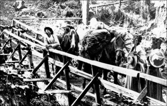
(Goat Trail)
      This was a typical wooden bridge over the high county canyons. This photo was taken by Darius Kinsey 1903. His wife, Tabitha, and her friend, Miss Phronia Farnsworth, are at the right. Packer Ed Barnes is at the left. The horse at the rear carries three of Kinsey's camera cases. You can see the photo and read the story about the ascent in the excellent book, Kinsey, Photographer, on pages 112-19

The Devil's Elbow
Last Frontier in the North Cascades, Will D. "Bob" Jenkins, 1984
      A short distance above the present village of Newhalem the first of three highway tunnels pierces the solid bedrock of the Skagit canŽyon. Traffic speeds through this hole in the mountain where once the trail hung precariŽously against a cliff with a vertical face to the river's boiling white water. A portion of the trail's dizzy passageway was suspended on the scaffolding of small poles and cedar punŽcheon and a few eye bolts drilled into the granite to which supporting cables were clamped.
      This place was known as The Devil's Elbow, or sometimes it was called Devil's Corner. Passing up-river, you came to the Elbow and some of the most rugged trail the Northwest has ever known; crooked, winding, often steep as it twisted among huge chunks of granite the ages had tossed into the Skagit gorge from high and snow-crested summits. And just before you came onto the actual bend of the Elbow, you crossed a sheer-sided chasm on fifty feet of puncheon footbridge which hung above the seething river.
      This little bridge, a vital link in the chain of miles known as The Goat Trail, was deŽstroyed by fire in June of 1919. The fire marooned the Gorge Creek camp of the Lynch Brothers' Diamond Drilling Company, conŽtaining more than fifty men, the Davis family at Cedar Bar, and the Forest Service crews on the Upper Skagit, all of whom depended on pack train supplies. I was stationed at the Bar that year and helped rebuild the bridge. The job was no small feat. The little span was still standing (forgotten and bypassed by the tunnel route) when last I visited some of my old haunts in 1970. The story of the reŽbuilding of the span should be of interest to anyone with an affection for mountain counŽtry trails and an appreciation for the labor of building them.
      Lynch Brothers were operating half a dozen drills in the Gorge Creek area. Cause of the fire was never actually proved, but two youths who had been discharged and compelled to make the long walk out to Marblemount on a warm summer day were suspected of firing the bridge to spite Dick Lynch, who had canned them for goldbricking on the job.
      Within two hours of their departure down-trail, smoke boiling up through the gorge caused general alarm in the camp and several in the crew got down to Devil's Elbow in time to see the flaming stringers collapse into the chasm of the Skagit.
      I had worked with Art Newby on Baker River in 1917 and the two of us were assigned by Ranger Tommy Thompson to rig a cable go-devil across the chasm. Windy Luke HenŽdrickson and a gang of helpers from the Lynch Brothers' camp set to work on a timbered flat a mile upstream, cutting out cedar stringers and puncheon for a new span.
      On the afternoon of the day of the fire, Newby scaled the face of the cliff above the chasm in a dizzy climb that required more than two hours to reach a point on the oppoŽsite ledge only fifty feet away. While Art climbed to gain the west side of the gorge, I single-jacked a drill hole into the bedrock on the up-river side for an eye bolt in which to anchor a length of half-inch cable. When Newby had inserted a similar bolt on his side of the gorge, I threw him a light line attached to the length of cable which he pulled across and shackled into his eye bolt. By dusk we at least had a means of emergency crossing: a cable on which was hung a pulley and a "bos'n's chair."
      Finding old-growth cedar of sufficient size to make good stringers fifty feet long was a problem but Windy eventually located two good trees which he broadaxed on the flat above Gorge Creek. I do not recall the number of days we spent on this project but it was less than a week, Dick Lynch giving us any and all help needed. Cedar puncheons were also cut on the flat. To move the fifty-foot stringers over a mile of steep and crooked trail was no small task. With ten to twelve men shouldering each of the heavy timbers, they were thus carried over the full distance, and at times it was necessary to rope the big sills to snub them around sharp bends or to drag them manually where the trail among the rocks was so crooked it was impossible to shoulder the heavy timbers.
      In like fashion the thick cedar puncheons were transported from the flat to the new span, Lynch's men carrying the big slabs one at a time, shoulders padded with gunny sacks.
      The go-devil was used to haul the stringers into position and the day the last of the punŽcheons was spiked down Herman Rohde's pack-train of twenty mules loaded with drill rods and other hardware and grub for the Gorge Creek crew crossed in the late afterŽnoon.
      I'll never forget how Herman's old lead mule, Monk, paused and sniffed at the bright deck of the new bridge and tested the punŽcheon with a sharp shod front foot, and then stepped along, the balance of the train folŽlowing and snorting at the pungent scent of the newly split cedar. The narrow span had no rails as yet and the Skagit boiled white and noisy below, but that was of little concern to Rohde's mules. They could walk a foot-log if necessary, and sometimes did.


Links, background reading and sources

Story posted on Dec. 23, 2005, last updated Jan. 12, 2009
Please report any broken links so we can update them
This article originally appeared in Issue 31 of our Subscribers-paid Journal online magazine


Return to the new-domain home page
Links for portals to subjects and towns
Newest photo features
Search entire site
(bullet) See this Journal website for a timeline of local, state, national, international events for years of the pioneer period.
(bullet) Did you enjoy this story? Remember, as with all our features, this story is a draft and will evolve as we discover more information and photos. This process continues until we eventually compile a book about Northwest history. Can you help?
(bullet) Remember; we welcome correction & criticism.
(bullet) Please report any broken links or files that do not open and we will send you the correct link. With more than 550 features, we depend on your report. Thank you.
(bullet) Read about how you can order CDs that include our photo features from the first five years of our Subscribers Edition. Perfect for gifts.

You can click the donation button to contribute to the rising costs of this site. You can also subscribe to our optional Subscribers-Paid Journal magazine online, which has entered its seventh year with exclusive stories, in-depth research and photos that are shared with our subscribers first. You can go here to read the preview edition to see examples of our in-depth research or read how and why to subscribe.

You can read the history websites about our prime sponsors
Would you like information about how to join them?

(bullet) Oliver-Hammer Clothes Shop at 817 Metcalf Street in downtown Sedro-Woolley, 86 years.
(bullet) Peace and quiet at the Alpine RV Park, just north of Marblemount on Hwy 20, day, week or month, perfect for hunting or fishing
Park your RV or pitch a tent by the Skagit River, just a short drive from Winthrop or Sedro-Woolley

(bullet) Joy's Sedro-Woolley Bakery-Cafe at 823 Metcalf Street in downtown Sedro-Woolley.
(bullet) Check out Sedro-Woolley First section for links to all stories and reasons to shop here first
or make this your destination on your visit or vacation.
(bullet) Are you looking to buy or sell a historic property, business or residence?
We may be able to assist. Email us for details.
Looking for something special on our site? Enter name, town or subject, then press "Find" Search this site powered by FreeFind
    Did you find what you were seeking? We have helped many people find individual names or places, so email if you have any difficulty.
    Tip: Put quotation marks around a specific name or item of two words or more, and then experiment with different combinations of the words without quote marks. We are currently researching some of the names most recently searched for — check the list here. Maybe you have searched for one of them?
Please sign our guestbook so our readers will know where you found out about us, or share something you know about the Skagit River or your memories or those of your family. Share your reactions or suggestions or comment on our Journal. Thank you for taking time out of your busy day to visit our site.

View My Guestbook
Sign My Guestbook
Email us at: skagitriverjournal@gmail.com
(Click to send email)
Mail copies/documents to Street address: Skagit River Journal, 810 Central Ave., Sedro-Woolley, WA, 98284.