Skagit River Journal
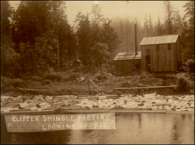
(Clipper Shingle Mill)
This photo of the Clipper Shingle Mill dates from the period circa 1900. Old timers may recall the old Clipper story. We are researching the old villages of Clipper and Van Zandt. We hope a reader will have family memories, copies of documents or copies or scans of photos to share. We never ask for your originals. Please email. Photo courtesy of Geneva Ensign.
of History & Folklore
(bullet) Covering from British Columbia to Puget Sound. Washington counties covered: Skagit, Whatcom, Island, San Juan, Snohomish, focusing on Sedro-Woolley and Skagit Valley.
(bullet) This page originated in our Optional Subscribers Magazine


(bullet) An evolving history dedicated to committing random acts of historical kindness (bullet) The home pages remain free of any charge. We need donations or subscriptions to continue.
(bullet) Please pass on this website link to your family, relatives, friends and clients.

(bullet) Site founded Sept. 1, 2000. Passed 6 million page views, November 2012; passed 800 stories in 2012 — Mailing: (bullet) Noel V. Bourasaw, editor (bullet) 810 Central Ave., Sedro-Woolley, Washington, 98284 where Mortimer Cook started a town & named it Bug
(Click to send email)
or Search site

Alfred Downing sketches the 1880s river expeditions
Part Two of the 1882 Pierce expedition of the Skagit river

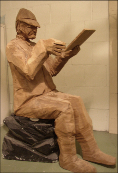
(Downing statue)
    When we inquired, Tammy Moad and Mark Behler, curator of the Wenatchee Valley Museum & Cultural Center found the 1988 wooden statue of Alfred Downing by Richard Beyer (which we explain below). Behler explained:

    "This is Beyer's Downing. He sits 61" tall, 23½", wide, 43" deep. He sits on a black painted Styrofoam "rock". The wood tablet is separate and sets in his left hand. He used to have a wood carved "writing/drawing device" in his right hand which is no longer around.
    Articles in The Confluence, Vol. 5, No. 1, Spring 1988, doesn't mention the Downing piece, but was part of the Coyote grouping. The layout of the exhibit shows the placement of Downing and the Coyote and Salmon. The stern of the bateau points at Downing. Downing sat by himself.
    Richard didn't think the wood sculptures would last very long. He thought they would crack and split beyond use. He didn't think they would be worth keeping once the exhibit ended. A few breaks did occur with the salmon and, if you look close, dowels can be spotted."


By Noel V. Bourasaw, Skagit River Journal ©2013
      Alfred Downing's sketches that he drew while an assistant on surveys of Washington Territory rivers have begun showing up from different sources old and new. We intended to profile Alfred Downing a few years ago but we found little information about him. In the past year some sources have surfaced; the most important being Jack Nisbet, an author of history and such who lives east of the Cascades. The most important and comprehensive source is Nisbet's "Boundaries Column" that he entitled, "Sketching the New World: The Art of Alfred Downing.
    Any time, any amount, please help build our travel and research fund for what promises to be a very busy 2013-14, traveling to mine resources from California to Washington and maybe beyond. Depth of research determined by the level of aid from readers. Because of our recent illness, our research fund is completely bare. See many examples of how you can aid our project and help us continue for another ten years. And subscriptions to our optional Subscribers Online Magazine (launched 2000) by donation too. Thank you.
      Nesbit explained that the early 1880s marked a key period of transition in Northwest history. White settlers began moving up the Columbia and tribal people were relocated onto lands designated by 1850s treaties as reservations, which were vastly inferior land that white settlers deemed relatively worthless. The Colville reservation was an example.
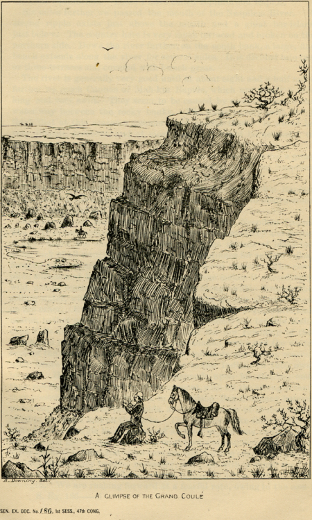
      When the U.S. Army organized expeditions to explore some of the major rivers, Alfred Downing was included in the expedition teams as a "topographical assistant" from 1880-84. His role evolved part time into a "sketch artist," of the scenes you see on these pages. After finding some of them a century later, Nisbet described them as,

      . . . faintly colored, fragile sketches that depicted people on the move in a vast but increasingly settled landscape. . . .
      Downing was born in England in 1848, and immigrated to the U.S. at the age of 24.

      That unfortunately is as much solid information we know about his genealogy.
      Early on he met an Army engineer his age, Lieutenant Thomas W. Symons, who later became his boss as they surveyed their way around the Columbia Basin. After a brief 1880 journey, they explored from the Snake River to the Canadian Border in 1881. In 1882 Downing joined the Pierce Expedition. Nisbet explains Downing's method:

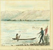
      During all this time, Downing made sketches of the land around him, and each one relates a direct experience in the North Columbia country. He usually worked with a simple pen or pencil, sometimes on blue-lined paper torn from issued journals. He occasionally found time to add colored ink or wash portions of his art with watercolors. One small cartoon shows a bedraggled Downing wandering the Columbia shore below Rock Island Rapids, where he had dumped his boat and drifted downstream from his party. Carrying a red flag as a signal, he tries to communicate with a tribal member who has pulled over to help. The canoe is a classic Plateau dugout, slender and seaworthy; the vast expanse of lonely river north of Vantage stretches to a line of fine riparian on the opposite shore. Downing himself, stepping around what looks like a stubby willow, extends his watch as an offering in exchange for some much-needed food. Speech balloons show the combination of Salish or Chinook jargon and English that the two men use to come to an agreement.
(Downing Sketch of Columbia)
Downing's sketch named "Examination of Upper Columbia River, 1882." Photo courtesy of William Layman

      Gretchen Luxenberg adds:
      Alfred Downing was no museum artist, and he never seemed to quite get beyond the first stage or two of finishing his field sketches. But he had an eye for detail, and a knack for capturing a moment on the fly. His work describes a real place, both familiar and very different from what we see with our own eyes, and that's makes it so valuable to us today.
      Years after he had first seen one of Downing's original works, Nisbet returned to the Northwest Room of the Spokane Library and marveled at how well the fragile sketches were stored and maintained in their home:
      I must not have studied it long. I recall being surprised at how small the sketch was, and delighting in its soft colors. But as far as any title, subject, or details of landscape were concerned, I left them in the vault. Since that encounter with Alfred Downing in the Northwest Room, I have returned to his sketches every once in a while because, as it turns out, they provide accurate glimpses of the Interior Columbia landscape just before the rise of our modern towns. . . . The next afternoon I was back at the library, looking over her shoulder at a beautifully textured piece of linen paper glued to a piece of mat board; together, they showed 130 years worth of tatters, wrinkles, and smudge marks. The sketch is titled "Old Fort Colville W.T. August 1882," and glows like an ancient charm.
      Following the Pierce expedition, Downing in 1883 toured north-central Washington to prepare for the planned farewell visit of the Northwest by retiring General William Tecumseh Sherman. In 1884 Downing patrolled the Colville Reservation with the local Indian agent to select mill sites for the Moses tribe.

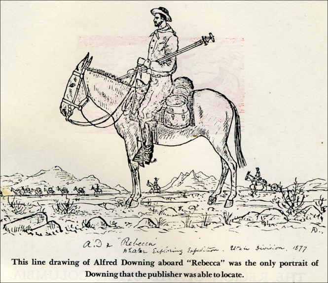
(Downing sketch of upper Columbia river)
The Region of the Upper Columbia As I Saw It," Downing's Self Portrait, 1877. Courtesy of William Layman.

      Then, for the next eight decades Downing seems to have largely escaped the public record. We know from brief notations that he lived in Portland and Seattle at various times, but we still do not know his ultimate profession or the date of his marriage or death. We found the black and white sketches on this page because Alfred's late daughter Inez loaned them for a November 17, 1946, Seattle Times article, transcribed in Issue 60 of the Journal magazine. [11] Inez Downing was born on Apr 9, 1903, and died in June 1969, but that is all we know about her. We continue searching and we encourage readers to share any information they may have about her, Alfred and the Downing family.
      Wenatchee feted Downing publicly in 1988 when famed Seattle and Pateros sculptor, the late Richard Beyer, hand delivered a collection of "large cedar sculptures of salmon, a coyote and cartographer Alfred Downing were roped down in the bed of a red 1978 Ford pickup." The sculptures will be displayed at the North Central Washington Museum." [12]


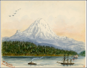
(Mount Rainer)
Mount Rainier from Seattle, by Alfred Downing
(Downing's Rock Island sketch)
"I Signal an Indian from Opposite Shore" by Alfred Downing, Rock Island 1880.
Far left. Art.com offers a high-quality Giclee print of this Downing sketch.
Center: See Dave Robertson's explanation of the sketch and the Chinook Jargon quoted on it. Copy of Sketch courtesy of Jack Nesbit, North Columbian Monthly of Colville.
Click on thumbnails for larger version.


The railroad dream across Cascade Pass stays alive
      Looking back now, we can see in hindsight that Rogers finally put to rest whatever thought Hill had for crossing Cascade Pass with his railroad venture. The buzz and chatter about such a route stayed alive, however, until the early 1890s, partly because it helped Hill keep the boomers at Anacortes and Fairhaven on the hook.
      You can read about the Fairhaven & Southern (F&S) Railway in our two part series [13]. This project is where the dream lived. Nelson Bennett, who helped construct Northern Pacific's [NP] transcontinental line over the plains and the mountains, bet most of what he made in NP bonuses on the F&S line, which would initially connect the coal mines near Sedro with the coal bunkers near Fairhaven. As Bennett built his 25-mile line in 1888-89, he had ambitious plans to extend it across the river to Seattle, and east from Sedro, along the north shore of the Skagit river, and over Cascade Pass to connect with Hill's line at Spokane Falls. The F&S crew lost access to the southerly route when the competing Seattle Lake Shore & Eastern began working the Lake McMurray bottleneck, literally overnight, under the noses of Bennett's field crew. Bennett seemed to see the writing on the wall and moved his base of operations to Tacoma. Charles X. Larrabee, the Montana silver magnate who financed much of Fairhaven and the F&S, took over the line and it eventually merged with Hill's program, with never a thought again of crossing Cascade pass.
      Bennett had not planned the Cascades route without considerable planning. In 1888, while he was still negotiating with the Fairhaven interests for the booty in lots that could be every lucrative, Bennett assigned civil engineer John J. Donovan to survey all the possible rail routes west from the Cascade foothills. Donovan explored routes to three potential termini: Bowman's Anacortes (actually Ship Harbor, the present San Juan Islands & International ferry connection); Samish Point — which Donovan praised; and Fairhaven. Bennett preferred Fairhaven because of the deeper harbor there; Samish Bay was much too shallow for the ships that would carry U.S. goods to the Orient. The partners believed that Ward's Pass in the North Cascades was also still feasible as a route for the Great Northern. Donovan explored the Cascades region with his Massachusetts classmate J.Q. Barlow, who would soon be associated with the Monte Cristo mines and the Everett and Monte Cristo Railway and was the namesake of Barlow Pass in that region.
      In a March 3, 1924, interview with the Bellingham Herald, Donovan recalled that Samuel Hill, son-in-law of J.J. Hill, told him the reason the Great Northern routed their railroad line through Everett to Seattle instead of Bellingham. Messrs. Hill selected the southern route because it was possible to build a switchback at Stevens Pass, while the northern route, which would have brought the railroad down the Skagit, afforded no such engineering possibility.


Continue on to Part Two of this story, focusing on the sketches of Alfred Downing and subsequent railroad
surveys of the Cascade Pass region.


Endnotes

11. November 17, 1946, Seattle Times article
      See our Journal transcription. [Return]

12. Richard Beyer statue
      See this 25 years ago — 1988Wenatchee World article.
      Once again Miss Serendipity visited just as we were going to press last month on Issue 60. The article above eventually led us to William Layman, author of Native River: The Mid-Columbia Remembered. He and I were both friends of Richard Beyer and his late wife, but Layman knew Richard and Downing wooden statue very well because Layman built the exhibit at the Wenatchee Valley Museum & Cultural Center back in 1988. He wrote and told us:

      I am the person who talked Rich Beyer into portraying Alfred Downing in cedar for the children's exhibit I curated in the 1980s. Downing is a fascinating figure; as you may know he accompanied Lt. Symons on a Reconnaissance of the Upper Columbia in 1881, sketching the first accurate maps of the various rapids and features of the river in a brief 8-day run as well as contributing several sketches of his trip.
      Later in 1885 he wrote an account of a rather harrowing experience he had after suffering from heat stroke crossing the Columbia Basin. He took a nap in a boat at Chelan Falls; the boat had no oars and he woke up drifting down the river in a rather helpless state. His boat capsized in Rock Island rapids where he was pulled from the river by an Indian and eventually he rejoined Symons near present day Tri-Cities. His account survived and Mike Lynch published an illustrated account with Ye Galleon press. He later in 1891 completed a much more detailed survey of the Columbia from the International Boundary to Rock Island rapids that is a marvel of cartographic recording.
      In building the exhibit, I asked Beyer to do another piece illustrating a myth of the Columbia and he volunteered to throw in a rendition of Downing in cedar. The museum still has it. I have a photograph of it but not a very good one as he is silhouetted. The museum still has the sculpture. here is another illustration done by downing showing him running Rock Island rapids which was published in a New York paper. We exhibited a copy of it as the illustration is held by a private party.

[Return]

13. Fairhaven & Southern projected routes
      See our two-part Journal profile of the line and how it crossed the Seattle Lake Shore & Eastern and the Seattle & Northern lines that crossed in Woolley and Sedro. [Return]

Links, background reading and sources

Story posted on Nov. 14, 2013
Please report any broken links so we can update them
This article originally appeared in Issue 60 of our Subscribers-paid Journal online magazine


Getting lost trying to navigate
or find stories on our site?
Read how to sort through our 800-plus stories.

See this Journal Timeline website of local, state, national, international events for years of the pioneer period.
Return to the new-domain home page
Links for portals to subjects and towns
Newest photo features
Search entire site
Our sometimes monthly column, Puget Sound Mail
Comments or ?s about this story? Sign into our Guestbook
(bullet) See this Journal Timeline website of local, state, national, international events for years of the pioneer period.
(bullet) Did you enjoy this story? Remember, as with all our features, this story is a draft and will evolve as we discover more information and photos. This process continues as we compile and collaborate on books about Northwest history. Can you help? And also remember; we welcome correction, criticism and additions to the record.
(bullet) Please report any broken links or files that do not open and we will send you the correct link. With more than 700 features, we depend on your report. Thank you.
(bullet) Read about how you can order CDs that include our photo features from the first ten years of our Subscribers Edition. Perfect for gifts. Will be completed over the winter of 2013-14.

You can click the donation button to contribute to the rising costs of this site. See many examples of how you can aid our project and help us continue for another ten years. You can also subscribe to our optional Subscribers-Paid Journal magazine online, which has entered its 13th year with exclusive stories, in-depth research and photos that are shared with our subscribers first. You can go here to read the preview edition to see examples of our in-depth research or read how and why to subscribe. Our research trips in 2013-14 depend on this income.
You can read the history websites about our prime sponsors
Would you like information about how to join them in advertising? We cannot emphasize how we need such support for our accelerated research journeys of 2013-14 for books and many more stories.

(bullet) We are advertising for sale by readers, two fine historical books. The first is Theodore Winthrop's The Canoe and the Saddle, NY, American Publishers (c. Ticknor & Fields, 1862), a second edition, published circa 1890. And the four-volume set of The History of Washington by Lancaster Pollard and Lloyd Spencer, 1937. Please inquire by email if you want more details or want to make an offer. Also inquire about other offerings or if you request a specific book.
(bullet) Our newest sponsor, Plumeria Bay, is based in Birdsview, just a short walk away from the Royal family's famous Stumpranch, and is your source for the finest down comforters, pillows, featherbeds & duvet covers and bed linens. Order directly from their website and learn more about this intriguing local business.
(bullet) Oliver-Hammer Clothes Shop at 817 Metcalf Street in downtown Sedro-Woolley, 88 years.
(bullet) Peace and quiet at the Alpine RV Park, just north of Marblemount on Hwy 20, day, week or month, perfect for hunting or fishing
Park your RV or pitch a tent by the Skagit River, just a short drive from Winthrop or Sedro-Woolley
(bullet) Check out Sedro-Woolley First section for links to all stories and reasons to shop here first
or make this your destination on your visit or vacation.
(bullet) Are you looking to buy or sell a historic property, business or residence?
We may be able to assist. Email us for details.


Looking for something special on our site? Enter name, town or subject, then press "Find" Search this site powered by FreeFind
    Did you find what you were seeking? We have helped many people find individual names or places, so email if you have any difficulty.
    Tip: Put quotation marks around a specific name or item of two words or more, and then experiment with different combinations of the words without quote marks. We are currently researching some of the names most recently searched for — check the list here. Maybe you have searched for one of them?
Please sign our guestbook so our readers will know where you found out about us, or share something you know about the Skagit River or your memories or those of your family. Share your reactions or suggestions or comment on our Journal. Thank you for taking time out of your busy day to visit our site. View and sign guestbook here
Email us at: skagitriverjournal@gmail.com
(Click to send email)
Mail copies/documents to Street address: Skagit River Journal, 810 Central Ave., Sedro-Woolley, WA, 98284.


var _gaq = _gaq || []; _gaq.push(['_setAccount', 'UA-33739537-1']); _gaq.push(['_trackPageview']); (function() { var ga = document.createElement('script'); ga.type = 'text/javascript'; ga.async = true; ga.src = ('https:' == document.location.protocol ? 'https://ssl' : 'http://www') + '.google-analytics.com/ga.js'; var s = document.getElementsByTagName('script')[0]; s.parentNode.insertBefore(ga, s); })();