|
of History & Folklore
600 of 700 total Free Home Page Stories & Photos
(Also see our Subscribers Magazine Sample)
The most in-depth, comprehensive site about the Skagit
Covers from British Columbia to Puget Sound. Counties covered: Skagit, Whatcom, Island, San Juan, Snohomish & BC. An evolving history dedicated to committing random acts of historical kindness
|
Noel V. Bourasaw, editor  810 Central Ave., Sedro-Woolley, Washington, 98284 810 Central Ave., Sedro-Woolley, Washington, 98284
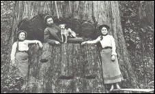
Home of the Tarheel Stomp Mortimer Cook slept here & named the town Bug
|

|
Site founded Sept. 1, 2000. We passed 5 million page views on June 6, 2011
The home pages remain free of any charge. We need donations or subscriptions to continue.
Please pass on this website link to your family, relatives, friends and clients.
|
Some statistics and research about Mount Baker
Undated Mount Vernon Herald article, 1949
If it weren't for the fact that the British edged out the Spaniards in the Pacific northwest the great peaks of the northern Cascades might be known to this day as "La Montana del Camelo," a far more poetic and imaginative name than the prosaic "Mount Baker" which has been its designation since 1792.
The adventurous seafarer Alferez Manuel Quimper was the first white man, as far as is known, to see the impressive peak looming up over the lower mountains and the San Juan islands. He spotted the peak from what he called Canal de Lopez de Haro (we call it Haro strait) in 1790. The Spanish name for the mountain has been freely translated as "The Great White Watcher."
|
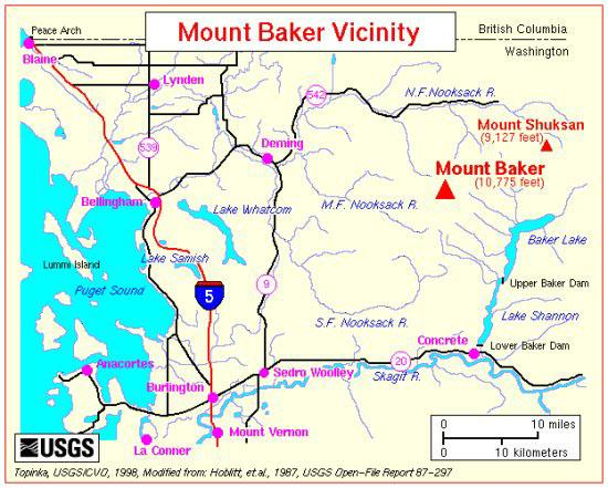
This USGS map is modified from: Hoblitt, et.al., 1987, USGS Open-File Report 87-297, and shows the location of Mount Baker compared to the entire Whatcom and Skagit counties.
|
Two years later, on April 30, a third lieutenant on the ship of Captain George Vancouver was startled to see the great, to him unknown, mountain looming up. In compliment to the officer who had spotted the peak, Joseph Baker, the mountain was given the name it has kept ever since.
The Indians, of course, named the peak long before any white man had seen it. Komo Kulshan, they called it. That has been translated: "the great white peak with the ends blown out," not as poetic as the Spaniard's fantasy, but surely the most accurate of the three names.
The stories which Vancouver's men brought back to England caused a talented British artist, Edmund T. Coleman, to leave his home and cast his lot with the settlers of the outpost of Victoria, on Vancouver Island, within sight of the mountain which fascinated the Englishman so much he made three expeditions up the rugged peak.
The first, in 1864 [actually in 1866, see endnote], ascended the Skagit river for about 50 miles where it was turned back by fear of hostile Indians. the next trip, [later] in 1866, made use of the easier Nooksack approach and the exploring party fought its way through the dense woods and up the rocky slopes to the perpetual ice fields, but stopped a scant 25 feet from its objective.
The "Roman wall" of sheer rock, blocked the way and Coleman didn't try going around the obstacle, apparently. Two years later [1868], he and his party made their way to the very summit and the account he wrote for Harper's [New Monthly magazine] the next year [November 1869, see endnote] was a classic description of the panorama spread out around the mighty peak.
Mount Baker in all its varied moods and lights, has thrilled beholders down through the years, but probably never since has the experience of three men been matched — the Spanish seafarer who first saw it, the third lieutenant in the British navy who gave the peak its name, and the London artist who wouldn't give up until he could see the awe-inspiring view from its forbidding summit.
Background of Mount Baker and statistics
From: Gardner, et.al., 1995, Potential Volcanic Hazards from Future Activity of
Mount Baker, Washington, USGS Open-File Report 95-498
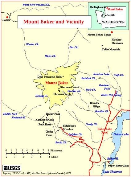 |
This USGS map is modified from: Hyde and Crandell, 1978, USGS Professional Paper 1022-C and shows a close-up of Mount Baker and its environs, including the Nooksack, Skagit and Baker rivers.
|
Mount Baker (3,285 meters; 10,778 feet) is an ice-clad volcano in the North Cascades of Washington State about 50 kilometers (31 miles) due east of the city of Bellingham. After Mount Rainier, it is the most heavily glaciated of the Cascade volcanoes: the volume of snow and ice on Mount Baker (about 1.8 cubic kilometers; 0.43 cubic miles) is greater than that of all the other Cascades volcanoes (except Rainier) combined. Isolated ridges of lava and hydrothermally altered rock, especially in the area of Sherman Crater, are exposed between glaciers on the upper flanks of the volcano: the lower flanks are steep and heavily vegetated. The volcano rests on a foundation of non-volcanic rocks in a region that is largely non-volcanic in origin.
The present-day cone is relatively young, perhaps less than 30,000 years old, but it sits atop a similar older volcanic cone called Black Buttes volcano which was active between 500,000 and 300,000 years ago. Much of Mount Baker's earlier geologic record was eroded away during the last ice age (which culminated 15,000- 20,000 years ago), by thick ice sheets that filled the valleys and covered much of the region. In the last 14,000 years, the area around the mountain has been largely ice free, but the mountain itself remains heavily mantled with snow and ice.
Deposits which record the last 14,000 years at Mount Baker indicate that Mount Baker has not had highly explosive eruptions like those of Mount St. Helens or Glacier Peak, nor has it erupted frequently. During this time period only four episodes of magmatic eruptive activity can be definitively recognized. Magmatic eruptions have produced tephra, pyroclastic flows, and lava flows from summit vents and from the Schriebers Meadow cinder cone. However, the most destructive and most frequent events at Mount Baker have been debris flows and debris avalanches, many, if not most, of which were not related to magmatic activity but may have been induced by steam emissions, earthquakes, heavy rainfall, or in some other way.
Historical activity at Mount Baker includes several explosions during the mid-19th century, which were witnessed from the Bellingham area, and since the late 1950s, numerous small-volume debris avalanches. In 1975, increased fumarolic activity in the Sherman Crater area caused concern that an eruption might be imminent. Additional monitoring equipment was installed and several geophysical surveys were conducted to try to detect the movement of magma. The level of Baker Lake was lowered and people were restricted from the area due to concerns that an eruption-induced debris avalanche or debris flow might enter Baker Lake and displace enough water to either cause a wave to overtop the Upper Baker Dam or cause complete failure of the dam. However, few anomalies other than the increased heat flow were recorded during the geophysical surveys nor were any other precursory activities observed to indicate that magma was moving up into the volcano. An increased level of fumarolic activity has continued at Mount Baker from 1975 to the present, but there are no other changes that suggest that magma movement is involved.
Links, background reading and sources
- See this Portal Section to Journal stories about Mount Baker and plenty of other links to sources about the mountain.
- Our Whatcom County portal section.
Story posted on April 21, 2005, last updated on Oct. 27, 2011
Please report any broken links so we can update them
Remember; we welcome correction & criticism.
Please report any broken links or files that do not open and we will send you the correct link. With more than 700 features, we depend on your report. Thank you. And do not give up if you find a link that seems to be closed. Just put the subject in the search box below. The story may have been moved to our new domain. Or just ask us and we will guide you to it.
Did you enjoy this story? Remember, as with all our features, this story is a draft and will evolve as we discover more information and photos. This process continues until we eventually compile a book about Northwest history. Can you help with copies or scans of documents or photos? We never ask for your originals.
Read about how you can order CDs that include our photo features from the first ten years of our Subscribers-paid online magazine. Perfect for gifts. Although it was delayed by our illness, it is due for completion in 2012.
|
You can click the donation button to contribute to the rising costs of this site. See many examples of how you can aid our project and help us continue for another ten years. You can also subscribe to our optional Subscribers-Paid Journal magazine online, which celebrated its tenth anniversary in September 2010, with exclusive stories, in-depth research and photos that are shared with our subscribers first. You can go here to read the preview edition to see examples of our in-depth research or read how and why to subscribe.
|
|
You can read the history websites about our prime sponsors
Would you like information about how to join them in advertising?
Our newest sponsor, Plumeria Bay, is based in Birdsview, just a short walk away from the Royal family's famous Stumpranch, and is your source for the finest down comforters, pillows, featherbeds andduvet covers and bed linens. Order directly from their website and learn more about this intriguing local business.
Oliver-Hammer Clothes Shop at 817 Metcalf Street in downtown Sedro-Woolley, 90 years continually in business.
Peace and quiet at the Alpine RV Park, just north of Marblemount on Hwy 20, day, week or month, perfect for hunting or fishing. Park your RV or pitch a tent — for as little as $5 per night — by the Skagit River, just a short drive from Winthrop or Sedro-Woolley. Alpine is doubling in capacity for RVs and camping in 2011.
Check out Sedro-Woolley First section for links to all stories and reasons to shop here first
or make this your destination on your visit or vacation.
Are you looking to buy or sell a historic property, business or residence?
We may be able to assist. Email us for details.
|
Did you find what you were seeking? We have helped many people find individual names or places, so email if you have any difficulty.
|
Tip: Put quotation marks around a specific name or item of two words or more, and then experiment with different combinations of the words without quote marks. We are currently researching some of the names most recently searched for — check the list here. Maybe you have searched for one of them?
|
Please sign our guestbook so our readers will know where you found out about us, or share something you know about the Skagit River or your memories or those of your family. Share your reactions or suggestions or comment on our Journal. Thank you for taking time out of your busy day to visit our site.
|

View My Guestbook
Sign My Guestbook
|
Email us at: skagitriverjournal@gmail.com

Mail copies/documents to Street address: Skagit River Journal, 810 Central Ave., Sedro-Woolley, WA, 98284.
|