(Girl Undercut)

Skagit River Journal

of History & Folklore
Subscribers Edition, where 450 of 700 stories originate
The most in-depth, comprehensive site about the Skagit

Covers from British Columbia to Puget Sound. Counties covered: Skagit, Whatcom, Island, San Juan, Snohomish & BC. An evolving history dedicated to committing random acts of historical kindness
Noel V. Bourasaw, editor (bullet) 810 Central Ave., Sedro-Woolley, Washington, 98284
Home of the Tarheel Stomp (bullet) Mortimer Cook slept here & named the town Bug

(Click to send email)
Site founded Sept. 1, 2000. We passed 5 million page views on June 6, 2011
The home pages remain free of any charge. We need donations or subscriptions to continue.
Please pass on this website link to your family, relatives, friends and clients.

Kunzler and Berentson launch website and
books with research of Skagit river floods


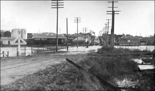
(Flood Mount Vernon 1921)
      Paul Dorpat, author of the Now and Then series in the Seattle Times and of several photo books, found this photo of the December 1921 floodwaters that were so widespread they even covered part of the Pacific Highway that is now Riverside drive in north Mount Vernon. We are looking south, up the hill towards where the Chuckwagon drive-in was later built. Fir street bisects in the center, behind the railroad tracks.

    Any time, any amount, please help build our travel and research fund for what promises to be a very busy 2011, traveling to mine resources from California to Washington and maybe beyond. Depth of research determined by the level of aid from readers. Because of our recent illness, our research fund is completely bare. See many examples of how you can aid our project and help us continue for another ten years. And subscriptions to our optional Subscribers Online Magazine (launched 2000) by donation too. Thank you.

      Back in 1994, ace history researcher Roger Peterson of Sedro-Woolley found a rare copy of the Skagit County Times from November 1896 that reported in depth the flood that year that inflicted severe damage on low-lying farmland from the upper reaches of the Skagit river down through Sedro-Woolley and especially the land around what was then called the Sterling Bend. The article in this issue about the flood damage is currently being used by Larry Kunzler to refute USGS's recent determination that the flood was not aggravated by a huge landslide on the Baker River..
      I met Larry ten years ago at the home of a mutual friend, Leonard Halverson, which is located just a stone's throw from what used to be called the Lower Ball's Riffle, and a couple hundred yards west of where Jesse Beriah Ball first located his logging camp in between the twin-horseshoe meanders that formed the Sterling Bend. They were both preparing for a trial and Larry had spent hours working with the Washington State Department of Natural Resources to painstakingly construct a map, ten feet wide, of the original 1866-84 surveys of all the sections lying north and south of the Skagit. Kunzler assembled the map in hopes that it would be exhibited at the courthouse to educate valley residents, and David Brookings, then the county's flood control division manager noted: "I think we'll use that map in the future. You look at some of the drainage problems we have today and you can look back and see why those areas are wet." Then as now, Kunzler noted that downriver dikes forced unnaturally high floodwaters onto property in the Sterling and Nookachamps/Clear Lake area during the floods of 1990..
      When we flash forward to the spring of 2005, Larry is still fighting with government agencies about Ole Man River and in March this year he launched a website in order to share the documents about the river and flooding that he has found over the years. He has studied ancient floods back to the one from Indian oral tradition that is placed in about 1815 through the floods of 1990 and 1995 and 2003 that inflicted so much damage again. He has found both amateur and professional river-depth postings over the past 150 years and has searched in many different libraries and dusty file cabinets for documents written by government officials as well as private citizens who watched in horror as the river ate away large chunks of their land. He also found personal accounts from families who moved themselves and their furniture up to attics and upper floors as the river rose and then had to be rescued by neighbors in boats or Indians in their cedar canoes.


Historical Newspaper Articles series
      Less than a year after the Veteran's Day and Thanksgiving Day floods of 1990, Kunzler published his first small book on floods, entitled Skagit River Valley, the Disaster Waiting to Happen. He extracted personal recollections, official reports, newspaper articles and books and photo collections regarding the floods. In that book he concluded:
      For the record I would like to state that the labor I have expended on the writing of this book has indeed been a labor of love. It is a fine line between dedication and obsession. Sometimes it is hard to tell the difference. having been a veteran of three flooding events (1975, 1979 and 1980), I know first hand the traumatic effects of floods and emotional scar that can leave you with. However, I also realize that we as mere mortals cannot stop the courses of nature. Trying to stop floods is like trying to stop Mt. Baker from erupting. All of our efforts in years past have only worsened the situation at hand. that old butter commercial that stated, "It's not nice to fool with mother nature" is very applicable to flood plains . . . .
      Putting dams on rivers has depleted our salmon runs to the point of extinction. Putting levees on the edge of rivers is like putting a time bomb next to your bed and going to sleep. There is no doubt that the Skagit river is a ticking time bomb and most importantly, a disaster waiting to happen. The only thing that we can control is how bad the disaster will be. If we continue to ignore mother nature by building irresponsible commercial and residential development in our flood plains, we are not part of the solution, we are part of the problem.


We are indebted to Larry Kunzler, a friend since 1992, for his expertise about floods. He and his son Josef have assembled a terrific website about the history of the Skagit river itself. They have shared their exceptionally deep research by posting dozens of pages of excerpts from the Concrete Herald about the river, attempts to corral it plus many more subjects.

      Flash forward again and Kunzler's original book has been followed up by two books published in limited editions earlier this year in partnership with Dan Berentson, the Communications Director/Community Liaison for Skagit county. Dan Berentson has a unique perspective, having published the Skagit Argus for 18 years and having reported on the 1990 and 1995 floods. I always enjoyed discussing Skagit history with Dan and appreciated his memories from his history publications and his role as president of the Pioneer Association of Skagit county. In his current position, his responsibilities include public outreach and participation in the Skagit River Flood Reduction Feasibility Study, and he serves as the county's Public Information Officer during flood events.

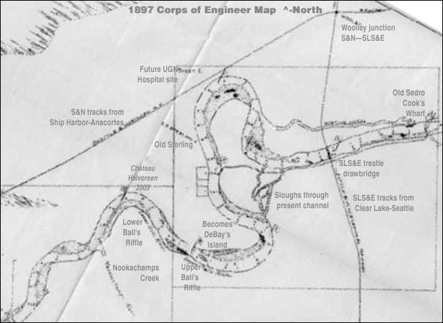
(Sterling bend)
      This map was drawn by the U.S. Army Corps of Engineers in 1897. Disastrous twin floods of 1897 and 1897 followed another earlier in 1894 and the Corps was investigating the possibilities of forcing a new channel of the Skagit river west of Sedro and southeast of old Sterling. You can see on the map that what is now Hart's slough was then the uppermost of a double horseshoe bend of the river. The southern horseshoe looped below Joseph DeBay's farm. After the river itself formed a shallow slough on a straighter course, Burlington farmers dynamited the channel north of DeBay's farm, with the new course eventually forming an island (DeBay's Island). The southern loop is now mostly a dry slough and DeBay's farm is now a wildlife refuge. You can also see, on the left (west) of the middle of the double bend, where Ball's original town of Sterling was. [Please excuse the typo of Halvorsen, which should be Halverson

      We strongly urge you to read their books, which are available at most libraries in the county and at the Sedro-Woolley Historical Museum. Volume 1 includes facsimiles of articles from the Burlington Journal and Mount Vernon Argus from years of 1909-69. Volume II includes articles from the Sedro-Woolley Courier-Times of 1904-51. Along with the articles that they cut and pasted, Kunzler and Berentson provide an exhaustive summary of each article that will be very useful to researchers of all kinds and especially those who live outside of the area but who remember the floods or want to get a handle on them and their aftermath.

Kunzler's wet introduction to the Skagit and "stilt-houses"
      Larry explains what led up to his 30-year campaign to educate others about the river:
      I moved to the beautiful Skagit Valley in 1971 after being discharged from the U. S. Navy. After growing up in South Florida, the Navy had stationed me on Whidbey Island in 1967 and the whole time I was overseas in exotic places like Okinawa, Philippines and Viet Nam, I thought only of moving back to Skagit Valley.
      When I said "back to Skagit Valley" , that was because, while being stationed at Whidbey Island, every weekend I and two other "sailors" would go camping up at Lake Diablo which obviously meant that we had to drive through Skagit County. Growing up on the beaches of Ft. Lauderdale, I had never seen such a pretty landscape. I had never seen mountains before, never went camping — the Everglades is not very user friendly. While I still miss the fishing and skin diving South Florida provides, it can never compare to the sense of oneness one feels while hiking in the North Cascades.
      On April Fools day 1975 I purchased my first piece of real estate. Fulfilling a boyhood dream of becoming a farmer I purchased a 20 acre farm in the Nookachamps Valley — known by local Indians as the Valley of the House of Stilts. When I asked the Realtor why the farmhouse sat six feet off the ground he replied, "It used to flood here, but now we have 5 dams on the river and it doesn't flood anymore. Eight months later I had 4 feet of water under my farmhouse and across my fields and in my barns. My property was located in the Nookachamps Valley along Francis Road between Mount Vernon and Clear Lake. During flood events — 1975, 1979 and 1980, it became part of the Skagit River. The flooding of the Nookachamps is a natural event which is aggravated by the Dike 12 and Dike 17 levees which back up the water during flood events from 4 feet at my old farmhouse to 0.5 feet at the Sedro-Woolley sewage treatment plant. Since I sold the farm it has had water inside the farmhouse which sits 6 feet off the ground on three occasions.
      Professionally, I have worked from everything from a loading dock freight handler, forklift driver, hired hand on a dairy farm, to being the lead investigator for one of the top 100 class-action attorneys in the country. It is the skills I have honed in the legal community that I have used to do the research on the Skagit River. They have served me — and I hope the community — well.
      I have spent the last 30 years, literally thousands of hours researching, documenting, reviewing and collecting anything and everything I could in search of the truth about the Skagit River Flood Issue. This web site is intended to share with anyone else interested in the truth about the history of this majestic river. Ultimately this site will contain many of the thousands of documents that I have obtained as well as the papers that I have authored over the years. It's been a labor of love for me.

      The fine website that Kunzler has assembled with the help of Josef Kunzler includes dozens of articles and papers about the river and the floods, most in PDF format. A number of them date from the 1924 period, three years after the 1921 flood, which was the worst for damage since the twin floods of 1896 and 1897. Those documents from that year include the report by the controversial government researcher, James E. Stewart — which we will soon discuss in depth in a separate article — another by Robert E.L. Knapp, Skagit County Engineer, and two by J.O. Rudene, the legendary farmer from Pleasant Ridge, and H.L. Willis, Skagit River Improvement Committee Chairman. Other linked reports include the 1911 Clapp Report, issued after the ravaging 1909 flood, through reports from the early 1950s about the floods of 1949 and 1951 that sent many farmers and city slickers to their rowboats.

Links, background reading and sources

Story posted on March 25, 2005, moved to this domain Jan. 15, 2011
Please report any broken links so we can update them


Getting lost trying to navigate
or find stories on our site?
Read how to sort through our 700-plus stories.

See this Journal Timeline website of local, state, national, international events for years of the pioneer period.
Return to the new-domain home page
Links for portals to subjects and towns
Newest photo features
Search entire site
Our monthly column, Puget Sound Mail (but don't call it a blog)
debuted on Aug. 9, 2009. Check it out.
(bullet) Remember; we welcome correction & criticism.
(bullet) Please report any broken links or files that do not open and we will send you the correct link. With more than 700 features, we depend on your report. Thank you. And do not give up if you find a link that seems to be closed. Just put the subject in the search box below. The story may have been moved to our new domain. Or just ask us and we will guide you to it.
(bullet) Did you enjoy this story? Remember, as with all our features, this story is a draft and will evolve as we discover more information and photos. This process continues until we eventually compile a book about Northwest history. Can you help with copies or scans of documents or photos? We never ask for your originals.
(bullet) Read about how you can order CDs that include our photo features from the first ten years of our Subscribers-paid online magazine. Perfect for gifts. Although it was delayed by our illness, it is due for completion in 2012.

You can click the donation button to contribute to the rising costs of this site. See many examples of how you can aid our project and help us continue for another ten years. You can also subscribe to our optional Subscribers-Paid Journal magazine online, which celebrated its tenth anniversary in September 2010, with exclusive stories, in-depth research and photos that are shared with our subscribers first. You can go here to read the preview edition to see examples of our in-depth research or read how and why to subscribe.

You can read the history websites about our prime sponsors
Would you like information about how to join them in advertising?

(bullet) Our newest sponsor, Plumeria Bay, is based in Birdsview, just a short walk away from the Royal family's famous Stumpranch, and is your source for the finest down comforters, pillows, featherbeds andduvet covers and bed linens. Order directly from their website and learn more about this intriguing local business.
(bullet) Oliver-Hammer Clothes Shop at 817 Metcalf Street in downtown Sedro-Woolley, 90 years continually in business.
(bullet) Peace and quiet at the Alpine RV Park, just north of Marblemount on Hwy 20, day, week or month, perfect for hunting or fishing. Park your RV or pitch a tent — for as little as $5 per night — by the Skagit River, just a short drive from Winthrop or Sedro-Woolley. Alpine is doubling in capacity for RVs and camping in 2011.
(bullet) Check out Sedro-Woolley First section for links to all stories and reasons to shop here first
or make this your destination on your visit or vacation.
(bullet) Are you looking to buy or sell a historic property, business or residence?
We may be able to assist. Email us for details.

Looking for something special on our site? Enter name, town or subject, then press "Find" Search this site powered by FreeFind
    Did you find what you were seeking? We have helped many people find individual names or places, so email if you have any difficulty.
    Tip: Put quotation marks around a specific name or item of two words or more, and then experiment with different combinations of the words without quote marks. We are currently researching some of the names most recently searched for — check the list here. Maybe you have searched for one of them?
Please sign our guestbook so our readers will know where you found out about us, or share something you know about the Skagit River or your memories or those of your family. Share your reactions or suggestions or comment on our Journal. Thank you for taking time out of your busy day to visit our site.

View My Guestbook
Sign My Guestbook
Email us at: skagitriverjournal@gmail.com
(Click to send email)
Mail copies/documents to Street address: Skagit River Journal, 810 Central Ave., Sedro-Woolley, WA, 98284.