(Girl Undercut)

Skagit River Journal

of History & Folklore
800 total Free Home Page Stories & Photos

The most in-depth, comprehensive site about the Skagit

Covers from British Columbia to Puget Sound. Counties covered: Skagit, Whatcom, Island, San Juan, Snohomish & BC. An evolving history dedicated to committing random acts of historical kindness
Noel V. Bourasaw, founder (bullet) Sedro-Woolley, Washington, 98284
Home of the Tarheel Stomp (bullet) Mortimer Cook slept here & named the town Bug

(Click to send email)
Site founded Sept. 1, 2000. We passed 5 million page views on June 6, 2011
The home pages remain free of any charge.
Please pass on this website link to your family, relatives, friends and clients.

From Bug to the Bughouse
Sedro-Woolley was one of the most famous
boom towns on the Western American Frontier

By Noel V. Bourasaw, Skagit River Journal, © 2000,
an excerpt from a book in progress, with numbered endnotes

(First house in Sedro)
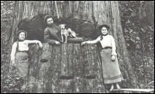
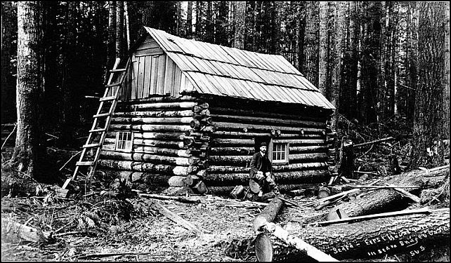
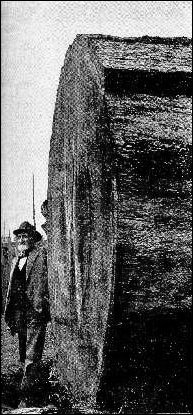
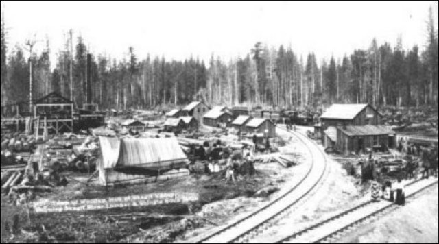
      Years ago, the late Howard Miller showed me this copy below of what was one of the earliest photos of the future-Sedro area. It was taken by Arthur Churchill Warner in 1894 and he wrote on the photo: "First house built in Sedro, Skaget Co., Wash." By good fortune, the University of Washington Special Collections has the original (number WAR0593). Unfortunately we have not been discovered where the cabin was or who it belonged to. It could have belonged to any of the four British bachelors who homesteaded the future acreage or Sedro — Batey, Dunlop, Hart and Woods. Or it could have been David Batey's first cabin that he built near the Skagit River before he built his 2-story house a mile north on the bench. Or it could have been the cabin built by Lafayette Stevens at future Sterling, circa mid-1870s, or it could have been the one that Jesse Beriah Ball built near his mill at Sterling. Just like with the derivation of the name, Sterling, we may never know.
      We researched Warner and discovered that he had a photo studio, Warner & Randolph, at Room 71, the Hinckley Building, at the corner of 2nd and Columbia streets, Seattle. Like many others, he came out to Washington Territory with the Northern Pacific Railroad, in 1886. Two years later, 1888, naturalist John Muir hired Warner to join and photograph a Mt. Rainier climbing expedition party that was guided by Philemon Beecher Van Trump, who was a member of the first successful ascent team in 1870. [See the Journal feature about that climb and William C. Ewing, founder of the Skagit News in 1884.] In 1890, Warner married Edith Randolph, the daughter of Captain Simon Peter Randolph, who supplied the capital for their business partnership. That resulted in a memorable series of Klondike Gold Rush photographs. The stress of living in the cold wilds of Alaska forced him to return to Seattle where he established a successful photography business that thrived until his death in 1943.Robert Monroe, curator of the UW Collection, learned that in 1925, Warner launched the Warner Projection Company, for which he created art deco projection slides to be used with cartoons and the lyrics of popular songs which might be projected on the theater screen so that audiences could join a pipe organist's renditions of popular songs. He and his wife also established a lecture business; he made the photographs and she tinted the glass slides by hand in the days before color photography.


      Sedro, on the north shore of the Skagit River in Washington Territory, was born in 1885 but it was weaned in 1889, the year when Washington became a state and many other cities burned to the ground. Like most Washington frontier villages, it was hacked and fashioned from cedar and fir trees right out of Paul Bunyan. The proportions were impossible for newcomers to believe until they stepped off a sternwheeler, saw a virtual sea of trees north of the Skagit River and smelled the pungent air up close.
      Mortimer Cook moved here in 1884 and started the village of Bug in 1885, but 1889 was when the railroad came and brought with it a primitive kind of civilization, a motley crew of speculators and roustabouts along with future merchants. Bug soon evolved into Sedro.
      Folks who lived here in 1889 worked from dawn to dusk in the woods or laying rails or plying the river, and Sunday was their only day off, if they were lucky. If they really got lucky, they hoisted their main squeeze up on top of a cedar stump and shook their bones to a Virginia Reel or a square dance on Saturday night. According to June Burn — a columnist for the Bellingham Herald in the early 1930s and one of a handful of my favorite Northwest writers, reported that survivors from that pioneer era told her a tall tale about those saloons on stilts:

      Stores and warehouses and docks lined the riverbank itself. Across the road from the waterfront the saloons and joints were built on stilts, or anyhow, high off the ground. The sidewalk ran along in front of this line of buildings, also on stilts. When a man had drunk so much he could drink no more, they pushed him out of the door and he generally rolled off the sidewalk and dropped the seven or eight feet into the mud below. Mr. [Charles Bingham, the banker] says he has come down many a sunny Monday morning to find the road lined with drunken loggers and railroaders. When the sun would come out and completely thaw them out they would get up, stumble around a little and then make off into the woods to their work. [1]
      When June came to the Skagit to research her columns in the early 1930s, she knew that the tales she heard were often as tall as the trees that once stretched off in all directions, but her intuition told her that the kernel of the folklore was real and true. The tales she recorded have survived longer than the documented history, which every schoolboy and girl knows can be a crashing bore. Actually the two surviving photos from that period show that the main street was about 100 yards from the waterfront and the buildings were not perched on stilts, but the streets were certainly muddy six to eight months out of the year. No newspapers survive that described the wee village clustered around the general store that Mortimer Cook opened right on the riverbank in 1885.
      The first newspaper in town was the Sedro Press, founded by South Dakota native George Hopp in April 1890. We are unsure how long that paper lasted. The only reference to an existing copy was made in 1953 by Ethel (Van Fleet) Harris, a daughter of Skiyou pioneers. The Skagit County Times began publishing in January 1891 in Sedro and the Skagit County Courier launched a decade later in Woolley. Those newspapers merged under Frank Evans in May 1920. Almost all records of the town from 1885-1898 disappeared long ago, except for the diary of Mortimer's daughter Nina and a precious handful of photos that were saved by her granddaughter, Barbara Budlong Taggart, and by various collectors. The vices that Burn heard about were certainly not overstated. Dancing women occasionally entertained in the rugged gyp joints, but hard-core drinking and the antics that John Barleycorn inspired were rampant and composed the most common floorshow. [2]


(old Sedro 1889-90)
      This very rare photo of old Sedro by the river is from a copy of the Fairhaven Gazette, a magazine that was published in 1890 to promote a paper railroad route that Nelson Bennett and other promoters of the town of Fairhaven on Bellingham bay planned. They projected two branches, one that would connect with Seattle to the south and New Westminster, B.C. to the north, and another that would cross the Cascade Pass to connect with a transcontinental line, either Northern Pacific or the Great Northern. The photographer stood by Mortimer Cook's general store and looked north. The depot is on the right and the main (only) street in town stretches perpendicular in the center.
      This view is intriguing because we see two things that we do not see in the other photo. This appears to be taken later than the other one because there is a dark building in the center that appears to have been erected very recently, along with a new two-story building behind it with a white upper story. The other fascinating landmark is what appears to be the steeple of a church, which June Burn talks about in a 1930 "Puget Soundings" column in the Bellingham Herald. Perhaps this is the original Presbyterian church building that Rev. Baldwin finagled from banker Charles Bingham. We know that the photo was taken after the summer of 1889 because the depot was not finished until then. Although the photo is from yellowed old pages and is not very clear, you can see that stumps still dot the landscape in the foreground and a dense forest still rings the small village. You can read Ms. Burn's column (which also has the Baldwin story) at this site and you can see the other photo on the Sedro Photos, Page One.


Fame was fleeting
      Skagit pioneers back then assumed that rain was their destiny and they celebrated the infrequent arrival of the sun. To make do on misty days they invented sunbeams in their minds. Charles Easton, founder of the fine bookstore in Mount Vernon, put it best in a 1969 Puget Soundings magazine article: "Pioneers came knowing full well the problems they would face. They accepted accidents, sickness and death philosophically. They were convinced that hard, backbreaking work would in time lead to an easier, better life." If a family included even a moderately good hunter or fisher, they would not go hungry on this fruitful land.
      The river did not spawn many famous people, but it sure attracted some great ones. History writers in Skagit County have long given short shrift to the early Sedro-Woolley events, usually looking down their nose as they dipped their quill into an inkwell or tapped away on their Underwood. For a short period from 1888-1891, however, Sedro was one of the most famous towns on the frontier. Financiers from all over the country placed bets on the town's future by buying lots either in old Sedro on the Skagit or new Sedro, which was located on high ground, a bench above the ancestral north shore of the river. Those speculators who knew all the tricks of the trade and were adept at sizing up their customers applied the "buy low, sell high" maxim as an art, often buying a corner lot at a bargain price in the morning from someone who needed quick cash to get out of town, and then selling it for a handsome profit by cocktail time. Like most fame, however, that was fleeting. When the railroad did not connect with the transcontinental lines, old Sedro by the river took a back seat while new Sedro, a half mile north on the bench briefly prospered. Then, when the nationwide Depression shut down the economy here and everywhere, starting in 1892-93, new Sedro faded, too, in favor of Woolley, the new company town of Philip A. Woolley, another half mile north.

      Many west-county residents who compiled early history for the first series of books from the historical society seemed to assume that we upriver people are all descendants of hillbillies after a few generations of intermarriage. Ten years ago the Seattle e e e Times even printed an application for prospective residents that had been passed around as a joke here for some time, but was very insulting in print. Yet we laughed along with everyone else. That is how the pioneers would have reacted. Bill Stendal, Sedro-Woolley mayor at the time and himself the son and grandson of true pioneers, turned the tables on the writer, Jean Godden, and rolled out the welcome mat for her. I remember Jean well from when we were in a writers luncheon group together. She took the comeuppance in her customary way, taking the time to look underneath the surface of the application that someone passed on to her and then she laughed along with us.

(Cook Store)
      Mortimer Cook's general store and post office in old Sedro, ca. 1888, Mortimer 5th from left. And his clerk, and future druggist, Albert E. Holland, 3rd from the right, in front of the doors. The photographer stood on Cook's wharf for sternwheelers. His home is upslope to the left, where the Rotary rock theater stands today at Riverfront Park. His daughter Nina is riding her horse.

Upriver pioneers shared a historical treasure
      The truth is that upriver towns share a historical treasure. Our common history is not any more real than that of the western part of the county, but it has a different flavor and a different sense of place, as historians often put it, because the upriver pioneers could not just paddle up the Skagit to Valhalla. Between the forks of the river and the future towns of Mount Vernon and Avon, on a bend of the river, a log jam resisted early efforts to dislodge it and the early upriver explorers had to portage around it, carrying everything on their backs for two or three miles. That was just the beginning of the challenge, followed by crags of trees just under the surface of the river that angled up, facing the current, like needles on a compass on a tirade, waiting to spear the soft underbelly of canoes or sternwheelers.
      James Cochrane and Joseph Wilson and other loggers and volunteers finally chopped a clearing through the upper logjam that was big enough for a sternwheeler to pass through. Only the most confident and experienced captains braved the riffles and eddies on the next 50 miles of the river, which was coiled like a snake up to Marblemount and Goodell's Landing. One legend recounts one of the most famous captains who left Seattle with a keg of whiskey in the hold. Wherever the steamboat was when the keg was drunk down to half-full, that was where he turned around, regardless of how much the passengers or hotel owners grumbled and sputtered. A few years after the logjams were cleared, Wilson moved to the Skiyou area and the early school district there was named for him, and Cochrane moved to Hamilton.
      George Washington did not sleep here, but Mortimer Cook did. There was no high noon, but J. J. Donovan did race through a blizzard to deliver a choo-choo train for a Christmas-eve present to Sedro in 1889. One-eyed James J. Hill of Great Northern fame met Jesus Christ here, and Norman Kelley and Duke Frederick George of Bavaria (and later of Duke's Hill) drank champagne and scotch respectively until they croaked. Art Seidell erected a building downtown in 1905, 40 years after he was a member of the squad that aided in the capture of Jefferson Davis near Macon, Georgia. A few future gazillionaires left a mark on the area, including Hill, who became an empire builder with his railroad; Charles X. Larrabee, who developed the mines at Cokedale, and Henry J. Kaiser, who provided ballast for the Puget Sound & Baker River railroad in 1905 and went on to build some of America's greatest dams and is remembered as one of the most famous U.S. industrialists in the first half of the Twentieth Century.

(Old man with log)
This Sedro old-timer posed at the butt end of a huge log in a photo published in the 1902 Sebring's Illustrated magazine, of Mount Vernon.

      From the beginning of the white-man era, this area has attracted many men and women who were just trying to get away from something back home. Some were either reckless or bewildered, but most of the pioneers shared a trait that was most important to the frontier. They possessed a skill or spirit that could be woven into the community at large. If they did not fit in, they just moved on to another town or deeper into the wilderness. In today's parlance, they were risk-takers. Very few people who were fat and happy in the civilized Eastern cities braved the challenges of trekking through the wilderness here, except for the speculators during the boom days, and those few left soon after fattening their purse or emptying it.

Settlers often followed the gold rushes but coal was king for Sedro
      The settlement of the west coast of America and Canada after the 1840s often followed major gold rushes, the first in 1849 at Sutter's mill in California, then in 1858 on the Fraser River in British Columbia, and finally in 1897-98 in Alaska, with a few minor rushes here and there between. Many of our pioneers moved to California first or traveled through that state before they came here. The original transcontinental railroad terminated in San Francisco in 1869 and schooners and steamboats carried them from there to their destination. Gold did not prove to be the mineral that kept newcomers here, however. Instead it was coal. That was why Montana mining magnate Charles X. Larrabee invested so heavily in the Fairhaven & Southern Railway (F&S) later in the 1880s to transport coal from the Sedro area to Bellingham Bay.
      Sedro was born 23 miles up the Skagit River and 63 miles north of Seattle because gold and coal miners and trappers told people back home about gigantic Douglas fir, Western hemlock and Western red cedar trees, which they claimed were as big around as bedrooms. In fact, some of the cedar stumps really were used as bedrooms. Cedar trees thrived wherever water stood for long periods; firs and cottonwood sank their roots on riverbank. The glacier-fed Skagit River meandered all over the valley for thousands of years, so loggers found monster trees in dense stands for miles north and south of the ancient riverbed that flowed nearly parallel to latitude 48 degrees, 30 minutes north. [3]
      A Bellingham Herald article in 1906 [4] described one fir in Sedro that was 54 feet in circumference and 328 feet high, although most of those ancient trees soared a mere 200-225 feet. Imagine for a moment the day the first hearty tree climber shinnied up a fir or cedar. At the top of one, he saw a green lawn of treetops with a handful reaching up more than 300 feet towards the sky, longer than a football field. Although gold petered out for miners by the mid-1880s, as did the trappers' market for beaver pelts years before, trees seemed inexhaustible. Spotted owls had plenty of room to nest back then. Art Robinson, an old Tarheel (North Carolina) logger and cousin of the famous Pinky Robinson from the Oliver Hammer Clothes Shop, took my family out to a first-growth forest near Baker Lake back in the early '50s and showed us some of the giant trees that predated the Protestant Reformation of the 16th century. Describing the sensation he felt when one of the firs crashed to the forest floor, he asked me to imagine my school bus dropping from the top of the tree. "It's like one of them San Francisco earthquakes every time," he drawled.


(Wyman Kirby with log)
      Sedro-Woolley Mayor Wyman Kirby, who was also a principal in the Skagit Mill at Lyman, stands at the butt end of a gigantic fir tree logged somewhere in the upper Skagit River region. Diameter 111 inches; circumference 30 feet; age by counting rings, nearly 700 years. Photo courtesy of the late Wyman Hammer, who was named for Kirby and who was one of the original benefactors of the Journal.

The last ice age formed the Skagit
(Log Jams)
This map drawn by 1873 surveyors shows the two logjams that choked the Skagit River at and below the future site of Mount Vernon. The city formed to the right (east) of the jams. Until a big enough hole was chopped through in 1878-79, those traveling upriver had to portage around the jams on a route at the left. Map courtesy of Larry Kunzler.

      The Skagit River rises about a hundred miles northeast of here in British Columbia, Canada. From there it turns southeast, then south through the North Cascades mountain range past Mount Hozomeen and Desolation Peak and finally on a predominantly western and southwestern course down the Skagit Valley. Geologists explain that, during the most recent Ice Age about 10-15,000 years ago, a massive continental ice sheet delimited the Skagit. One lobe progressed south from the Fraser River valley and another grew east from what is now Puget Sound. In between, the Skagit resulted largely from stream erosion between these two lobes as they melted.
      The Skagit carries the largest volume of water of any river between the Fraser in southern and central British Columbia and the Columbia, which forms the border between parts of Washinother large river (named for the Nooksack tribe) empties into the sound. About 60 years later, Henry Roeder chose that bay as the site for his sawmill and the village of Whatcom, which is now part of the town of Bellingham.
      Vancouver named the dominant mountain east of Bellingham, Mount Baker, for another ship's officer, Lieutenant Joseph Baker. Newcomers have used its symmetrical snowy peaks for navigation the last 150 years. Indians told Vancouver's crew about occasional fiery volcanic eruptions on the mountain. Later that same year, a Spanish explorer's ship ran aground in Bellingham Bay and the crew witnessed an eruption on Mount Baker. We heard second-hand that the sight alarmed the captain so much that he sailed the ship away as soon as possible. In 1880, Indians told white Sedro settlers Joseph Hart and Harry Devin about volcanic lava that whooshed south from Mount Baker down the Baker River and pushed logs, boulders and soil into the Skagit River. The debris washed downstream to the present site of Mount Vernon, forming two massive logjams that became a major impediment to exploration of the Skagit. [5]
      After conversations ten years ago with Larry Kunzler, a Skagit County flood-control expert, we wondered if a Mount Baker eruption, possibly in 1792, could have washed debris down the Baker and the Skagit and then formed the base for the logjams that limited exploration of the Skagit until the 1880s. We know from first-hand accounts that firs were growing out of these jams of timber to a height of 90 feet and firs grow about a foot per year. We were rewarded in 2001 when volcanologist and former Whatcom County resident Lee Siebert answered our email inquiry and led us to the fine Stephen Harris book, Fire Mountains of the West, published in 1988. Harris wrote about a log of a Spanish expedition that reconnoitered Bellingham Bay in June 1792. The vessels Sutil and Mexicana noted "the ominous rumbling and flashes of fire to the east that continued day and night, signs of a volcanic eruption." Such large-scale eruptions and subsequent mudflows have repeated once or twice a century. Siebert noted that the last super eruption of Mt. Baker occurred about 6,600 years ago. This confirmation of our hypothesis about the formation of the logjam was one of the sweetest moments in our first ten years of research for this project.
      The logjams blocked all but the heartiest pioneers from exploring upriver in the 1850s through '70s. The Skagit River channel formed an "S" above and below future Mount Vernon that was about two miles long. The northern bend formed where the town of Avon was soon platted, and the southern bend was located where Edgewater Park now stands in west Mount Vernon. The lower logjam was at least a century old, a conglomeration of silt, vegetation and driftwood about a half-mile long. The upper jam began a half-mile north of the lower one and was about a mile long. Over several decades, sediment lodged so thick on both jams that each sprouted growth of brush and large trees above and below the waterline. Very early Skagit settlers such as Otto Klement recalled the sounds that the river current made while ripping through the branches underneath and the moans and groans as logs rubbed back and forth against each other while trapped in the thicket.


Early exploration of the river
      Few immigrants were hardy enough to attempt settlement upriver from the logjams. A small group of argonauts explored the gravel bars of the upper Skagit in 1858 while waiting to join the gold rush to the Fraser River in Canada, but the log jams and difficulties in navigation discouraged them and they did not find the creeks where placer gold would be found in 1880. Northern Pacific railroad land engineer D.C. Linsley surveyed the area in 1870-71 for a proposed transcontinental railroad over the Cascade Pass and took with him a young assistant named Frank Wilkeson.
      Frank was a grandson of the man who was considered one of the fathers of the Erie Canal, and he was the son of the board secretary of the Northern Pacific railroad, both of whom were named Samuel Wilkeson. Frank was so bitten by the Skagit River bug that he returned here 15 years later and became a boomer in Sedro and Hamilton and lived in Fairhaven when he was elected as a state legislator. Over the next 15 years or so, he wrote dozens of columns for the New York Sun and Times that extolled the pioneer spirit of the Northwest and occasionally exposed the follies and foibles of the speculators.
      Within a year after the Linsley/Wilkeson expedition, New Yorker A.R. Williamson moved north from Ezra Meeker's Puyallup hop ranch and planted extensive hop farms near the site of future Lyman. Then in 1873 Otto Klement paddled across Puget Sound and up the Skagit River, settling at various points until he sank down roots in Lyman in 1882-84. [6]
      Amasa "Peg-Leg" Everett and Lafayette Stevens searched for coal in the mountains across the river from future Hamilton, starting in 1873, and found coal ore there next year; they persevered even though Everett lost his leg in the process. [7] In the mid-1870s a handful of rugged pioneers braved the wilderness of the upper Skagit even after being forced to portage around the downriver logjams.
      In 1877-78, Birdsey Minkler carved out a homesite and started the first water-powered sawmill on the south shore of the Skagit at what was soon named Birdsview. August Kemmerich and John Grandy joined Minkler after logging with him on the Olympic Peninsula. William Hamilton brought his family from Kentucky and started his namesake village on the north shore of the Skagit across from where Everett found coal.
      Kemmerich's fellow German immigrant Karl (Charles) von Pressentin [8] and his brother carved out other sections near Minkler's Birdsview village, starting in May 1877. George Savage moved his family upriver in the late 1870s and bought Minkler's mill, and they were joined there three years later by Savage's brother-in-law Lewis A. Boyd. What a hearty lot of pioneers, yet their stories were often only superficially recorded. Only after the beginning of a short-lived gold rush on Ruby Creek were the log jams finally opened wide enough for passage by sternwheeler, and then a flood of argonauts fought against the Skagit's current to seek the precious yellow metal.


The settlers confront the Indians
      Indian tribes had free reign in the Skagit River valley and around Puget Sound for centuries, but settlers began arriving in the Oregon and Washington territories in progressively greater numbers in the mid-1840s through mid-1850s, leading to battles and uprisings from the Whitman mission near Walla Walls to the Yakima region to south Puget sound. Future Skagit County was still relatively unexplored at that time. Most early settlers in the far Northwest corner of Washington territory were congregated on Whidbey and San Juan islands and at Whatcom, Henry Roeder's new town on Bellingham bay. An impressive blockhouse was built there for defense, which rivaled the one built in Seattle. Washington separated in 1853 as a distinct territory from Oregon, with the boundary formed by the Columbia River most of way. Gen. Isaac I. Stevens was sent out from New York to calm the Indian situation and he was appointed the first governor of the territory.
      Chiefs of many Puget sound tribes saw the inevitable greater numbers of white settlers and most signed the Point Elliott treaty, which was negotiated on January 22, 1855, and ratified by April 11, 1859. By doing so, they ceded their lands and agreed to move to reservations. Among the holdouts were the bands that called the upper Skagit and Sauk rivers home and they struck back often when surveyors finally showed up starting in the late 1870s. Skirmishes with the settlers, especially with Amasa Peg-Leg Everett on the Baker River, flared up in the early 1880s. The Indians there were less impressed by the white man's tools of civilization than some of their brethren downriver and they were bitter about the other tribes ceding ancestral land. Chief Martin Jacob Sampson of the Swinomish tribe, who was born at the downriver fork at Skagit City in 1888, described the tribes in an excellent book, Indians of Skagit County. We condense part of his story:

      They lived a life in harmony with nature, using the gifts of the sea and the earth without exhausting or destroying them. Each tribe or band had its permanent villages and its accustomed camping sites for fishing, gathering roots or berries, or for hunting. There was no tradition of agriculture since none was required. Food grew plentiful and wild and needed only to be gathered and eaten fresh or preserved by drying.
      There was no concept of ownership of any particular piece of land by any individual, although tribes habitually used certain definite areas; their territories were respected by other tribes. As in other areas of the western American frontier, land ownership was to be the major disagreement between tribes and the white settlers. There were skirmishes here, to be sure, but both native and newcomer finally found a common ground. Through the years, many Indians died from the white man's diseases, and the fish stocks that seemed to be inexhaustible eventually shrank to the point that fishing seasons are severely limited today. [9]

      White settlers and Indians amazed each other. Indians often waded through the swift river current to avoid walking through forests that might be inhabited by unknown spirits. Whites often wondered why Indians avoided looking into newcomers' eyes. But some Indians feared that white-eyes might be a magician who was intent on stealing their spirit. That is, of course, what actually happened. When the settlers learned of their host's fears, they ascribed them to superstition. Indians assumed the same when they saw the newcomers genuflect to the body of a man crucified on a cross.
      Indian children bathed in the icy-cold river so many times that pain from the cold disappeared, replaced by courage. Indians of all ages wondered why the newcomers smelled so bad. Indians bathed in streams and the river almost daily while whites sometimes went a month or more without a bath. Noble white men deplored how the Indian women subjugated themselves to their mates. Noble Indians noted that they rarely struck their women physically, as the whites were prone to do. The immune systems of the natives eventually betrayed them as they died in droves after infection from the white man diseases. In the 1880s, smallpox finally dealt the blow from which Indians could not recover. Indians died in such large numbers that their tribes could not bury them fast enough. Burial crews from the new Skagit County government moved in to bury the Indian dead and to burn the villages most affected.


British bachelors settled future-Sedro before Mortimer Cook arrived
(Batey and Hart)
David Batey and Joseph Hart, circa 1890s

      While teams of volunteers cleared the logjams near Mount Vernon enough for upriver navigation by 1878, two bachelors from England settled at the future site of Sedro-Woolley. Sometime in May that year, David Batey and Joseph Hart took a steamboat from San Francisco to Seattle, where they boarded a sternwheeler to LaConner. Hart had already settled at the White River Valley in eastern King County for a short while and heard about the vast forests in the Skagit Valley and the riverfront land still open to homesteading. They bought an old salt chuck (sea) canoe in LaConner and paddled down the sound to the north fork of the Skagit River. From there they poled upstream to the two logjams where settlers had hacked a narrow channel. But the current was so swift that the newcomers were forced to lug their belongings anyway on a blazed trail around the obstructions. They then returned to skid their canoe around the same route. Indians made good money for their skills at portaging. The entire process took as long as three days, depending on the weather.
      After a short visit with Rev. B.N.L. Davis (who tended his flock from the Sound to the Cascades) at Riverside, where the two major bridges now cross the river, Batey and Hart poled upriver after the minister advised them how to navigate and avoid the nasty snags in the fast-flowing current. Although they poled upriver as far as future Lyman and Hamilton, they suspected that the gooseneck of level valley land there would be far too narrow for land travel and railroad access, should a rail line be envisioned through the Cascades in the future. Instead, they chose to settle at a natural landing located just west of future Sedro that we now call Hart's Island, a horseshoe-shaped sandbar where Indians camped for centuries. [10]
      In those early months they were alone and many times that year they were destitute. The outside world was still reeling from the 1873 financial panic, but the bachelors were living on their own Walden Pond, independent from urban centers. The only sounds they heard were those of nature, the crashing river, chattering birds, wind blowing through the leaves, and the screams of wild animals, including bears, cougars and mountain lions. Skiyou settler Eliza Van Fleet later wrote that the men learned to subsist like the Skagit Indians who camped on the island and taught the white newcomers how to fish for salmon and steelhead. The bachelor settlers relished the Indians' bullhead (fish) stews and they learned to make sauces from the wild crabapples and currants they found growing near the riverbank. Indians taught them to cut out the acorn gland in a bear's knees that spoiled the taste of meat. Initially the newcomers did not even have nails for building a cabin. They chopped cedar trees and split lumber to build a simple lean-to shack out of poles, rough boards and blankets. When the wind blew they had to run out and stand on both sides of their lean-to and hold the pieces together by hand until the wind subsided.


Settlers finally get steamboat service
      One day they left their shack on a hunting trip and came back to find it burned to the ground along with most of their provisions. During the following weeks, Hart became exhausted and malnourished. Batey took their only gun (the stock was burned off in the fire) and he used dried peas for shot to bag a duck and some pheasants for their meager larder. They decided to row to the primitive Ball's Camp store, a mile to the west, for provisions, but found only crackers on hand. Next they rowed a half-day down to Harrison and Clothier's trading post in Mount Vernon, but there were no staples there either. Their only choice was to walk down to Skagit City on the south fork of the Skagit, where they boarded a steamboat to Seattle. There they purchased a large supply of provisions and arranged to ship the goods aboard a sternwheeler, the Gem, which was being outfitted for service on the Skagit.

(Glide Sternwheeler)
      Nina Cook wrote in her diary that she and her mother and sister Fairie arrived at her father's wharf in June 1885 in the sternwheeler Glide, which was photographed above, circa 1905, towards the end of its service on Puget Sound and the Skagit River.

      They returned home by the same route with enough goods to get by and sweated out the next two months until the Gem made its inaugural trip upriver to Ball's Camp. When the Gem did arrive, a deckhand told them how the steamboat barely made it though the logjams. The channels through the jams had been widened, but the current of water was still dangerously swift. To counter it, a crewmember had to jump onto the jam, catch a rope thrown from the steamboat and fasten it to an upended log. A deckhand then wound up a windlass that pulled the boat on upstream. Two other bachelors from England and Ireland joined them in the fall of 1878: William Dunlop and William Woods. A freshet of March 17, 1879 washed out the remainder of the jams so boats could navigate freely from then on.
      In January 1878, Jesse Beriah Ball [11] built a sawmill west of future Sedro on the north shore of the Skagit on timberland that was originally cruised by Winfield Scott Jameson, whom Ball knew from California in the 1860s. Ball's future town of Sterling became the first major trading center east of Mount Vernon and the last navigable point for sternwheelers on the Skagit during the summer low-water months. For the next six years, Ball, the four British bachelors, German blacksmith Henry Holtcamp and German brothers John and Fred Kiens and two handfuls of other hearty settlers began slowly cutting the abundant timber along the shoreline and moving up the slope, felling dense stands of cedar, Douglas fir and hemlock along the way.
      Everyone along the river was dependent on it for transportation most of the time. The dense forest, the deadfalls and the muddy soil many months of the year conspired to discourage travel overland so freight, passengers and products from settlers' farms were all carried on either Indian canoes hewed out of cedar or small sternwheeler steamboats. The sternwheeler was the preferred freight-boat on the river because it had a very shallow draft and could shove up onto the low sandy banks, and shove off in reverse.
      A noted steamboat captain also homesteaded here in the late 1870s. Daniel Benson, a Civil War veteran from Michigan, came to Seattle with his father Stephen in 1871 and he later homesteaded a quarter mile up Hansen [then Benson] creek in the Skiyou district, adjacent to the Van Fleet homestead. By 1880, he built a log house and planted an orchard and his wife soon joined him in August 1880, to the joy of Eliza Van Fleet, who arrived with her husband, Emmett, three months earlier.
      Daniel was the master and captain of several upriver and Puget sound steamers, including the Chehalis, City of Quincy, George E. Starr, Edith Washington, Josephine, (partially owned by Jesse Ball from Sterling), and the Eliza Anderson [12]. As more settlers and loggers moved to the area, those with foresight realized that a railroad would be needed to transport the logs from trees rising up to 300 feet and more. That small group of brave men prepared the upper Skagit for the railroad and for settlement, which would begin in the late 1880s as rail lines were constructed from three directions.


Mortimer Cook founds Sedro
      In 1884 a former mayor of Santa Barbara, California, bought acreage on the north shore of the Skagit and timber rights on acreage that extended from Hart and Batey's original site up and over the low foothills, including what would soon be named Duke's Hill. Mortimer Cook may have visited this area during the short-lived 1858 gold rush on the Fraser River in British Columbia. He and Whatcom founder Henry Roeder formed pack teams to carry supplies overland to Fort Hope, located where the Fraser turns west in lower B.C.
      Three years later, Cook founded a town on the nearby Thompson River that he called Cook's Ferry. When he returned to northwest Washington and chose his spot on the north shore of the Skagit River in 1884 he laid out plans for a mill which he built in 1885. In his inimical way, he first called the town, Bug, after the bat-sized mosquitoes that buzzed above the swamps and peat bogs north and south of the river. But his wife objected to the name and the handful of ladies who had settled here with their husbands inveigled him to change it, so he chose Sedro, a variation of the Spanish word for cedar, cedra. [13]
      Cook's operation was the first shingle mill of its kind in the territory, incorporating a drying kiln that reduced the weight of the wet cedar shingles so they could be shipped by rail to markets in California and the East, where his brother was an agent based in their home state of Ohio. Just before Cook arrived, settlers south of Chuckanut Mountain successfully chipped off Skagit County from the larger Whatcom County in December 1883. Some people have assumed that because the town was originally named Bug, this was the inspiration for the slang name of Northern State Hospital — the Bughouse. There was no such connection. Bughouse was already coined as a term for an asylum years before the Webster's Dictionary listed it in the 1913 edition. We have used the two words, Bug and Bughouse, because they are sort of bookend terms for the first 50 years of settlement on the river.
      The genesis for the boomtown of Sedro, however, was due to the discovery in the late 1870s by pioneer Lafayette Stevens of coal veins that extended southeast from similar deposits around the Washington-British Columbia border]. [14] The most pronounced vein that was easiest to mine lay about five miles northeast of the mill and general store that Cook built on the river. V.A. Marshall invested in what Stevens called the Crystal Mines and the logging camps provided work parts of the year for German immigrants such as Henry Holtcamp, Fred and John Kiens [15] and Henry Harms Dreyer, who homesteaded a ring of quarter sections west and north of future Woolley. Financiers started paying attention to the area by the late 1870s, not only for the timber but also especially for coal.


(Cokedale mine)
      We have never been able to find the provenance of this photo but it of one of the shafts of the Cokedale mines. The coal seam was discovered in 1878 by Lafayette Stevens, a miner who moved to LaConner from Nevada in 1873. The mine was excavated on a larger scale by railroad promoter Nelson Bennett ten years later and was the magnet for the first railroad, the Fairhaven & Southern line, rather than timber being the prime export product as most people assume. The F&S line connected both old Sedro and the mine — six miles to the northeast, with Fairhaven, 26 miles northwest, where bunkers on Bellingham bay were filled with the coal before it was distributed to San Francisco and other cities. The late Mort Bean said that this was just one of the villages that his father, the legendary Harry Bean, recycled completely. There is nary a stick nor a stone left to show of it.

Nelson Bennett, Cokedale Mines and the F&S Railway
      In 1888 a railroad promoter named Nelson Bennett came to the area and bought Stevens's mineral rights and dreamed up a railroad to transport it to ships on the Puget Sound in Fairhaven (now south Bellingham). Bennett and his brother Sydney gained fame from their rapid railroad construction across the Rockies and they had just completed the mammoth Stampede Pass tunnel through the Cascades for the Northern Pacific. In just one year's time Nelson Bennett constructed the first standard gauge railroad north of Seattle, the Fairhaven & Southern Railway, which stretched diagonally northwest from the Cook's townsite on the river and the coal mines to Bellingham Bay. They could not accomplish their goal, however, without the additional capital that Charles X. Larrabee invested for both the coal mine and the railroad.
      The first train chugged into Cook's original townsite on Christmas Eve, 1889, just one day before the deadline. The only surviving track in 2007 from that line is a short diagonal stretch near the old Skagit Steel plant west of Metcalf Street, the same track you can see in the photo above. The F&S Grade Road is laid along the old railway roadbed; those tracks were ripped up from 1900-02. The tracks continued on a diagonal through the towns of Woolley, which rose in 1890, and both new and old Sedro, all the way to within 50 yards of Mortimer Cook's wharf.
      The old Skagit Paint building that stands south of Whidbey Island Bank has a triangular-shaped northern wall because it was built along the tracks. At a spot a block and a half east of Township Street the tracks turned south to the river. The present Railroad avenue was the eastern portion of the "wye" that proceeded northeast via what is now Railroad avenue to the Cokedale Mines, which evolved from the earlier Stevens discovery. The old Lyman, or Minkler, Highway now follows that old roadbed.
      The investment in the F&S line and the Seattle Lake Shore & Eastern line (SLS&E, which ran north-south, later the Northern Pacific) also attracted Eastern investment capital to clear and build the towns of old- and new-Sedro in 1889. Bennett and Larrabee really made the mine hum in 1891, but Great Northern magnate James J. Hill bought both the mines and the rail line and developed the town of Cokedale as well. Although old tales persist that there was a population there at it peak of 2,000, we have found no evidence of such. The various censuses account for just over 500.
      The mine, which produced coking coal rather than a heating source, operated at full speed until well after the turn of the century, but ran out of steam by 1920. Over the years, the mines were know by many names: Skagit Valley Mines, Crystal Mines (when the property was sold by Stevens to Bennett), Bennett Mines, Hill Mines, and Great Northern Mines. The Helmick road, named for the grocer who transported staples there in his wagon, was cut through the swamp to the area that was just east of what is now the Upper Skagit Indian Reservation and Northern State Hospital's old dairy farm.


      So far, we have never found photos of new Sedro, the town that Norman R. Kelley and logger Winfield Scott Jameson platted around the block where the high school stands today. We have only found a blurred photo of Jameson Avenue in an old newspaper. We especially hope that a reader will find such photos in their family collection. The top photo below is from an 1890 edition of Washington magazine, which has drawings that may have been of existing buildings or else buildings that were planned. The bottom illustration is from a drawing that used to hang in the Skagit Realty building on Metcalf Street. We also do not have any photos of old Woolley in the early 1890s and we also hope a reader will find some.
(New Sedro drawing)
      This was the architect's drawing for the Sedro Land Improvement Co. building in new Sedro, which we found in an 1890 issue of the Washington magazine in the University of Washington Allen Library Archives. We have no photos of new Sedro and we hope that readers will find some in their collections. On a hunch, we guess that the building was on the southeast corner of the Third Street block between Nelson and Bennett streets where the high school stands today. For old-timers, think of where the tennis courts used to stand for the high school, the present location of the main office. That was then called the Pioneer Block. From the buildings surrounding the one above, we conclude that there was a bustling community there in the early 1890s, but all had fallen to fire or had been razed by the time that the school was erected in 1911.

(Hotel Sedro)
      This was the architect's drawing for the Hotel Sedro, which stood on the west side of Third Street where the Carnegie Library was erected in 1915. The library was razed in 1964 and the present high school gymnasium replaced it. The hotel was the dream of two young men who grew up as neighbors in New York City, Norman R. Kelley and Junius B. Alexander. They built it in 1890 in anticipation of the large crowds that would depart at the Seattle Lake Shore & Eastern railroad depot, which stood just west of the present high school football field. Unfortunately, P.A. Woolley platted his town a half mile north at the same time and the Union Depot that was erected at the north end of his company town usurped the passenger business from the other depots in old and new Sedro. The hotel was already in receivership by the fall of 1890 and it soon became a relic. After the hotel fire of 1897, the building was largely vacant and it was razed at an unknown date. Since all the newspaper volumes of that era are long gone, we have no details about the hotel in the 1890s, nor do we have photos. We hope that readers will find material about it in their collections. The drawing is from the old Skagit Realty office.

New-Sedro briefly rises
      A Seattle syndicate led by the young sons of two New York financiers began laying out a new site of Sedro in September 1889. Norman R. Kelley was a draftsman for the Seattle Lake Shore & Eastern SLS&E], originally funded by Seattle entrepreneurs who wanted to compete with Tacoma to the south, which the NP chose as its terminus in 1873 to the shock and dismay of Seattle interests. Kelley brought with him Junius Brutus Alexander, an 1890 graduate of Harvard, and Albert G. Mosier, an engineer who had been educated in Iowa. Alexander's and Kelly's fathers were business associates in New York City.
      About 25 years later, Alexander the younger moved Sedro-Woolley up the list for Carnegie library sites due to his family connections. That fine old Carnegie Library opened across Third Street from the present high school (opened in 1911), which was also the site of Kelley's town, or what we call new Sedro, which was born in 1889. Kelly formed the second Sedro site by making a deal with Winfield Scott Jameson, who had been logging in the Skagit Valley and upriver since the late 1870s. He was the namesake of Jameson Avenue, which is the widest street in the merged towns because it was originally a stretch of the county highway, although a very muddy, unpaved
      Contrary to popular opinion, the original settlers of the Sedro-Woolley region were not from North Carolina. Actually there were just a handful of Tarheels in the beginning and most settled upriver from Sedro; the major migration from there occurred after 1912. Ten or more of the original Sedro settlers came from southeast Iowa, mainly from the small town of Marengo. Those included C.E. Bingham, who established his first bank in old-Sedro in July 1890. His wife urged her sisters and a cousin, of the Reno family from Marengo, to join her later in the decade and three of them married key Sedro-Woolley town fathers.
      Another state, however, provided the most early residents. At least 50 Sedro-area settlers came here in the 1890s from the town of Lincoln, Kansas. They followed Emerson Hammer, who moved to the Skagit valley in 1889 after marrying the daughter of George Green, Lincoln's founder in 1870. Hammer soon clerked for Mortimer Cook at Cook's store near Sterling, then opened a store in Burlington, and moved to Sedro-Woolley permanently when he joined his father-in-law in the Union Mercantile, Sedro-Woolley's first department store. Green also followed his son-in-law and backed several of the original mills in the area, along with stores in Burlington and Woolley. Most of the rest of the early pioneers came mainly from the Midwest area, centered on Wisconsin and Michigan; and many others immigrated via Canada from England and the Scandinavian countries.


P.A. Woolley builds a sawmill and his company town
      Old Sedro, by the river, and new Sedro, where the high school now stands, were soon eclipsed, however, after an eastern promoter named P.A. Woolley moved here from Elgin, Illinois, and purchased land a mile northwest from the twin Sedros in 1890. Woolley had the foresight to realize that three railroads would soon cross at that point, the two lines above and the Seattle & Northern. He also a very important friend, Gen. James Bard Metcalfe, who was the only attorney general for Washington Territory, and apparently knew where the rail lines were slated to cross: the north-south Seattle Lake Shore & Eastern line and the east-west Seattle & Northern line, both of which were criss-crossed by the F&S line, forming an iron triangle of tracks next to Woolley's Skagit River Lumber & Shingle Mill. Woolley started his namesake company town around the mill, which supplied railroad ties for two of the rail lines.

(Woolley Mill)
      In this Darius Kinsey photo, circa 1898, we believe we are looking northeast and that the train in the center is the Seattle Lake Shore & Eastern. Notice the cluster of buildings that would have been north of Northern avenue, if we have our bearings correct.

      Woolley's and Cook's wives were the "mothers" for each town and played a large role in civilizing the brawny loggers and railroad men and setting up institutions such as churches. Although there are persistent myths that Woolley and Cook were antagonists, we have no such evidence. The myth usually rests on the fact that the towns were platted on perpendicular axes, resulting in north-south streets that do not meet, but Albert G. Mosier platted both towns and he never told historians the reasons for the different platting. Alexander's mother was the namesake of St. Elizabeth's Hospital, the first Skagit County hospital, which stood at the southwest corner of Fidalgo and Township streets and also briefly served as the Episcopal church. The Catholics, Presbyterians and Methodists formed the rest of the early churches.
      The 1890s decade started with a roar as the two towns competed for business connected with the three railroad routes, the coalmines, the lumber mills and the farms that were sprouting up on the logged-off lands. Then the national financial panic of 1893 pulled the rug out from underneath the two towns. They did not fully recover until 1898-99 as a result of another gold rush, this time the bonanza of them all, in the Klondike region of Alaska. After eight years of competing with each other, the two towns merged in December 1898 and became Sedro-Woolley. By the turn of the century, the new merged town were roaring full speed, riding the back of a second boom economy. By that time the merged town of Sedro-Woolley dominated the commerce of the county and attracted both upwardly mobile, young middle-class entrepreneurs and settler families.
      With Hill's backing, the Cokedale Mines provided one of the most consistent payrolls of the area as 50 beehive coke ovens were built to process the coal that was highly valued in steel making. Steam "donkeys" dotted all the low foothills of the Cascades as logging moved up and away from the rivers at the turn of the century.. Logging was still backbreaking work and dependent on strong young men and teams of oxen that were used to drag the logs on skid roads down to the Skagit River. As more speed was needed to transport the logs over longer distances, teams of horses replaced the slower, plodding oxen. Then, starting in the late 1880s, steam donkeys powered long cables that dragged the logs from one point to another. At the river the logs were boomed together and pushed downriver by sternwheelers to log yards at Riverside in Mount Vernon. At one time there were 17 shingle mills within just a few-mile radius of Sedro-Woolley and hundreds of men worked 6 or 6 1/2 days a weeks, 12 hours a day.


Settler genealogy
      Men still outnumbered women in the area by a ratio of 2 or more to 1 as the century began. In the early days, when Caucasian women were scarce, loggers and farmers took Indian girls as wives. These young girls from the various Skagit Indian bands were called Klootchmen and were expected to literally keep the home fires burning on preemption claims and often worked as hard, if not harder, than their husbands. Early settlers were able to claim up to 160 acres of government land at a cost of $1.25 per acre in their own name, and another quarter section in their spouse's name. As women began braving the trip from back east or California, the klootchmen were often unceremoniously sent back to the reservation near LaConner, but some stayed on the family farms, becoming babysitters for the children of the new wives. You may notice that we do not mention many women in this overview. That is partially because the wives did not start arriving until 1880 and were not present in great numbers until the 1890s. A frontier wife worked as hard as her husband and the older girls in a family had their hands full, caring for younger children in families with five to ten members. Our Free Home Pages include an entire section on women who shaped the river communities, including more than 20 profiles and many photos
      Population surged in the new town of Sedro-Woolley in the first decade of the century, growing rapidly past 1,500. Telephones were installed in 1899, and lines originally strung out of the office of the Skagit County Times at the southeast corner of State and Third streets. Soon thereafter electric power was installed, beginning in 1902, and Wilfred Morgan's then added a water company to his power company, piping in water from springs in the hill near Day Creek through a wooden pipeline that was suspended over the river. A sewer system was dug underneath the main parts of town throughout the decade.
      The principal streets were originally planked so that horse teams could avoid being mired in the omnipresent mud. So was the original Skiyou or Hoehn road that ran east to the upriver communities and connected with Railroad Avenue and State Street. The road was named after pioneer Frank Hoehn, who moved here in 1889 after a wild childhood and adolescence during which he sometimes rode in Buffalo Bill's Wild West show. There was a surplus of wood because — to the horror of modern-day environmentalists, up to 90 percent of the original cedar forest was burned in slash piles after being cleared for the three townsites. Therefore, planked roads were cheap and practical. By the time of the great fire in the downtown of Woolley in 1911, both sidewalks and streets in the downtown area had been paved with either concrete or gravel. The entire site of Sedro-Woolley was clear-cut by 1914. All the trees here now have been planted since the turn of the century. Settlers such as North Carolina native Lunde Perry soon learned that almost any tree from any part of the world could be propagated here, so he quit the woods to become a Johnny Appleseed tree salesman while also selling cars for the Model-T Ford dealer, Len Livermore.
      In 1906, according to the book, Illustrated History of Skagit & Snohomish Counties, Sedro-Woolley was a bustling town with many of the amenities that were available in Seattle, including an opera house, electric lighting, a telephone system and a sewer line for sanitation. Over the next six years real wealth doubled and tripled as two key developments occurred. First, a second Washington state mental hospital was built 3 miles northeast of town, opening in 1912 after two years of land clearing and construction. A vast 1,200 acre campus was laid out and designed to be self sustaining, with its own power plant, dairy, and greenhouse, and crews of inmates who performed almost all the necessary jobs under close supervision. The hospital, eventually known as Northern State Hospital, remained a major payroll for the next 60 years until it finally closed in 1976. Alexander, Charles J. Wicker Sr. and Harry L. Devin were the primary real estate developers and Wicker profited greatly from the placement of Northern State Hospital. Druggist Albert E. Holland, who shared a building with banker Bingham, became wealthy investing in timberland as a financial backer for Wicker and Devin.
      Second, in 1912, an eastern development company called Stone & Webster from Massachusetts extended an interurban railway to Sedro-Woolley from Bellingham via Chuckanut mountain and Burlington, tying the town to the outside world and connecting to a system from Seattle and Bellingham. That also opened up the river to hydroelectric development by the same company and over the next few decades they would promote dams that would power much of the western part of Washington state.
      The area continued to boom through World War I and attracted an entirely new population of loggers — the majority coming from North Carolina, along with farmers and young businessmen who built the nucleus of the town that we know today. Old-timers used to say that the major local payrolls here were like a three-legged stool: Northern State Hospital, the Interurban and logging camps and mills. Other people replaced a leg or two over the years with the Cokedale mines, Skagit Steel & Iron Works, agriculture and railroads, but you get the picture.
      Although some people used the term, Bughouse, as a way to make fun of Sedro-Woolley and Northern State Hospital, people who lived here usually used it in an affectionate vein. Although some people were afraid of the hospital and its inmates, the people who worked there and many who lived nearby realized that the patients had a mental disease or just could not function well in society. Many of the psychiatrists who staffed the hospital were leaders in the movement to understand mental disease instead of just locking people away, and patients were soon given the right to work on crews outdoors, maintaining the huge 1,200-acre campus. After retiring from the U.S. Navy after World War II, my father, Vic, moved our family here and had another career leading those crews. By the 1940s, the hospital management encouraged visitors to the hospital and events were planned where patients and outsiders met and engaged in recreational pursuits. At one time, the Loggerodeo parade was extended to the hospital ground. The hospital is not only a bookend for our history of Sedro-Woolley that begins with the village of Bug, but it was the thread that tied together the local economy and industry from 1909 until it sadly closed in 1976.


Footnotes and websites for above story:
1. See the Journal website for Frank Wilkeson's hilarious 1890 New York Times column about how the Sedro drunks and hobos caroused. Return
2. June Burn, "Puget Soundings" (a newspaper column), Bellingham Herald (unknown date, 1931). Return
3. Larry Kunzler, Sedro Woolley author of Skagit River Valley, the Disaster Waiting to Happen, Oct. 2, 1995 interview. Return
4. "Sedro-Woolley, Key to Upper Skagit," Bellingham Herald column, Sept. 30, 1906. Return
5. Chris Jonientz-Trisler, volcano monitor at University of Washington seismology lab, quoted in the Skagit Valley Herald newspaper, June 19, 1991. Return
6. Otto Klement, "Early Recollections," part of an unpublished manuscript, Early Historical Incidents of Skagit County, which Ethyl Van Fleet Harris edited from conversations with Klement and letters he wrote in the 1920s and '30s. Parts were published as columns in the Mount Vernon Daily Herald. The manuscript is in the Northwest Collect, University of Washington, Suzzallo Allen Library, dated 1932. Return
7. See the Journal website for the Everett story. Return
8. See the Journal portal website for the von Pressentin family with links to 13 features. Return
9. Chief Martin J. Sampson, Indians of Skagit County, (Mount Vernon, WA: Skagit County Historical Society, 1972), page 11. Return
10. See the Journal website for the story of the Four British Bachelors. Return
11. See the Journal website for the Jesse Ball/Sterling story. Return
12. See the Journal website for the Benson family story, including Steamboat Dan Benson of Skiyou (original namesake for Hansen Creek). Return
13. This section about the town name was partially derived from:
      Esther McKibbin, unpublished manuscript, Early Historical Incidents of Skagit County, Northwest Collection, University of Washington, Suzzallo Library, Allen Division: 1932.
      Eliza Van Fleet, Earliest History of Sedro-Woolley, handwritten unpublished manuscript, Feb. 23, 1917, Bourasaw collection via Virgil and Rose Van Fleet 1994.
      See the Journal website for the hilarious story of why Mortimer Cook originally chose the name Bug and how that was changed to Sedro [Link repaired]. And we have just posted the actual newspaper story that pegs the month in 1885 when Bug became Sedro.

Mea Culpa: Confession is good for the soul
Mea culpa, cedro
      Even our overworked award-winning team of Journal fact checkers and copy editors blow it big time now and then. This time, however, their mistakes are both repeated and egregious. While they are behind the woodshed being flogged, we apologize and admit the errors. Over the years, we have variously written that the Spanish word for cedar was cedra or sedra. But, dear reader, once your humble editor actually consulted a dictionary, he discovered the Spanish word is instead, cedro. Therefore, Mortimer Cook simply changed the c to s. Return
14. See the Journal website for the Lafayette Stevens story.Return
15. See the Journal Kiens family website Return


Links, background reading and sources

Story posted on Aug. 26, 2000, last updated Dec. 25, 2010 — this was the original page of the entire website, beginning in August 2000
Please report any broken links so we can update them. Updated Oct. 2017


Getting lost trying to navigate or find stories on our site?
Read how to sort through our 800-plus stories.
Return to the new-domain home page
Links for portals to subjects and towns
Newest photo features
Search entire site
Looking for something special on our site? Enter name, town or subject, then press "Find" Search this site powered by FreeFind

    Did you find what you were seeking? We have helped many people find individual names or places, email if you have any difficulty.

    Tip: Put quotation marks around a specific name or item of two words or more, and then experiment with different combinations of the words without quote marks. We are currently researching some of the names most recently searched for — check the list here. Maybe you have searched for one of them?


(bullet) See this Journal Timeline website of local, state, national, international events for years of the pioneer period.
(bullet) Did you enjoy these stories and histories? The process continues as we compile and collaborate on research about Northwest history. Can you help? Remember; we welcome correction, criticism and additions to the record.
(bullet) Please report any broken links or files that do not open and we will send you the correct link. With more than 800 features, we depend on your report. Thank you.

If you would like to make a donation to contribute to the works of this website or any of the works of Skagit County Historical Society and Museum. We thank you up front. While in your PayPal account, consider specifying if you would like your donation restricted to a specific area of interest: General Funds, Skagit River Journal, Skagit City School, Facilities, Publication Committee, any upcoming Exhibit. Just add those instructions in the box provided by PayPal.

Please sign our guestbook so our readers will know where you found out about us, or share something you know about the Skagit River or your memories or those of your family. Share your reactions or suggestions or comment on our Journal. Thank you for taking time out of your busy day to visit our site.

Currently looking for a new guestbook!


View My Guestbook
Sign My Guestbook
Email us at: skagitriverjournal@gmail.com
(Click to send email)
Mail copies/documents to Street address: Skagit River Journal c/o Skagit County Historical Society, PO Box 818, 501 S.4th St., La Conner, WA. 98257