(Girl Undercut)

Skagit River Journal

of History & Folklore
Subscribers Edition, where 450 of 700 stories originate
The most in-depth, comprehensive site about the Skagit

Covers from British Columbia to Puget Sound. Counties covered: Skagit, Whatcom, Island, San Juan, Snohomish & BC. An evolving history dedicated to committing random acts of historical kindness
Noel V. Bourasaw, editor (bullet) 810 Central Ave., Sedro-Woolley, Washington, 98284
Home of the Tarheel Stomp (bullet) Mortimer Cook slept here & named the town Bug

(Click to send email)
Site founded Sept. 1, 2000. We passed 5 million page views on June 6, 2011
The home pages remain free of any charge. We need donations or subscriptions to continue.
Please pass on this website link to your family, relatives, friends and clients.

The birth of Sterling, Chapter 2
Portal section with links

By Noel V. Bourasaw, Skagit River Journal ©2001
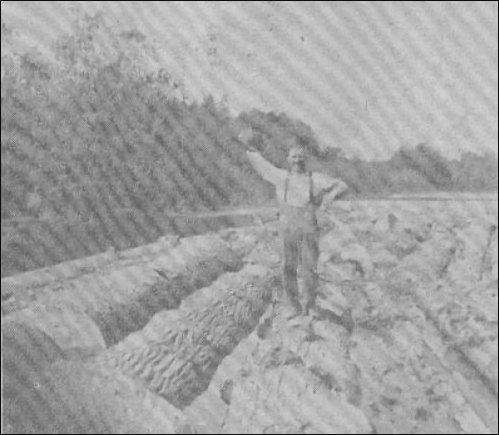
(Log boom)
      In 1946, Art Ward, Sedro-Woolley city attorney, gave this photo to the Sedro-Woolley Courier-Times. It was a reenactment of the old days on Nookachamps creek and the Skagit river across from the old town of Sterling. Back then, loggers cut the old first growth trees and drug them to the creek where they were roped or chained together in booms and floated down to the Skagit and then to the log dump at Riverside near Mount Vernon. Ward noted that such booms were a thing of the past, about 40 years before that. Waving his hat is Otto Boyd. He and his brother, Ruben "Tuffy" Boyd, famous Clear Lake saloon and poolhall operator, brought out four rafts just for the reenactment. Those trees he was straddling were white fir, spruce and cottonwood that were taken from the final stand of timber near the creek. This method was used by loggers all over the Sterling area.
We need more photos of early settlers and their activities. If you have family memories or documents, please email us. If you have scans of photos you want to share, please use this larger email box.

Sterling in the early days
      The village of Sterling was originally centered on a very small area on the north shore of the river. Located just above the juncture of the Nookachamps creek on the south shore, the town was always at the mercy of the Skagit and everyone's schedule was built around the flow of the river. Jesse Beriah Ball moved his logging outfit up from the Steilacoom sometime between 1876-78 and logged in the Burlington area with his sons Warren and David. At that time the area was still in the south half of Whatcom County and Washington was just a territory. Until Mortimer Cook built his general store on the north shore at future Sedro, the little village called Ball's Camp served as the market center for the river east of Mount Vernon. Originally just a logging camp and trading post, the village formed after the log jams were cleared from the bend of the Skagit at Mount Vernon and sternwheelers started regular service upriver.
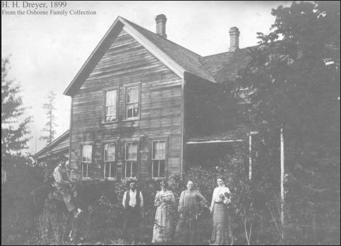
(Dreyer house)
Dreyer house, north Sterling 1899. Harry Osborne collection, via Jeanie Doran Bond


      Although we have not yet discovered why the name of the town was changed from Ball's Camp to Sterling, we did find a logging man by the name of James Sterling in the 1880 census, so he may have been manager of the camp and it may have been named for him. The first reference we have found to the Sterling name is from 1882 when the Army responded to an Indian skirmish and decided to send a detachment upriver to explore the wilderness. That is something we always warn readers and students to be careful about. Lieutenant Henry Hubbard Pierce led his team up the Cascade river and on the way back he traded their horses to local Indians for canoes. In his report he describes the area along the shores: "The Skagit is a beautiful stream, often reminding the traveler of some charming tree-fringed river in New England." Reaching Sterling by sundown, "a mere logging-camp" but a paradise just the same, the ravenous men ate bountiful suppers before retiring amidst the 109 stumps of the "town." [You can read more about the Pierce expedition.] We hedge on this reference to the town name a little, however, because the writer may have been writing from hindsight and applied the subsequent town name to an event of that year. Foiling even our stubborn attempt to find the derivation of the name is the occasional reference to the spelling of Stirling by a couple of early writers. Was that the intended original spelling or just a misspelling?       Several settlers made the section north of Sterling their home in the early days. Lafayette Stevens, a miner, built a cabin on the shore near future Sterling in the period of 1873-75 while he searched for coal in the nearby hills. Wilhelmine von Pressentin talked about staying at his primitive cabin when she and her family arrived to join Karl von Pressentin in 1878. Author George H. Bacon (Booming and Panicking on Puget Sound) noted that Stevens was there in 1889 after Nelson Bennett bought the rights from Stevens to the Crystal coal mine, which later became known as Cokedale.
      After initially living and logging near Minkler Lake, German immigrant Henry Holtcamp (originally Heinrig or Heinrich Holtkamp) homesteaded a mile north of Sterling in the late 1870s and operated a small blacksmith shop for loggers and farmers. His grandson, William Holtcamp, and wife Mildred, who still live on the property, were honored as Founders of the Year at the Sedro-Woolley Museum in 2002. William has written his own fine book about early Sterling. Since Sterling was the first area around Sedro that was logged off, farmers moved in to plant crops in the rich silty soil left behind when the stumps were pulled with help of horses and oxen. Alonzo Salathial Collins, S.H. Lyon and George Wheeler all tilled the fertile soil. Henry Dreyer made the area his permanent home — even after leaving to Oregon for a year or so and then returning, and John Egelkrout established a substantial dairy herd here. Those families and others will be featured in a future story about the settler families of Sterling. (If you are a descendant of one of the families, can you help us with copies of documents or photos?.)
      Two great future leaders of Sedro started in the area around Sterling. Emerson Hammer, future judge and state senator, arrived in early 1889 and took over management of Mortimer Cook's Sterling store. They sold everything from staples to logging supplies to wagons and buggies. In a 1953 interview, his son and partner in the Oliver Hammer Clothes Store, George Hammer, recalled:


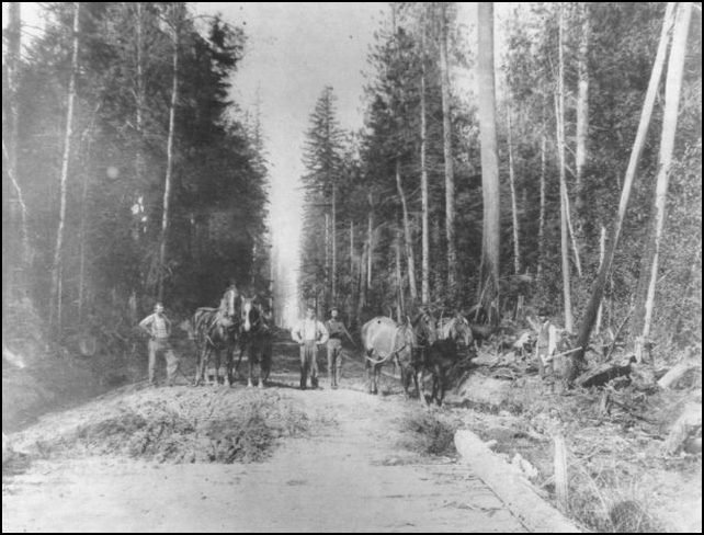
(Cook road)
Cook Road, at the north end of the Sterling district, consisted of back-breaking work by laborers who had to fell many trees and fill in gully-sized potholes, circa 1910. Courtesy of Diz Schimke.

      "We came to Washington Territory in 1889 and on March 1 I started running the Skagit Railway and Lumber Co. store in old Sterling. Mortimer Cook had just bought the stock."
      "In the summer of 1890, Indians all over US were having sun dances and talking of uprising and killing the whites," Hammer recalled. "I took the Seattle P.I. [the Post Intelligencer was then a weekly, delivered by sternwheeler steamboat]. Local Indians would gather around when the paper was delivered. I would read and translate the stories and they were much excited. I had learned to speak Chinook by this time."

Emerson's son, George, was born on June 9, soon after the newlyweds, Emerson and Isabel, arrived from Kansas. Emerson managed Cook's Sterling store until 1891 when he opened a branch of the Sedro Mercantile store on Orange avenue in Burlington and helped his father-in-law George Green open the first shingle mill where the National Cannery later stood. From research of the family, we have discovered that 1891 was the year that Green and his other son-in-law, David Parker, moved here from Lincoln Center, Kansas, the tiny town that Green founded in 1870. Eventually, many families followed them, eventually adding 75 new settlers and family members to Sedro-Woolley and Skagit County, the most of any town we have discovered.
      In 1902 the future leader of Sedro-Woolley industry bought a farm at Sterling. David G. McIntyre moved there from Superior Wisconsin, where he had helped pave the city and install its lighting system. After a few months on the farm, McIntyre became interested in John Anderson's infant Sedro-Woolley Iron Works. Within 16 years McIntyre owned the whole business and eventually transformed logging and expanded to markets all over the world. This story will soon be changed to this address. If neither file connects, please email us.


Skagit River showed Sterling who was boss

For many personal and family memories, we strongly suggest that you look for William Holtcamp's book on Sterling.

      When I first started researching about the Skagit river itself, I read often about DeBay Island, but had no idea where it was, just that it was not there any more. I knew it was near the home of my old schoolmate, Leonard Halverson, but it took me at least a half dozen visits and his patient explanations for me to finally place it. Halverson's family has lived on Lafayette Road near the original townsite of Sterling since way before World War II. He recalls his father's story of when driftwood and logs would lodge in the river channel so high that he could walk over the partially submerged crags to the island, a very large mound of silt and sand that formed in the 1920s in the middle of the river. The island was named for Joe DeBay, an Italian Immigrant. See Chapter 3 here about DeBay's family, the accident which cost him his hand and photos of the old homestead.
      The Skagit river now flows southwesterly from the site of old-Sedro. Back in the early days, however, it made a sharp northern meandering bow up nearly to where the Seattle & Northern tracks ran west to east.

      In the early 1890s there was a horseshoe bend [now called Hart's Island] in the Skagit River a couple of miles west of town that was rapidly cutting away the bank and approaching the [S&N] track. After considerable work in 1897, we secured an appropriation of $35,000 from Congress, the cost estimated by the army engineers for a channel through the southern neck of the peninsula, but with a rider attached that required us to secure waivers of damage from all owners of property abutting on the river for five miles down the river below the proposed cutoff. It was impossible to do this so the appropriation lapsed. The river continued cutting deeper in the bend and by 1908 had washed away hundreds of acres of good farming land and reached the Great Northern [formerly the S&N] Railway, which had to..
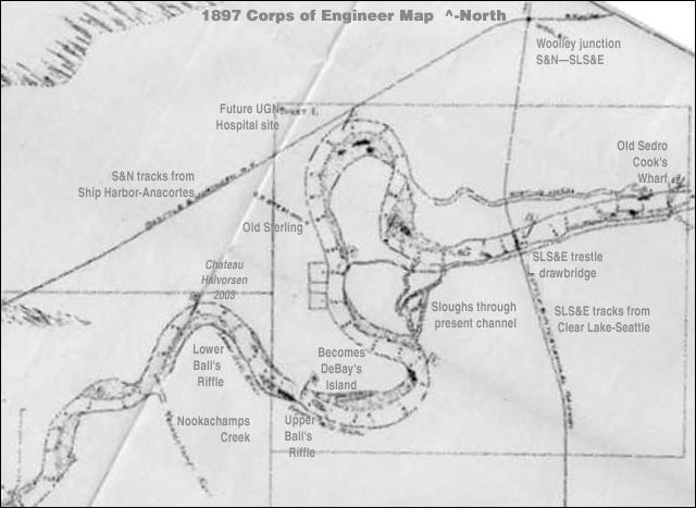
There the diary ends. The river kept eating away the northern bank, especially in flood years like 1896 and 1897 [see Mother of all Floods]. The next major flood occurred in 1909, causing much damage in the Sterling and Nookachamps Creek area and breaching a dike near Burlington. Michael Aiken, a descendant of Birdsview and Lyman pioneer Birdsey Minkler, owns a rare map that was drawn by the Army Corps of Engineers after the massive floods of November 1897. In the accompanying report, the writer discusses the nature of the double-horseshoe bend by the river's main channel then at Sterling and the sloughs that were forming. Those sloughs eventually became the main channel that we see today, which basically extends the channel from east to west. This story will soon be changed to this address. If neither file connects, please email us.
      Halverson remembers the stories of government engineers blasting a hole through the neck of the peninsula during a flood in 1911. They went ahead and implemented this emergency procedure without authorization of the farmers downriver as the rider of 1897 had suggested.


(The Sterling Bend map)
      The U.S. Corps of Engineers commissioned this map after the three devastating floods of 1894, 1896 and 1897. This 1897 map was discovered by Mike Aiken of Mount Vernon among the papers of his famous upriver ancestor, Birdsey Minkler. You can see the double horseshoe bend. The old channel around the upper bend is now a slough that forms Hart's Island. The lower bend hooked around Joe DeBay's property. The river eventually ate through almost due west and eventually formed DeBay's Island between the main channel and a slough around the lower bend. That lower channel is now a dry slough.

      "The first time the river cut all the way through what is now the main channel was during the flood of [Dec. 12-13] 1921," says Halverson. "Although each flood would cut the present channel wider, it was completely plugged up by a log jam within months in 1921, with submerged logs, buildings that has washed down and boats. Each summer farmers on the south side of the present river channel would set the jam afire in one spot and then another. Finally, in about 1932, it all washed away. I can remember one of the DeBay boys telling me that he walked home with a lantern from our house across the log jam the last night before it washed away, and could feel the logs coming loose below his feet."
      In 1936, DeBay told Catherine McClintock of the Courier-Times that it was in the big flood year of 1921 when the river began eating through the neck of the peninsula and isolated part of Joe DeBay's farm as an island with the new channel of the river on the northwest and another channel cutting through on the southeast. Successive floods in 1923 and '24 deepened the main channel and DeBay Island was formed, with Joe's farm as the dominant feature.
      That didn't deter DeBay from marketing the vegetables and fruit from his abundant farm. For 11 years, he and his family used a primitive ferry to transport goods to and from the island until he induced the county to build a wooden bridge to their place from the eastern direction and Francis Road. On Sept. 22, 1935, the bridge was opened and the DeBay family staged a grand picnic, inviting friends and customers from all over the county to share their bounty and their wine.
      Ken Johnson, who owned part of the DeBay homestead for about 20 years, recalls that the original bridge, which connected DeBay Island on the east with Francis Road, was replaced about 30 years ago because it was built way too low. The county built a new bridge, put an extensive culvert in and raised the road much higher. The southeastern channel that created the island is pretty much a dry slough today. Johnson notes that the original DeBay homestead was at the west end of the island. After a fire, DeBay moved to higher ground at the eastern part of the island in the '30s.


Sterling after the turn of the century
    Any time, any amount, please help build our travel and research fund for what promises to be a very busy 2011, traveling to mine resources from California to Washington and maybe beyond. Depth of research determined by the level of aid from readers. Because of our recent illness, our research fund is completely bare. See many examples of how you can aid our project and help us continue for another ten years. And subscriptions to our optional Subscribers Online Magazine (launched 2000) by donation too. Thank you.


(Plumeria)
We recently visited our newest sponsor, Plumeria Bay, which is based in Birdsview, just a short walk away from the Royal family's famous Stumpranch, and is your source for the finest down bedding. See our Journal feature on this local business and learn more details and how to order items at their website.

      According to the book, Skagit Settlers, Sterling in the 1880s had a hotel, a church and the omnipresent saloon. But contrary to that and other histories, the town did not dry up and blow away after the area was clear-cut. Sterling was still very active in 1905, when the old Sterling Mill was leased out and brought back into full production. James Ritchford was the partner along with William Hurley in the Hurley, Marshall & Ritchford Company, which revived the mill. The reason for the mill's rebirth was that it became the terminus for the new Puget Sound & Baker River Railway. The organized that year by the Dempsey Company of Michigan and local timber magnate Ed English of Mount Vernon to transport logs cut on Lyman Hill after Great Northern raised its rates dramatically.
      Ritchford's family farm north of Sterling was ripped to pieces in the late-'90s floods, especially that of 1896, when they had to move away temporarily after their house was demolished by floodwaters. Ritchford is half of the most puzzling genealogical puzzle we have yet encountered. In the 1906 Illustrated History book, Ritchford's biography is identical to that of Woolley George W. Ratchford up to the time that both left Ontario, Canada, in 1883 to work in California. Amazing coincidence? You can read their story at our website. No, they were brothers, but even their present-day descendants did not know they were related. We hope that someday a descendant can relate this serious family schism. This story will soon be changed to this address. If neither file connects, please email us.
      Halverson's house stands on Lafayette Road, almost exactly where the original Sterling Saloon stood. The actual town of those days was built on high ground, east across the fields from his house. We suspect that each flood moved the center of the town further above the shore. When the Pressentins arrived in 1877, Lafayette Stevens was living right on the shore. Halverson recalls that he and his father tore down the old anchor pole for the ferry that crossed the Skagit about 200 yards from his house at what was called the lower-Sterling Riffle, the last stop for steamboats when the river was low, such as it was in March 2001.
      The area north from the town was the first large acreage upriver to be extensively cleared in pioneer days and agriculture began to take over from timber as the main factor of the economy after the turn of the century. When the Interurban line was extended to Sedro-Woolley in 1912, two stop stations were built just south of present Hwy. 20. One was called Sterling, just across from the present road that continues north to United General hospital, and at Kimsey, a couple miles west. As the river carried away more of the north shore, including much of the original village and settlement, the old town faded and most people came to think of the train stop as Sterling. Nowadays folks consider the Sterling area to encompass the farm of the pioneer Holtcamp family on the east to Sterling Hill on the west and up to Cook Road on the north. No matter which area of Sterling that the descendants of those early Sterling pioneers grew up on, they meet annually for a picnic as one big family. Their reunions are a wonderful affair. There are many families whose heritage lies north of the original town of Sterling. We will honor them in a future additional story that we will call Sterling Depot North.
      There is a beautiful and appropriate happy ending to the DeBay part of the story. In the 1990s the state department of wildlife bought a large portion of the original property and last year a preserve for swans was created. It is accessed by an extension of the Francis Road that crosses the DeBay dry slough on the south side of the Skagit. My first memory as a child was of riding in my parents' old 1946 Plymouth to see and hear the trumpeter swans near our rented home east of Mount Vernon. I can just imagine the first time Joe heard their unique call in the winter of 1890 and decided that this was the refuge he sought when he left Italy for the New World in 1889.


Questions we have about Sterling:
      There are still some gaps in our story and we would love to know more about Sterling over the years and see scans or copies of any photos you might have. We thank Allen Lyons and Marsha DeBay Lyons for their wonderful family photos, along with Marie Barbo Sims. And we thank Susan Shoemaker and Sharon Calabrese-Winterburn, the descendants of Jesse Beriah Ball, who helped so much with photos and family memories. And Jeanie Doran Bond, descendant of both the Dreyer and Osborne families, has contributed school information. But these questions remain for further updates:

Links, background reading and sources

Story posted on Story posted Sept. 1, 2001, updated on March 15, 2004, moved to this domain Nov. 10, 2011
Please report any broken links so we can update them
This article originally appeared in Issue 19 of our Subscribers-paid Journal online magazine


Getting lost trying to navigate
or find stories on our site?
Read how to sort through our 700-plus stories.

See this Journal Timeline website of local, state, national, international events for years of the pioneer period.
Return to the new-domain home page
Links for portals to subjects and towns
Newest photo features
Search entire site
Our monthly column, Puget Sound Mail (but don't call it a blog)
debuted on Aug. 9, 2009. Check it out.
(bullet) Remember; we welcome correction & criticism.
(bullet) Please report any broken links or files that do not open and we will send you the correct link. With more than 700 features, we depend on your report. Thank you. And do not give up if you find a link that seems to be closed. Just put the subject in the search box below. The story may have been moved to our new domain. Or just ask us and we will guide you to it.
(bullet) Did you enjoy this story? Remember, as with all our features, this story is a draft and will evolve as we discover more information and photos. This process continues until we eventually compile a book about Northwest history. Can you help with copies or scans of documents or photos? We never ask for your originals.
(bullet) Read about how you can order CDs that include our photo features from the first ten years of our Subscribers-paid online magazine. Perfect for gifts. Although it was delayed by our illness, it is due for completion in 2012.

You can click the donation button to contribute to the rising costs of this site. See many examples of how you can aid our project and help us continue for another ten years. You can also subscribe to our optional Subscribers-Paid Journal magazine online, which celebrated its tenth anniversary in September 2010, with exclusive stories, in-depth research and photos that are shared with our subscribers first. You can go here to read the preview edition to see examples of our in-depth research or read how and why to subscribe.

You can read the history websites about our prime sponsors
Would you like information about how to join them in advertising?

(bullet) Our newest sponsor, Plumeria Bay, is based in Birdsview, just a short walk away from the Royal family's famous Stumpranch, and is your source for the finest down comforters, pillows, featherbeds andduvet covers and bed linens. Order directly from their website and learn more about this intriguing local business.
(bullet) Oliver-Hammer Clothes Shop at 817 Metcalf Street in downtown Sedro-Woolley, 90 years continually in business.
(bullet) Peace and quiet at the Alpine RV Park, just north of Marblemount on Hwy 20, day, week or month, perfect for hunting or fishing. Park your RV or pitch a tent — for as little as $5 per night — by the Skagit River, just a short drive from Winthrop or Sedro-Woolley. Alpine is doubling in capacity for RVs and camping in 2011.
(bullet) Check out Sedro-Woolley First section for links to all stories and reasons to shop here first
or make this your destination on your visit or vacation.
(bullet) Are you looking to buy or sell a historic property, business or residence?
We may be able to assist. Email us for details.

Looking for something special on our site? Enter name, town or subject, then press "Find" Search this site powered by FreeFind
    Did you find what you were seeking? We have helped many people find individual names or places, so email if you have any difficulty.
    Tip: Put quotation marks around a specific name or item of two words or more, and then experiment with different combinations of the words without quote marks. We are currently researching some of the names most recently searched for — check the list here. Maybe you have searched for one of them?
Please sign our guestbook so our readers will know where you found out about us, or share something you know about the Skagit River or your memories or those of your family. Share your reactions or suggestions or comment on our Journal. Thank you for taking time out of your busy day to visit our site.

View My Guestbook
Sign My Guestbook
Email us at: skagitriverjournal@gmail.com
(Click to send email)
Mail copies/documents to Street address: Skagit River Journal, 810 Central Ave., Sedro-Woolley, WA, 98284.