Site founded Sept. 1, 2000. We passed 3 million page views on Feb. 10, 2009
These home pages remain free of any charge. We need donations or subscriptions to continue.
Please pass on this website link to your family, relatives, friends and clients.

(S and N Railroad)

Skagit River Journal

of History & Folklore
Free Home Page Stories & Photos
The most in-depth, comprehensive site about the Skagit

Covers from British Columbia to Puget Sound. Counties covered: Skagit, Whatcom, Island, San Juan, Snohomish & BC. An evolving history dedicated to committing random acts of historical kindness
Noel V. Bourasaw, editor (bullet) 810 Central Ave., Sedro-Woolley, Washington, 98284
Home of the Tarheel Stomp (bullet) Mortimer Cook slept here & named the town Bug

(Click to send email)

Photos of Big Four Inn and old Snohomish County
Darrington History Show, Oct. 25, 2008

By Noel V. Bourasaw, editor of Skagit River Journal

This page contains photos below that we exhibited at the Darrington History Show. We will be expanding the section later in 2009 to include extensive memoirs and stories of the Bedal sisters and Nels Bruseth. Email us and we will put you on the bulletin list. If you are looking for the Blanket Bill Jarman show, see this site.

      I am honored to be invited by the Darrington Historical Society to present a history photos show at the Mansford Grange in Darrington from 1:30-4:30 p.m., on October 25. Here is a disclaimer, however, I am not an "expert" and I will not be "lecturing" about your Snohomish County history. What I will do is share some research about your pioneers and writers who almost fell through the cracks of history.
      The format for the show will be simple. It will be completely interactive. Both the society and I urge you all to bring your scrapbooks, photos and documents from your collections to show before, during and after the show. And we urge you to talk to your neighbors who are old-timers and ask them for stories and photos that may have never been published before. We especially hope that you can identify and urge to attend the descendants of pioneers from Darrington, Monte Cristo and the Sauk/Suiattle River area. I especially want to learn from you and other guests about the mining phenomenon that attracted the attention of heavyweights like the Rockefellers to Snohomish and Skagit counties in the roaring 1890s. We will have more than an hour at the end for follow-up questions, for people to share their scrapbooks and for discussion from area authors who attend.
      I plan to address the following people who were seminal in participating and writing about that fascinating period: Sam Strom, Nels Bruseth, all the Bedals and Alice Elinor Lambert, who lived to nearly 100 and helped remind people in Darrington about their history during the period of 1949-75 when history and genealogy was not deemed as important as it is today. If any of you know any of their descendants, please let us know and please invite them. We also hope to find, observe and copy any paintings by Nels Bruseth that are in private collections in the Darrington area. Can you help direct us to them while we visit from Oct. 24-25?
      I will also draw attention to Elizabeth Poehlman's terrific book, Darrington Mining Town/Timber Town, and the equally fine books by the writing team of Daryl Jacobson, Phil Woodhouse and Victor Pisoni: Discovering Washington's Historic Mines, Vol. 3, The Northern Cascade Mountains; and Everett and Monte Cristo Railway. Both books will soon be extended into a second printing. In addition, we will draw from Phil Woodhouse's seminal area history, Monte Cristo.
      We hope you will visit our website free home page, http://www.skagitriverjournal.com , now in its eight year with 2.5 million page views; and our portal section to our extensive Snohomish County history list:


      We plan to show a series of historic photos. Below we share some photos loaned by author Paul Dorpat, from the collection of Fred Cruger. We hope that one of our readers can help us identify these scenes and/or the people in them. You will see a thumbnail of the photo at the left in the table below, with a brief description of everything we now know. Just click on the thumbnail for a large, full-size version. Please respond by email if you can help, citing the number of the photo in question. Thanks for your help.

(Big Four Inn 1)
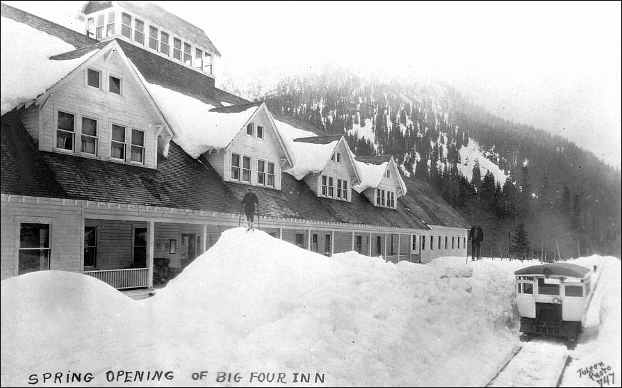
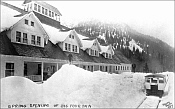
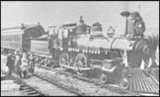
1. Big Four Inn Spring Opening, probably 1927. With a speeder on the railroad tracks. Can you tell us more about the Inn? Does it still exist? About the railroad and the speeder? In what direction are we looking? The photographer imprint is handwritten, Juleen, Number 747.
      Fred Cruger notes: That's actually a full-sized Hartford-Eastern rail car arriving at the Inn, which was located right on the tracks near the base (north side) of Big 4 Mountain. Built by the Rucker Brothers immediately after they purchased the trackage from the Northern Pacific in the early 20s, the Inn burned to the ground in 1949. The Granite Falls Historical Museum has lots of interior and exterior pictures of the Inn. The Forest Service maintains a well-kept picnic area at the site of the Inn, where the main fireplace is the only remaining evidence of the building. We're looking West in this picture, toward civilization.

(Big Four Inn 2)
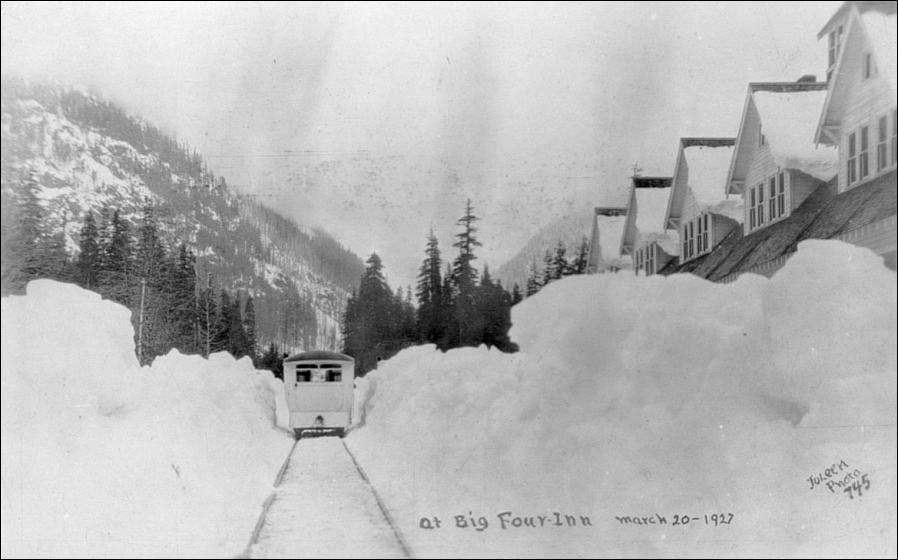
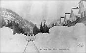
2. Big Four Inn Spring Opening, March 20, 1927. With a speeder on the railroad tracks. Can you tell us more about the Inn? Does it still exist? About the railroad and the speeder? In what direction are we looking? The photographer imprint is handwritten, Juleen, Number 745.
      Fred Cruger notes: In this picture, we are looking East, toward the Cascades and up the track to Monte Cristo. John A. Juleen was a well-known Everett photographer and took many of the historic photos that have been preserved in the area.

(Big Four Inn 3)
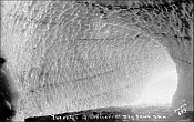
3. Interior of a glacier near Big Four Inn. Do you know where this might have been? The photographer imprint is handwritten, Juleen, Number 689.
      Fred Cruger notes: This is a shot from inside the Ice Caves at the base of Big 4 Mountain. There is a well-kept trail leading from the site of the Big 4 Inn to the Ice Caves, but heavy flow washed out the main bridge that crosses the Stillaguamish just 1/2 mile from the Inn. The large laminated bridge girders were saved, and anchored near the bridge site, so repairs will hopefully happen in 2009. It's interesting to see women in long dresses hiking into the ice caves in some of our old photos.


(Monte Cristo 1)
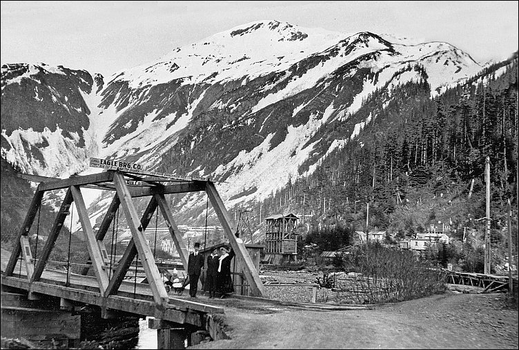
4. A bridge apparently newly constructed by the Eagle Bridge Co. near the town of Monte Cristo or was it the town of Mineral City. Do you know about the company? Was it built over a canyon or creek or river? What direction are we looking in? Can you identify the mountain in the background? Any guess as to the year?
      Fred Cruger notes: This is definitely not Monte Cristo, but I guess there is some possibility that it's Mineral City (although I've not been able to confirm that). There is an interesting beer advertisement on the bridge, as I recall.

(Monte Cristo 2)
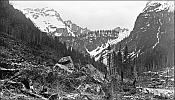
5. A scene near the town of Monte Cristo. Using the concentrator at the right, what direction are we looking in? Can you identify the mountain in the background and to the right? Any guess as to the year?
      Fred Cruger notes: The distinctive rock at the center of this photo is one of the few remaining items in Monte Cristo that can be found easily. We have a picture that shows that rock in 1893, 1948, and 2003, all three shots taken from essentially the same spot looking southeast. This picture is unique in that it shows the rock while we're looking roughly northeast. The mountain on the right is Wilman's Peak, dominant in most early Monte Cristo photos. This picture was likely taken in the mid- to late-1890s.

(Monte Cristo 3)
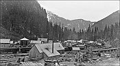
6. This is a stunning view of the town — Mineral City or Monte Cristo? Thank you, Paul and Fred. Can you tell what direction are we looking in? Can you identify any of the buildings or details of the railroad?
      Fred Cruger notes: This is Monte Cristo. The building dominating the picture is a lumber mill that ultimately became the Monte Cristo depot. The railroad water tank and turntable are at the left (the turntable is still there, and one of the few significant items besides the rock mentioned above that remain and can be easily identified by a casual visitor). In this view we are looking northwest down the tracks to Barlow Pass and civilization. When you hike in Monte Cristo today, you are hiking along the railbed that disappears into the rear center of the picture.

(Monte Cristo 4)
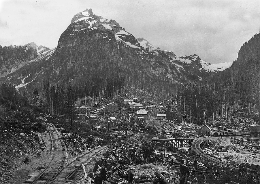
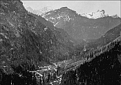
7. Can you identify the mountains around the valley in the center? What direction are we looking in?
      Fred Cruger notes: This great view is looking down on Monte Cristo in a west-northwest direction (in my mind). If you look closely in a high-resolution version, you can see the depot and water tower, and the tracks to Barlow Pass follow the valley out of the picture. There is a long narrow wooden structure snaking its way out of the large concentrator at the lower left end of town - that structure is the cover over a horse-drawn tram that carried ore from where it was delivered by cable tram from mines on the mountain from which this picture was taken. There is a siding from the mainline that winds toward the concentrator from a switchback on the right side of the town in this picture.

(Monte Cristo 5)
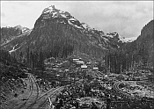
8. Another stunning view of the town — Mineral City or Monte Cristo? Can you identify the mountains in the background? What direction are we looking in?
      Fred Cruger notes: Now we're looking straight at Wilman's Peak (southeast, in my mind) and the town of Monte Cristo. The mainline enters the picture at the lower right, and curves down to the depot, water tank, and turntable. There's a switchback that comes back up the hill to where we're standing, and a siding that then takes off in a winding route to the big concentrator. This is a classic view of Monte Cristo, and clea rly shows that unique rock I mentioned earlier, just off to the side of the switchback, near the center of the photo.

(Milepost)
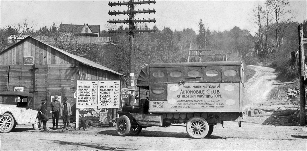
9. This is a fascinating photo of a milepost. Can you determine where it was? The year? The Denby truck? The Frank Waterhouse Company?
      Fred Cruger notes: This was taken at a spot that now would be on the east end of the trestle Hwy 2 now crosses the flats from Everett toward higher ground at Cabellero (sp?) Hill. Denby made a lot of trucks. I may have an approximate date for this somewhere, and probably gave a good guess to Paul Dorpat.


Links, background reading and sources

Story posted on Oct. 1, 2008, last updated June 19, 2009
Please report any broken links so we can update them


Return to the new-domain home page
Links for portals to subjects and towns
Newest photo features
Search entire site
(bullet) See this Journal website for a timeline of local, state, national, international events for years of the pioneer period.
(bullet) Did you enjoy this story? Remember, as with all our features, this story is a draft and will evolve as we discover more information and photos. This process continues until we eventually compile a book about Northwest history. Can you help?
(bullet) Remember; we welcome correction & criticism.
(bullet) Please report any broken links or files that do not open and we will send you the correct link. With more than 550 features, we depend on your report. Thank you.
(bullet) Read about how you can order CDs that include our photo features from the first five years of our Subscribers Edition. Perfect for gifts.

You can click the donation button to contribute to the rising costs of this site. You can also subscribe to our optional Subscribers-Paid Journal magazine online, which has entered its ninth year with exclusive stories, in-depth research and photos that are shared with our subscribers first. You can go here to read the preview edition to see examples of our in-depth research or read how and why to subscribe.

You can read the history websites about our prime sponsors
Would you like information about how to join them?

(bullet) Oliver-Hammer Clothes Shop at 817 Metcalf Street in downtown Sedro-Woolley, 88 years.
(bullet) Peace and quiet at the Alpine RV Park, just north of Marblemount on Hwy 20, day, week or month, perfect for hunting or fishing
Park your RV or pitch a tent by the Skagit River, just a short drive from Winthrop or Sedro-Woolley
(bullet) Joy's Sedro-Woolley Bakery-Cafe at 823 Metcalf Street in downtown Sedro-Woolley.
(bullet) Check out Sedro-Woolley First section for links to all stories and reasons to shop here first
or make this your destination on your visit or vacation.
(bullet) Are you looking to buy or sell a historic property, business or residence?
We may be able to assist. Email us for details.

Looking for something special on our site? Enter name, town or subject, then press "Find" Search this site powered by FreeFind
    Did you find what you were seeking? We have helped many people find individual names or places, so email if you have any difficulty.
    Tip: Put quotation marks around a specific name or item of two words or more, and then experiment with different combinations of the words without quote marks. We are currently researching some of the names most recently searched for — check the list here. Maybe you have searched for one of them?
Please sign our guestbook so our readers will know where you found out about us, or share something you know about the Skagit River or your memories or those of your family. Share your reactions or suggestions or comment on our Journal. Thank you for taking time out of your busy day to visit our site.

View My Guestbook
Sign My Guestbook
Email us at: skagitriverjournal@gmail.com
(Click to send email)
Mail copies/documents to Street address: Skagit River Journal, 810 Central Ave., Sedro-Woolley, WA, 98284.