Site founded Sept. 1, 2000. We passed 4 million page views on May 17, 2010
Please pass on this website link to your family, relatives, friends and clients.

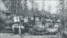
(SLSE Railroad)

Skagit River Journal

of History & Folklore
600 of 700 total Free Home Page Stories & Photos
The most in-depth, comprehensive site about the Skagit

Covers from British Columbia to Puget Sound. Counties covered: Skagit, Whatcom, Island, San Juan, Snohomish & BC. An evolving history dedicated to committing random acts of historical kindness
Noel V. Bourasaw, founder & editor (bullet) Sedro-Woolley, Washington, 98284
Home of the Tarheel Stomp (bullet) Mortimer Cook slept here & named the town Bug

(Click to send email)

Where was Skagit City?
 

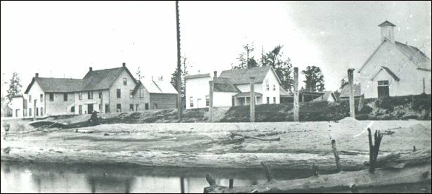
(Skagit City)
      Skagit City was located on the South fork side of the Skagit River, less than a mile southeast of where the river forks north and south. Tom Robinson drove me to the very spot a couple of years ago and the bank is never covered with ferns and brambles where these buildings stood circa 1890-1900. The town began near where Barker's Trading Post opened in 1869. Within ten years, most of these buildings cropped up as Skagit City became the major crossroads for trading in the area that became Skagit County in 1883. During the 1870s, hotels, stores, saloons, a school, church, the Good Templars and Masonic lodges and other businesses were built to accommodate those who were claiming land above the river's log jams located where Mount Vernon is today. When those jams were cleared in the late 1870s , the town declined as other villages formed along the upper stretches of the river and sternwheelers ascended the river as high as Sterling and Hamilton, depending on the depth of the river. By 1906, only one building remained — the general store of Daniel E. Gage, the building at the far left. John G. Kamb Jr., a descendant of two pioneer families on Fir Island, showed us a faded copy of this photograph at the Skagit City School that does not have a date but the old handwriting on it indicates that it was from the 1920s or 1930s. It noted that the Gage store was the only one still standing at the time of the notation. Besides the store, the note indicated that the church at the far right was Baptist in affiliation and that the large white house in the center was the home and office of Dr. Thompson.


Skagit City was once the center of local business and activity by Mari Densmore of Skagit County Historical Society & Museum

Article from recent series published by Skagit Valley Herald titled: Skagit's Lost Communities, which in turn is based on the museums exhibit, 'Lost Cities of Skagit County'


See details of the July 17, 2016 planned picnic.... and here

      One of the most prevalent questions we get from readers is: "Where is Skagit City?" That's a logical question, since that village is the one mentioned most often in early Skagit County-mainland history, pre-1884, yet the location is rarely pinned down. Readers want to know where they can see the remnants of it. First of all, the townsite is long gone, so there is no is. It had faded as a market center a century ago and most vestiges disappeared by World War II. After Mount Vernon was founded in 1877, about three miles upstream, and a path was carved through the two logjams by 1878-79 (see below), Skagit City's importance as a terminus for sternwheeler travel ended and the town became more of a social center than a market center. Those social bonds were broad and deep and were still in evidence a century after the town debuted.

In 2010, NW Washington History Detectives meet-up is staged to revive interest in this very historic area and to help save the school from the wrecking ball. As with all our meetings, we ask guests to bring a potluck dish and there will was a $3 donation for administrative and organizing costs. We will coordinate this meet-up with the board of the school building and local organizations, and the help of John G. Kamb Jr. and Solveig Lee, who know the area very well. We ask guests to bring photos and scrapbooks and documents of the forks of the river, Fir Island, Skagit City and the surrounding area. Children are very welcome and we hope to have activities especially for them. See the NW Washington History Detectives link for details of the meet-up and a link that explains you optionally choose to join the group for free.

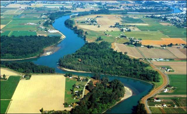
      A few years ago, author Tom Robinson and I traveled to the Forks area on the Skagit and we walked down to where we think that the village first bloomed in about 1872, a few hundred yards south of the break of the north and south forks. All we found was a collection of ferns, alder and nettles near the levy. John G. Kamb and I returned there in May 2007 and agreed on the same site. When you look at the aerial photo below, you will see a sand bar jutting out into the South Fork that looks suspiciously like the beach in front of the buildings in the historic Skagit City photograph above. Up until now, I have answered readers by referring them to a number of links in the Journal and elsewhere. In this issue, I have gathered together bits and pieces from those links and combined them with our research. Readers can also follow links to the individual stories to see more about the land itself and the pioneers who broke their backs as they settled there, a decade before Skagit County broke off from its mother, Whatcom County. This story will evolve, as all our features do, and it is now up to you to help us expand the story. Do you have photos or articles or diaries or letters or any documents from your family collection that you can copy for us? We never ask for your originals. Copies or scans will suffice. As with all our features, we annotate these stories with information in [ ] brackets.


Journal research . . . Eldridge Morse's Northern Star, 1876
Morse article 1877 . . . Washington Standard 1876
Washington Standard 1877
. . . 1906 Illustrated History


Skagit River Journal research about Skagit City

Barker and Campbell trading posts
            For those not familiar with Skagit City, it was a small village near the fork of the Skagit River, about three miles south of future Mount Vernon on the western shore of the South Fork. The South Fork was the main channel of the river for transportation and the North fork flowed west-southwest into a series of sloughs on the delta.
      Researchers have concluded that the location of the village in its genesis may have varied, depending on the location of various trading posts and steamboat landings. We know from the 1906 [Illustrated History of Skagit & Snohomish Counties that John Barker established a trading post somewhere near the fork of the Skagit in 1869, maybe at the same place that John Campbell had a similar post a year earlier. From the 1906 book:

      At that early day Skagit City seems to have been the center of operations. At the Union hall in that place all manner of public assemblages, religious meetings, political conventions, entertainments, Good Templars' [prohibitionist] meetings, balls and socials, festivals and fairs were accustomed to gather. The Skagit City of that time was about half a mile above its present location. It seems to have been the general rendezvous for canoes, scows, booms of logs, and steamboats in so far as they appeared at all. The removal of the big jam from the vicinity of Mount Vernon a few years later [1877-79] destroyed the prestige of Skagit City. . . .
      A man named Campbell, in 1868, established a small store at the forks of the river, where he kept and disposed of the standard goods for cash, a rather large amount of the latter being necessary to effect a trade for such patrons as had run out of the their regular store. This pioneer storekeeper of the Skagit had the untoward habit of spirituous imbibition to an unhealthy degree. On one occasion when he had reached a satiated condition, in his strenuous efforts to handle a barrel of sugar, which constituted his whole stock in trade, he managed to dump it in the river and to follow it immediately himself. A Siwash, who was not quite so drunk, extricated him from the watery depths. After some tedious work the barrel of sugar was also landed. It had absorbed so much water as to be turned to molasses, in which condition he disposed of it at advantageous prices to the hungry Indians. Campbell soon disposed of his mercantile interests to J.J. Conner, and he in turn sold out to [Daniel] E. Gage, who is still engaged in merchandising at Skagit City. . . .
      For a new region the Skagit valley seems to have been somewhat singularly free from affrays and crimes. The only recorded murder of very early date occurred at Skagit City in the winter of 1869-70. A certain trader named John Barker had come to the valley during the previous year and had erected a shake shanty on the island near the junction of the forks. Among other merchandise which Barker dealt was the ever-present and ever-destructive whiskey, with which he supplied whites and Indians alike. Immediately across the north fork a band of Indians had established themselves and made some small clearings upon which were erected rude huts. One morning Barker was found lying in his shanty, his throat cut and his store ransacked. Shortly afterward some goods supposed to have been a part of the stock were found in the possession of Quinby [some sources spell the name as Quimby] Clark, who lived near, but before any investigation had been undertaken, Clark left the region. It is said that some of the south forkers formed a a mob in the meantime and hanged two Indians, supposing them to be the guilty parties. It appeared by subsequent investigation that Clark had shortly before wanted to get a squaw for whom thirty dollars was demanded. and that right after the murder he raised the necessary money. Also a subsequent investigation of the store showed plainly that the robbery and murder had been committed by a white man, for things which Indians would have taken were left and those which a white man would have taken were gone. Barker had been a Mason and the members of this fraternity spent three years in seeking the supposed murderer, but without avail.

      Here we share a suspicion that author Tom Robinson and I both have expressed about the treatment of both Indians and John Campbell by the authors of the 1906 Illustrated History. Siwash, a Chinook Jargon word, was derived from the French word, sauvage, and eventually became a term applied to all Indians, to their consternation, and it soon became a derogatory term. Some still employ the term that way. Campbell is also generally treated with contempt. As Robinson noted, the derogatory implications about Campbell may have been a smear job by his neighbors who were staunch Republicans and opposed to Campbell, one of the minority Democrats in the early settlers. We must remember that he appeared just years after the Civil War surrender at Appomattox. Robinson also wonders what the connection might have been between Campbell the storekeeper and the Swinomish Indian Johnny Campbell. We also wish that the authors had been more careful to distinguish between the Campbell and Barker trading posts, if indeed they were distinctly different, and we wish they had been more careful about their locations. Robinson discusses that further below.
      The most slanderous accusations about Campbell, however, appeared in a story in the book, Skagit Settlers that Joseph F. Dwelley based on a memoir by LaConner hotel owner John P. McGlinn. Also the federal Indian agent, McGlinn described a canoe trip that fall of 1874 that terminated at a spot about where William Hamilton's steamboat landing across the Skagit from Coal Mountain was located. McGlinn's canoe party included LaConner founders John S. Conner and his wife, Louisa Ann; Edward Seigfried [probably spelled Siegfried], Mrs. Conner's brother from Pennsylvania; James O'Loughlin, who owned a tin shop there, and his wife; and James Gaches, who started a general store there the year before with his brother and who would become one of the county's most famous early pioneers.

      The last member of the canoe party to Hamilton was John Campbell, a partner in a local trading post, who had impressed McGlinn mightily as a speaker at the LaConner Fourth of July celebration, the summer before. Campbell gave quite a stem-winder of a speech and kept the small crowd of settlers convulsed with laughter. But McGlinn noted that Campbell's prediction of LaConner's future in 1900 "appeared to be... a picture drawn from a too-fervid imagination."
      After the party enjoyed a day of peaceful commune with nature across the river from future-Hamilton, they woke in the night to hear piercing blood-curling shrieks. Campbell had slipped off into the night.
      It was a terrifying moment. The wild and unsettled country, the unearthly shrieks coming at such an hour, and in such a place, completely unnerved them, making the hair on their heads stand and thrilling the blood in their hearts.
      The men set off in the woods and found him shrieking over and over the name of a local Skagit River Indian, "Ted-auh-an." It was all the men could do to restrain him, but after his struggles ceased, he lapsed into a milder form of what McGlinn described as religious dementia.
      The party had planned to continue upriver but the women balked and they certainly did not want to continue up or down in Campbell's company. O'Loughlin saved the day when he tricked Campbell into believing that an Indian courier from Swinomish had arrived with a letter from Catholic Father Chirouse that requested Campbell to return downriver immediately. Campbell fell for the bait. He would not be the last man to go insane while living upriver.

Robinson's theory certainly pertains in that instance because McGlinn was the most prominent Republican appointee in the region. Besides, he was an ardent prohibitionist who did not allow hotel guests to imbibe alcohol. Meanwhile I am still trying to determine if the 1906 book author was right about Campbell's store in 1868 or if Campbell and Conner took over Barker's location sometime in 1870.
      The 1906 Illustrated History also notes that South Fork pioneer Joseph Wilson was connected with John Barker. Wilson originally came to Washington Territory in 1868 and briefly lived in Port Townsend after serving as an American sailor on ships trading with China. He came to Fidalgo Island as a logger in 1868 and then preempted land near the mouth of the South Fork and Dry Slough, a ranch that was later called the "Good place" for another family after Wilson moved to the Skiyou (or Skiou) region east of Sedro-Woolley. In his 1906 book biography he is recorded as having "took what there was remaining of Barker's goods up to Whatcom, the then county seat of the present Skagit and Whatcom counties, in a canoe, and delivered them to the authorities." About five years later, Wilson was one of the key subscribers in the early settlers' effort to cut through the two log jams between present Mount Vernon and the fork of the river. Robinson found evidence that the aforementioned John Campbell, the post owner, was also involved with that log jam removal. He also found that Campbell was involved with Alvin Williamson's hop farm that was on the north side of the Skagit River, just west of future Lyman.


Other Skagit City notes
      A few other details we have established about Skagit City include the fact that a post office opened at the Daniel Gage store in Skagit City on April 24, 1872, and was discontinued on March 15, 1904.The seminal fact about Skagit City, however, is its function as a terminus below the log jams for the early sternwheelers that established a trade route between Seattle and southern Puget Sound with the Skagit River.
      The 1906 book and other sources note that this trade was associated early on with the sternwheeler Fanny Lake, which began the route on 1874. That is at odds with other accounts, however, that establish that the Fanny Lake, a 100-foot boat, was actually launched at Seattle in 1875, the first boat built by the T.W. Lake shipyard. Lake was born in Norway in 1825 and he named the boat for his wife. It was designed with a draft shallow enough to float on a "heavy dew, resisting the groundings of other steamboats on Northwest rivers. It was originally operated by a company called Diggs & True on the Duwamish and White rivers. With its locomotive boiler and two small single-cylinder steam engines, the economical steam winch and hoisting gear, the owners soon determined that it was perfect for the run to the Skagit River. An attached scow could be poled even further for light freight. The captain was named in various sources as either John S. or A.S. Hill and he soon made regular runs between Seattle and Skagit City to deliver freight and mail for all upriver points. On May 21, 1883, the boat sank at Dead Man's riffle, just east of future old Sedro and all of the upper works were destroyed. But six years later, young Joshua Green and his partners in the new La Conner Trading and Transportation Co. resuscitated the Fanny Lake to transport hay and grain from the Skagit River, floating up impossibly shallow sloughs all around Fir Island. The end came in 1893 when the Fanny Lake caught fire on Sullivan Slough near LaConner.
      We found two other historical notes about early Skagit City. We are still researching whether post-owner Campbell was involved with the contracting firm that blasted out parts of the cliff at LaConner for Paul Polson while he was building a store there in 1890. We also discovered in John Conrad 's1956 obituary notes for the Pioneer Picnic, that George Gage died that year. He was the son of Skagit City merchant Daniel Gage and Conrad recalled that the elder Gage bought out the old Barker Trading Post.
      Tom Robinson has researched the village very well in preparing for his two volumes that he will soon publish about western Skagit County. While researching, he shared these tidbit from his studies that tell us much more about the little town.

      The tiny hamlet at the point of the Forks was indeed called "Skagit Forks." The original store right on the forks (junction) had a post office. I have seen a letter stamped by the postmaster with a stamp that says "Skagit Forks" and not "Skagit City." I've seen a letter (in the paper) from 1876 which calls it that. In fact, the letter writer puts on his letter, "Skagit Forks," as its point of origin and proceeds to report the platting of a new town nearby — obviously, what we would call "Skagit City."
      I had assumed before that the Skagit City name just got moved south when William H. Sartwell platted the town in 1876 and Daniel Gage moved his store business down to the platted area. I have not known what to make of the fact that I've found the name "Skagit City" being used as early as 1874. If the term referred neither to the platted area nor to the store, then to what did it refer? One possibility is the school, which was built on the original John Wilbur claim, In other words, the first actual schoolhouse may well have been exactly where the later one is now. The much more reasonable possibility is that the term "Skagit City" does in fact date from 1874. That was the year, according to the 1906 book [Illustrated History], that regular steamboat service up the Skagit began.
      Now Mount Vernon did not yet exist, though it became the terminus for sternwheelers (thus dooming Skagit City to slow stagnation) in 1877. Of course, the terminus before then was at Skagit City. I think it very likely that the name was given to the area of the steamboat landing on the assumption that it was bound to become a town. I have come across a reference to "Skagit City" from 1874. William H. Sartwell was appointed to fill a vacancy on the county board of commissioners. He was stated to be from Skagit City, thus a concept of a Skagit City was emerging even before there was any platting. Or maybe the two names were used interchangeably.
      "Skagit City" apparently has always (until a much later time, at least) referred to the location a mile of so south of the point on Fir Island where the [John] Campbell/ Jim Conner/ Daniel Gage store was located from 1870 to 1876. [James J. Conner was a cousin of John S. Conner, founder of LaConner.] Barker's store of 1869-70 seems not to have been the same one, since it seems to have been on the island across from the point half on the main river and half on the North Fork. But apparently the post office, which clearly existed at Barker's store, was transferred to the Campbell/Conner/later-Gage) store. Skagit Island is down there at the fork. When I look from the Fir Island dike on the north side of the island, the one that looks toward Harmony across the North Fork and at the fork itself, what is out there looks to me like a lot of rocks and brush. I know, however, that Sundquists once farmed there. But if you look on a map you'll find a big chunk just off Harmony that is an island (of sorts). Actually, I would myself want to say that it is a part of Harmony sliced off from it by what amounts (or amounted?) to a slough.

That is why we enjoy Tom's research so much. He and I approach history in similar ways, like a dog chewing a bone, as the settlers might have said.

The Skagit Ball The Northern Star (Snohomish City), Dec. 16, 1876
By Eldridge Morse, Snohomish, Washington Territory
      On Thursday, Nov. 30, 1876, we left on the steamer Fanny Lake for the Skagit river. The steamer going direct to Seattle on Thursday and from Seattle to Skagit river on Friday; arriving at Skagit City Friday evening, Dec. 1st on the Fanny Lake; we found things in readiness for the Ball, the first ever given in the new hall.
      With commendable business enterprise, Daniel Gage has caused to be erected the present season a large two-story building. The lower story being of sufficient size for store, warehouse and dwelling. The upper part of the main building being left for a hall to be used for all public purposes, social gatherings, etc.
      With Mr. G's usual care, every effort possible was made to obtain the best materials and have the work done in a workmanlike manner. Mr. A. Everett was the carpenter in charge of the work; it is needless to say the work was done upon honor in the most substantial manner possible. It is said to be the best built building in Whatcom county. [Journal Ed. note: we wonder if that was Amasa Peg-Leg Everett, the pioneer of Baker and one of the first on the river to discover coal. He would have done the carpentry on one leg and a prosthesis he carved for himself after losing his lower-right leg when a boulder rolled over him while prospecting for coal in 1874.]
      It was expected that there would be a large turnout from the Stillaguamish, as the steamer would stop at Centreville [later renamed Stanwood] going up Friday, and returning Saturday, yet from some unexplained reason not one appeared. The turnout being confined to the river and the Swinomish [slough], where LaConner was located.
      From the Swinomish we noticed Sheriff [George Washington Lafayette or G.W.L.] Allen and wife; Robt. White and wife James J. Conner and wife; J. Palmer, wife and niece; Mrs. [Caroline] Ball [wife of Jesse Beriah Ball of Sterling], Mrs. [Bessie Jane] Cornelius; Miss Ella Wallace, B.L. Martin [merchant at LaConner]; Edward Seigfried [or Siegfried], John Wallace, J.H. McDonald, John Chilberg and Mr. [David L.] McCormick.
      Among the familiar faces there, we noticed the following ladies present belonging on the Skagit: Mrs. Eva Gage, Mrs. Katie Gage, Mrs. Sweet, Mrs. Wilbur, Mrs. [James H]. Moores, Mrs. Villeneuve and Mrs. Clark, with Misses Fislar, Villeneuve and Gates, with others not noticed at the time.
      The hall when completely fitted up will be perhaps the finest north of Seattle. The music was good. Dancing began about 8 o'clock in the evening, was kept up until near morning. The tables were neatly decorated, and spread with a tempting array of food. Four sets danced at a time in the hall. Taken all in all it was a complete success, affording general satisfaction and pleasure.


(South Fork aerial)
      This terrific aerial photo is from the Washington Wildlife and Recreation Coalition website. The photographer was looking north from about the town of Fir and the photo shows the North Fork branching to the left and the South Fork flowing toward the viewer. The bend at Mount Vernon, where the upper log jam once was, is in the background. Skagit City would have been in the foreground, just to the right of the fork in the present clump of trees. Also see this Google Map for the region of South Fork. You can zoom in to see more topographic detail.

The new town of Skagit City
From Eldridge Morse's April 9, 1877, Skagit Tour article in Northern Star
      On Wednesday morning, leaving Mr. [Prichard's] residence, we turned our double-ender skiff up stream, towards Skagit City, visiting the different settlers on the way; stopping at the residences of [Joe] Lisk [who died a few years later and his widow, Caroline, married Jesse Beriah Ball, who founded Sterling]; W.H. Sartwell [the first permanent settler on the South Fork]; C. Thompson; J.V. Abbott; Joseph Wilson [who later became the prime settler of the Skiyou district upriver and the namesake of the early school district there]; A.G. Kelly and L. Sweet. Each and all making our visit pleasant and agreeable, and furnishing much information about the crops, etc., as well as the wonderfully rapid development of the resources of the river in all its business interests; to say nothing of its extraordinary rapid increase in population, caused by the great number of new settlers, coming into the valley for homes on each trip of the Fanny Lake [Sternwheeler].
      At Mr. Thompson's place we met a number of people here also we took time to examine carefully the beautiful new dwelling house Mr. T. is building. The building is two stories high, fronting the river, and is well-proportioned. The ell [?] runs back from the main part, and will be one and one half stories in height. A well and pump is so arranged with connecting pipes that water will be carried to all the lower part of the house where desired. The work is being very carefully performed by Mr. L. Kelly, an experienced workman. The house when finished will be the best [of] any dwelling on the river. [This was not the famous Dr. William M. Thompson who became a mainstay of Skagit City after he moved there from Missouri later in 1882-3. But we wonder if this Thompson was a relative who preceded him. Dr. Thompson headed out from Skagit City to all points up and down the valley when called, day or night. He died in a freak accident in 1902 when he was ill and meant to self-medicate with a potion for his sore thought, but accidentally ingested Carbolic acid instead.]
      At Skagit City we found Mr. [Edward] McAlpine was getting his new house fitted up very nicely, and his lady [Jane (Ewing) McAlpine] makes it very pleasant for all who call there. Mr. [Daniel E.] Gage is doing a prosperous business and getting well settled down to domestic life. He carries a large and well selected stock of goods. His dealing is always considered honorable and he has done in the past few years as much or more than one man else resident in the Skagit valley for the growth of that river. Despite the fact that other stores will come, and improved means of communication, with competition in business will gradually necessitate a reduction of prices in some things sold, yet Mr. Gage is a man who always will command a very large, perhaps the leading trade of that river. The large building erected by him, containing store, residence and large public hall would be an acquisition to any community. Adjoining the store of [Daniel] E. Gage, the commodious two-story hotel building of Horan Bros. is fast approaching completion. It is now in condition to receive guests, and opens out with a good patronage. Its location is very convenient, and these gentlemen cannot fail to do well.


Log Jams above Skagit City
From Washington Standard, April 29, 1876
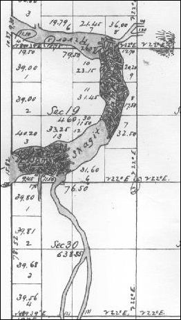
(Log Jams map)
This map, courtesy of Larry Kunzler, shows the location of the log jams in the Skagit River near future Mount Vernon, as drawn by surveyors sometime before 1877. Does anyone know the name of the creek entering the river from the northeast? The stream entering the river from the south on the map would later be named Britt's Slough.

      The Skagit flows into the Sound by two mouths, called the North and South forks, forming a delta, on which the new townsite of Skagit City has been laid out. It is located upon bottom land, above the reach of high water. The North Fork is about five miles long and enters the Sound about five miles [south] from LaConner, and the Swinomish flats are considered part of the river valley. The South Fork is the main channel, about eight miles long, and can be easily ascended by light-draught steamers at any season of the year.
      The peculiar nature of the river is the Jam, about two miles above Skagit City. The lower portion of this obstruction is about a quarter of a mile in length, and the river is clear for three-fourths of a mile to the upper jam, which is half a mile long. It is composed of driftwood, the accumulation of many years, which has become so firmly interwoven that its removal is an engineering problem of no small magnitude. The jam is the great bar to an extension of settlement and the progress of civilization to the head of the river. Only two families have settled above the jam. [Journal Ed. note: at this point, we know of only one such family that was "above" or north of the jam, that being Jasper Gates, who claimed the land that included most of downtown and northern Mount Vernon. His fellow settler, David E. Kimble was located near what is now called Britt's Slough — on the point beside the lower jam. The writer may have meant Joseph F. Dwelley, who pre-empted a claim beside Gates, but by the time this article was written, Dwelley had already removed his family to LaConner. We are still trying to determine where Dwelley's original claim was located and we hope that a reader can eventually help us.] . . .
      Washington Standard: Logging can be carried on only to a limited extent until after their removal, as the high land is too far back from the river to haul lumber from. Even the most favorable townsite, Skagit City, was located on the bottomland, near the forks, for the reason of there being no high land on the river below the jam.
      Perhaps no river in this Territory offers greater inducements than this for settlement, provided this jam was removed. The bottomland, timbered mainly with alder, vine maple, etc., is more easily cleared than the Stillaguamish, Snohomish, or most other river bottomlands in the Territory. The timber on the high land is of excellent quality, as well as easy to get out and float down, there being few obstacles in running logs, after the removal of the jams, to what are found on other rivers, the current of the Skagit being steadier and slower than the Snohomish [River to the south].


Removal of Skagit Jams
From Washington Standard, Dec. 1, 1877 transcription
      Capt. J. S. Hill, of the steamer Fanny Lake, informs the [Seattle] Intelligencer that the jam of logs in the Stillaguamish river was entirely swept out by the late freshet [flood] leaving that river navigable for steamers at eighteen miles above the present head of navigation. On Tuesday morning, Capt. hill was ascending the Skagit river and had nearly reached Gage's store [at Skagit City and the fork of the river] when he descried a vast raft of timber coming down the stream, and knowing there was but little chance to dodge it, he promptly stopped and backed around, after which he made the best of his way out of the river.
      He has no means of definite information, but believes that a large portion of the great jam has disappeared. Should this be the fact on the Skagit, as well as on the Stillaguamish, it opens up for settlement lands enough to support several thousand families, accessible by a few hours' steaming, to the second largest city on the northern coast. Even if the Stillaguamish alone is opened, five hundred families can find good homes and abundant employment there.


Description of Skagit City
From the 1906 Illustrated History of Skagit & Snohomish Counties
      It is in the very heart of the Skagit delta, surrounded on every side by one of the richest farming regions in the Northwest. Practically the whole region is in cultivation. The river here is broad and deep, furnishing facilities for extensive steamboat navigation and general boating, all of which is taken advantage of by numerous river boats. A ferry is maintained by the county at this point for the convenience of the public.
      Like a typical river town, Skagit City was built along the dike, the business houses being built in a row facing the water, beginning with Barker's single trading post in 1869. [Journal ed. note: Tom Robinson and I both suspect that this claim is inaccurate. Barker's store was very possibly located on what was once called Skagit Island, north across the North Fork of the river from the eventual Skagit City, and on the western shore of the main channel of the river. It was an island because a slough flowed along the northern and western sides.] Ten years later Skagit City was a thrifty village with hotels, stores, saloons, school, church and other public buildings. For a few years it continued to grow, but with the rise of Mount Vernon the older town gradually began to decline, losing its business houses to Mount Vernon one by one. At present only one remains, the general store of D.E. Gage, who succeeded more than a quarter of a century ago to the original establishment. Even the postoffice has been discontinued, the rural free delivery routes taking its place. The Skagit Queen, Captain H.H. MacDonald [actually McDonald], calls at the wharf when occasion requires.
      The town site was platted on the old homestead of W.H. McAlpine, one of the earliest of Skagit's pioneers. Originally the McAlpine dwelling and Barker's store stood further up the river, near the point a few hundred yards above the present buildings. Heavy floods have partly washed away the old site. Skagit City is associated with so much of importance and interest in connection with the early days of Skagit's settlement that it will always live in local history. Its mission as a town, however seems to have been fulfilled.


Endnote

1. Skagit City School
      Although the town of Skagit City faded in importance as the upriver towns of Mount Vernon and others grew, there was a large influx of settlers to the northern tip of Fir Island in the 1880s and a school in that area became necessary by 1888. We are studying the excellent research of the late Ronald Holttum and of Solveig Lee, who is very much alive and still researching the history of the Skagit County. Before the Skagit City school was erected, students had walked to the school in the Fir district to the south or to the Wilbur School on the farm of John Wilbur (and later owned by Joseph M. Gunderson), or they crossed the river to the Kelly School, named for the pioneer R.L. Kelly and located on the Peter Egtvet farm, upslope from the eastern shore of the river. That crossing was especially dangerous in the rainy, stormy months and the flood seasons.
      After the floodwaters of 1887 damaged the Kelly school, the new Skagit County created School District 3 on the east side of the river and a school was erected on the Ole N. Lee property near present Stackpole Road, a little north of the Kelly School, but on higher ground. We have not placed exactly where the new Skagit City District 57 School was erected in 1888, compared to the business buildings of the town as shown in the photo above, but we know that it was close enough to the water that it was undermined by floodwaters in 1901. That led the families to choose a 1/2-acre location on the Knute Lange farm (later known as the Vernal Lee farm) on higher ground west and away from the South Fork. That is where the old Skagit City School still stands today, at 1552 Moore Road; it served the area from 1902-1940 and Ronald Holttum bought the building and property in 1943. You can read more about that school and the current attempt to restore it in our companion article, "The Bell Tolls for Skagit School."    [Return]


2. Daniel E. and William Gage
      Starting in 1874 (and maybe even before), when the Fanny Lake sternwheeler brought U.S. mail to the Skagit River region, brothers William and Daniel Gage collected and transported mail for everyone living upriver. The mail was delivered to Daniel's Skagit City store and William or someone he hired would paddle a canoe down from the log jams to pick it up. By 1876, Daniel Gage erected the most substantial new building in Skagit City, a two-story structure, with the lower one for a store, warehouse and dwelling. The upper story was a public hall, where the first Skagit Ball was celebrated on Dec. 1, 1876, and lodge quarters for the Masons. When William C. Ewing promoted a public subscription campaign in 1884 to fund the removal of a log jam at the mouth of the Skagit and removal of drifts and snags all the way up to Sterling, Daniel Gage was treasurer of the group. By 1906, Skagit City was a mere shadow of its former self, having given over almost all commerce to Mount Vernon. Gage's store was the last business there, staying open until the Teen years of the early 20th Century.
      As we read more of Solveig Lee's extensive transcriptions of early Skagit County newspapers, we find that Daniel and William were preceded in the South Fork area by George Gage, who could have been a brother or a cousin. When we checked county burial records, Daniel is recorded as dying in 1931, age 82, born in Canada. There is no record for William. We also could not find a record for George, but there is a record for a George M. Gagen, who died in 1915 at age 55. Could that be a tyop? We hope a Gage descendant will read the story and share more genealogy with us. [Return]


3. William H. Sartwell
      We plan to profile Sartwell later this year but here is a brief capsule of his life and the reason for his importance to early Skagit River settlement. From the 1906 Illustrated History we know that "The first house to be built in the Skagit valley was erected in 1863 on the claim of W.H. Sartwell, now owned by Magnus Anderson, about five miles below Mount Vernon." That was on the North Fork of the Skagit River. When Northern Pacific Railroad surveyor D.C. Linsley ascended the river by canoe in May 1870, he noted in his diary that "The second night of the journey was spent at W. H. Sartwell's, a short distance up the Skagit [South Fork]." The 1906 Illustrated History also notes that Sartwell's original log cabin on the south fork was used for the first subscription school, along the Skagit River, in 1872. Sartwell's cabin was about two miles south of Skagit City near Mann's Landing, which later became the village of Fir. Skagit City was located on the claim of Sartwell's neighbor to the north, Edward McAlpine. In 1877, Snohomish editor Eldridge Morse found him in the same South Fork location and married, and noted sadness in the family: "Sartwell was set back when his infant child died that month [April]." [Return]

4. Edward McAlpine
      Edward McAlpine was born in Ontario, Canada, in 1836 and emigrated to California in the 1860s, working there and in Utah mainly in mining. According to Lottie Roeder Roth (History of Whatcom County, 1926), he came to Washington Territory in 1875 and preempted the claim on the South Fork of the Skagit where Skagit City was established. [We are still researching to determine if McAlpine could have arrived before that date.] His wife, Jane (Ewing) was a native of Glasgow, Scotland, born there in 1843. They had three children together, Belle, Edward and Jean. Edward moved his family to Whatcom County in 1883, where he again farmed; he died there in 1891. Jane survived him as a widow for 34 years, dying on Jan. 3, 1925 at age 82. When Jane sold the family farm in 1922, son Edward bought 125 acres on the Nooksack near the town of Ferndale and became a progressive farmer. In 1905, he married Alice Welch, the daughter of Dr. J.J. and Eva (Sloan) Welch. Dr. Welch came to the area 1882 and was the first licensed doctor in Ferndale.[Return]

5. Michael Horan's Hotel
      Brothers Michael and David Horan built the grand hotel at Skagit City. Robert Thompson is listed as another hotel owner there in various stories. The Horans may have erected the hotel for Mr. Thompson or may have sold it to him. We are unsure of the connection between this Thompson and the later Dr. Thompson. Solveig Lee's transcriptions of early county newspapers show that David Horan still lived in the Skagit City/Fir Island area through the 1890s. The National Register of Historic Places shows a hotel at 2 Horan Road, Wenatchee, that is still standing, and which was built by and for a Michael Horan. [Return]

Links, background reading and sources

Story posted on May 1, 2007, last updated May 7, 2016
Please report any broken links so we can update them


Getting lost trying to navigate or find stories on our site?
Read how to sort through our 700-plus stories.
Return to the new-domain home page
Links for portals to subjects and towns
Newest photo features
Search entire site
(bullet) See this Journal Timeline website of local, state, national, international events for years of the pioneer period.
(bullet) Did you enjoy this story? Remember, as with all our features, this story is a draft and will evolve as we discover more information and photos. This process continues until we eventually compile a book about Northwest history. Can you help?
(bullet) Remember; we welcome correction & criticism.

You can click the donation button to contribute to the works of this website and of Skagit County Historical Society & Museum.

You can read the history websites about our prime sponsors
Would you like information about how to join them in advertising?

(bullet) Our newest sponsor: Cygnus Gallery, 109 Commercial St., half-block uphill from Main Street, LaConner. Open Fridays, Saturdays and Sundays from 11 am to 5 p.m., featuring new monthly shows with many artists, many local. Across the street from Maple Hall, 1886 Bank Building and Marcus Anderson's 1969 historic cabin. Their website will be up in early 2010.
(bullet) Oliver-Hammer Clothes Shop at 817 Metcalf Street in downtown Sedro-Woolley, 89 years.
(bullet) Peace and quiet at the Alpine RV Park, just north of Marblemount on Hwy 20, day, week or month, perfect for hunting or fishing
Park your RV or pitch a tent by the Skagit River, just a short drive from Winthrop or Sedro-Woolley
(bullet) Joy's Sedro-Woolley Bakery-Cafe at 823 Metcalf Street in downtown Sedro-Woolley.
(bullet) Check out Sedro-Woolley First section for links to all stories and reasons to shop here first
or make this your destination on your visit or vacation.
(bullet) Are you looking to buy or sell a historic property, business or residence?
We may be able to assist. Email us for details.

Looking for something special on our site? Enter name, town or subject, then press "Find" Search this site powered by FreeFind
    Did you find what you were seeking? We have helped many people find individual names or places, so o email if you have any difficulty.
    Tip: Put quotation marks around a specific name or item of two words or more, and then experiment with different combinations of the words without quote marks. We are currently researching some of the names most recently searched for — check the list here. Maybe you have searched for one of them?
Please sign our guestbook so our readers will know where you found out about us, or share something you know about the Skagit River or your memories or those of your family. Share your reactions or suggestions or comment on our Journal. Thank you for taking time out of your busy day to visit our site.

View My Guestbook
Sign My Guestbook
Email us at: skagitriverjournal@gmail.com
(Click to send email)
Mail copies/documents to Street address: Skagit River Journal c/o Skagit County Historical Society & Museum PO Box 818, 501 S. 4th St., La Conner, WA 98257